So what exactly do we mean when we say offshore winds? Let’s break it down: https://abs.twimg.com/emoji/v2/... draggable="false" alt="🧵" title="Thread" aria-label="Emoji: Thread"> #CaFire
Air moves from areas of higher pressure to lower pressure as the atmosphere continually tries to restore balance to the environment. We call this the Pressure Gradient Force, or PGF for short.
Air moves from areas of higher pressure to lower pressure as the atmosphere continually tries to restore balance to the environment. We call this the Pressure Gradient Force, or PGF for short.
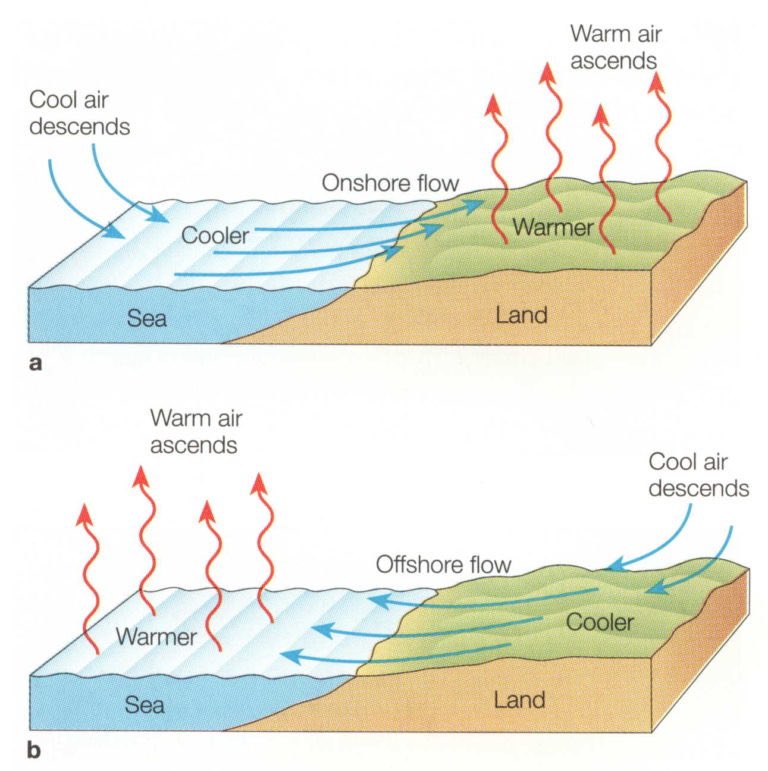
In California we tend to focus on the pressure gradient that develops between highs just off the coast and inland lows. Oftentimes we’ll observe cold  https://abs.twimg.com/emoji/v2/... draggable="false" alt="🥶" title="Cold face" aria-label="Emoji: Cold face"> pacific air pool in to the warmer, lower pressure environment inland. This transfer is commonly referred to as our sea breeze.
Sea breezes and the term “onshore winds” tend to be used interchangeably in this case and so a good way to remember what onshore refers to is to think of it in the sense that these winds travel from the sea and ON to the shoreline.
As the previous pic implies, offshore winds develop as air from higher pressure inland moves towards lower coastal pressure (e.g land breeze). This reverse flow commonly occurs overnight which tends to coincide w/the timing of some of our historic offshore wind events.

 Read on Twitter
 #CaFire Air moves from areas of higher pressure to lower pressure as the atmosphere continually tries to restore balance to the environment. We call this the Pressure Gradient Force, or PGF for short." title="So what exactly do we mean when we say offshore winds? Let’s break it down:https://abs.twimg.com/emoji/v2/... draggable="false" alt="🧵" title="Thread" aria-label="Emoji: Thread"> #CaFire Air moves from areas of higher pressure to lower pressure as the atmosphere continually tries to restore balance to the environment. We call this the Pressure Gradient Force, or PGF for short." class="img-responsive" style="max-width:100%;"/>
 pacific air pool in to the warmer, lower pressure environment inland. This transfer is commonly referred to as our sea breeze." title="In California we tend to focus on the pressure gradient that develops between highs just off the coast and inland lows. Oftentimes we’ll observe cold https://abs.twimg.com/emoji/v2/... draggable="false" alt="🥶" title="Cold face" aria-label="Emoji: Cold face"> pacific air pool in to the warmer, lower pressure environment inland. This transfer is commonly referred to as our sea breeze." class="img-responsive" style="max-width:100%;"/>


