Whether you received a ShakeAlert-powered alert or not, a M4.7 earthquake occurred in northeast California last night near Lake Tahoe. Let’s fly to the eastern Sierra Nevada for this special edition of #FaultFriday.
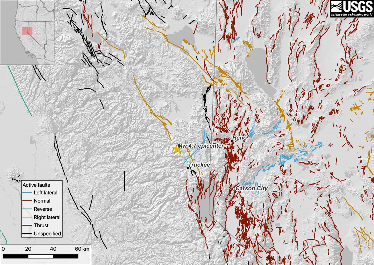
The earthquake occurred here, about 20 km or 13 miles northwest of Truckee, California. The epicenter of the earthquake is shown with a yellow star, with active faults shown colored by their style of faulting.
Your eyes aren’t fooling you- there are…a lot…of faults in this neck of the woods  https://abs.twimg.com/emoji/v2/... draggable="false" alt="👀" title="Augen" aria-label="Emoji: Augen"> And no, your eyes aren’t fooling you again, the epicenter appears to plot *between* two faults and not actually on a fault, dipping or not
  https://abs.twimg.com/emoji/v2/... draggable="false" alt="👀" title="Augen" aria-label="Emoji: Augen">
  https://abs.twimg.com/emoji/v2/... draggable="false" alt="👀" title="Augen" aria-label="Emoji: Augen"> Is this a big deal?
NE CA is the part of the Walker Lane tectonic province, full of distributed lateral (right- and left-lateral) & normal faulting. In general, right-lateral faults trend NW, and left-lateral faults trend NE. If you have a headache looking at this map, imagine studying this area!
The Walker Lane is enigmatic. It can be hard to pin down discrete evidence of deformation, given the complex tectonic environment, thick vegetation in places, and overlapping types of faulting.
This puts the Walker Lane in stark contrast to, let’s say, the central San Andreas fault, along which deformation is generally localized to narrow fault zone, EQs can be larger and happen more frequently, & the vegetation is more sparse, all making the fault highly recognizable.
So, is it a big deal that the epicenter of this event doesn’t appear on an active fault? Well, just because the fault isn’t on the map doesn’t mean there’s not a fault there.
The focal mechanism tells us two orientations of the potential fault that ruptured, made with data from seismic waves in the region. Here, the two fault choices are a steeply dipping, NW-striking right-lateral fault or a steeply dipping, NE-striking left-lateral fault.
Based on the existing knowledge of faults in this area, the NW-striking right-lateral fault would appear to connect a step between two mapped right-lateral faults to the north and south of the epicenter, the Mohawk Valley fault to the north and the Polaris fault the south.
We can’t exactly discount the NE-striking left-lateral fault yet, though, given that there are plenty of similar faults in this area, like the Dog Valley fault <10 km to the south.
The USGS is actively funding academic research on these fault systems through the National Earthquake Hazard Reduction Program grants scheme. This is truly an area of cutting edge (no pun intended  https://abs.twimg.com/emoji/v2/... draggable="false" alt="😉" title="Zwinkerndes Gesicht" aria-label="Emoji: Zwinkerndes Gesicht">) fault science!
That’s all from us for now, but stay tuned for more information as it becomes available. Be sure to check @USGS and @USGS_ShakeAlert for more info, too!

 Read on Twitter


