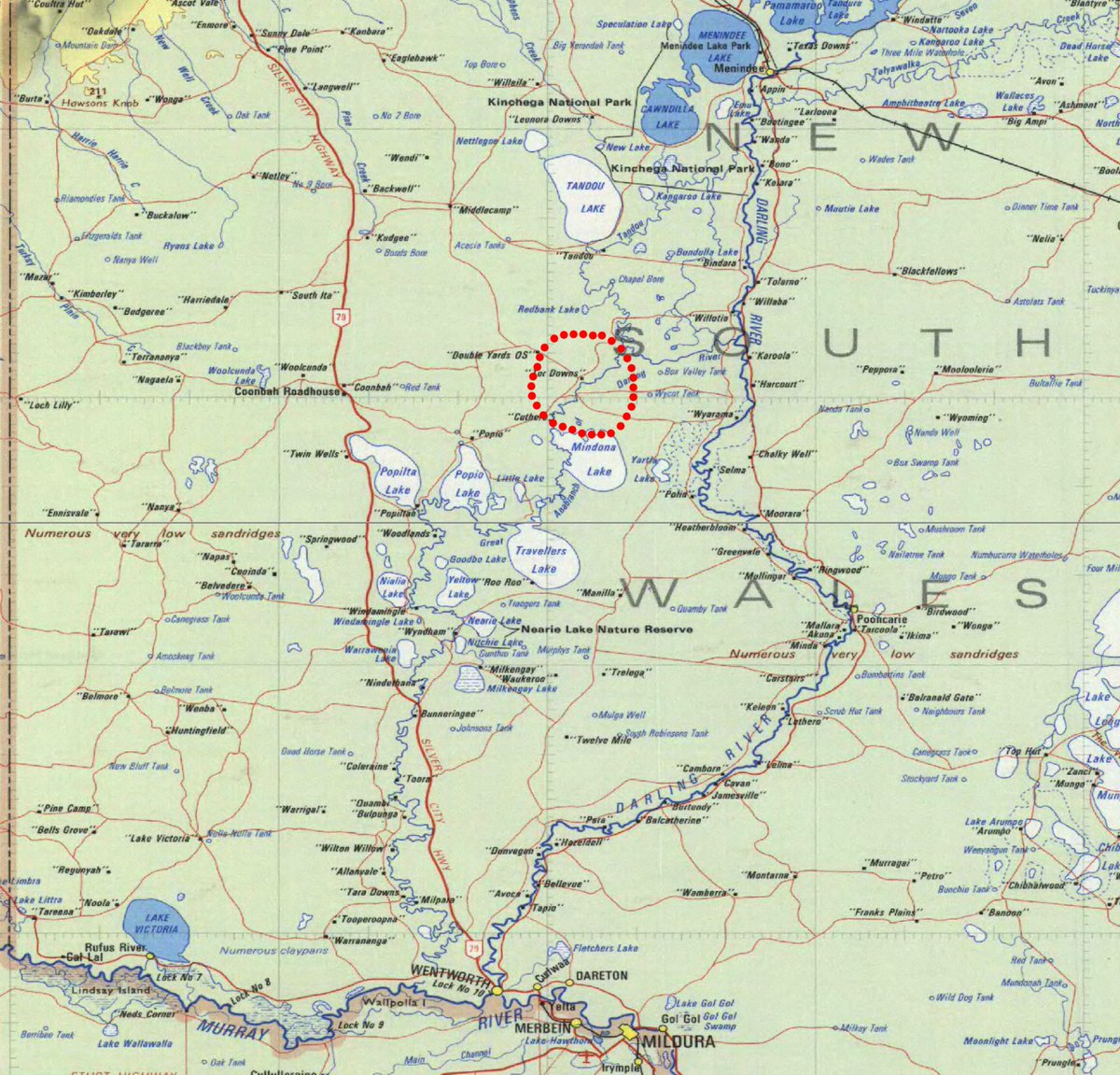
This Baaka-Darling, at Wilcannia. https://twitter.com/Gergyl/status/1360765434174185473?s=19">https://twitter.com/Gergyl/st...
The big public cotton-water dams around the catchment rim are all still near-empty, so there won& #39;t be any flow in the rivers below those. But there are other rivers ... and there are also massive & #39;floodplain harvesting& #39; suckers, being readied right now, to suck, and suck.
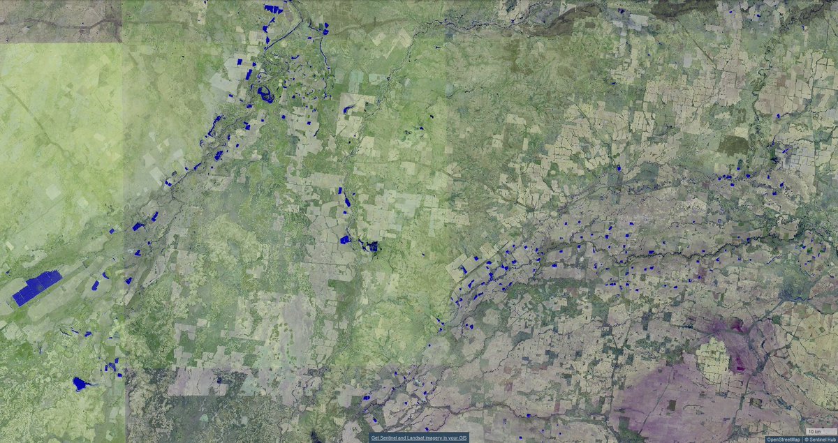
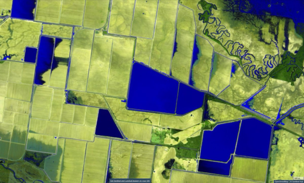
...To fill private off-stream water storages like these (dark blue, cotton-central of the & #39;Northern Basin& #39;, March last year). But many of those are already part-full; how much more water can they take? We simply do not know.
...Because the NSW regulator (DPIE) is so utterly useless that it recently had to try to estimate the number and size of such storages from satellite imagery.
Now thinking this is all moving too fast for much of an outcome in the lower Baaka. Fingers crossed. https://twitter.com/althecat/status/1373223741380046851?s=20">https://twitter.com/althecat/...
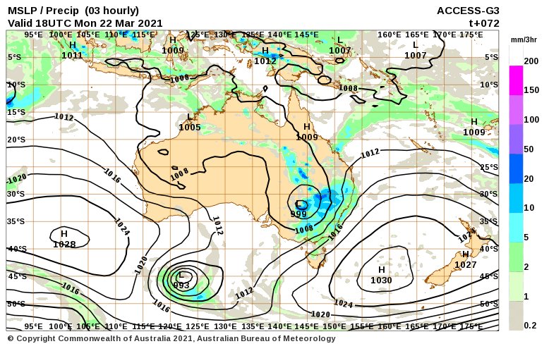
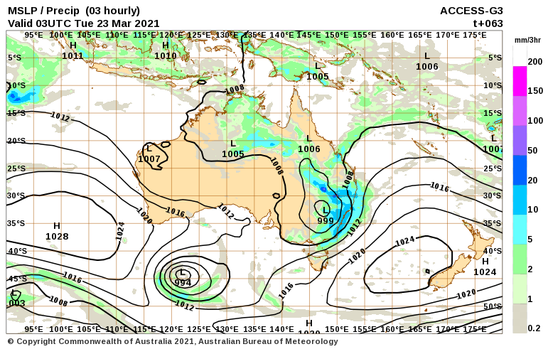
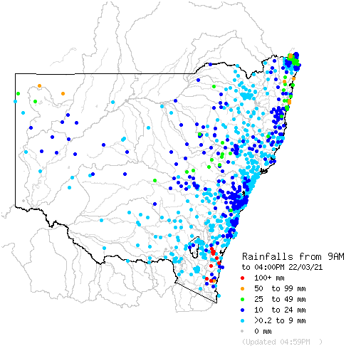
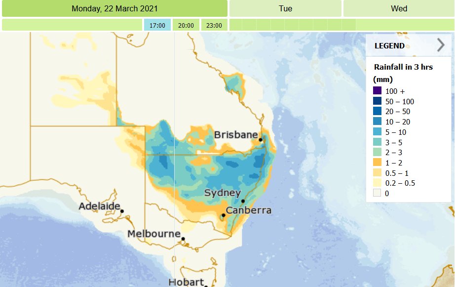
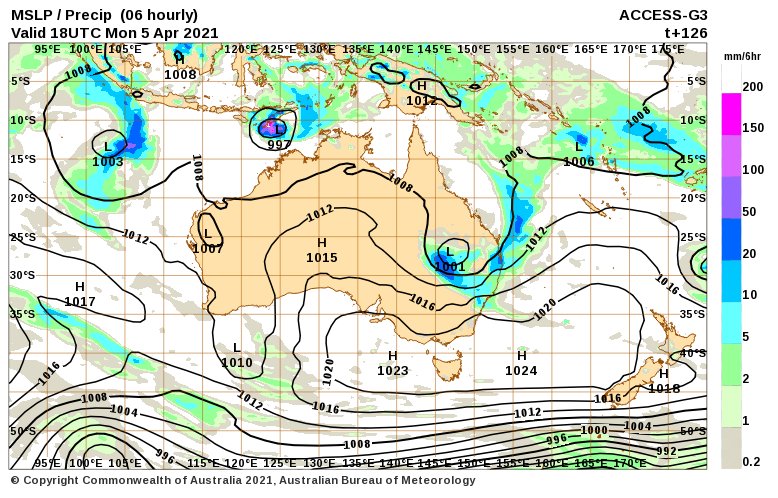
Needs the low to happen further inland than ECMWF has it. BOM ACCESS is still showing that for Tuesday, but it moves off too quickly:
http://www.bom.gov.au/australia/charts/viewer/index.shtml">https://www.bom.gov.au/australia...
http://www.bom.gov.au/australia/charts/viewer/index.shtml">https://www.bom.gov.au/australia...
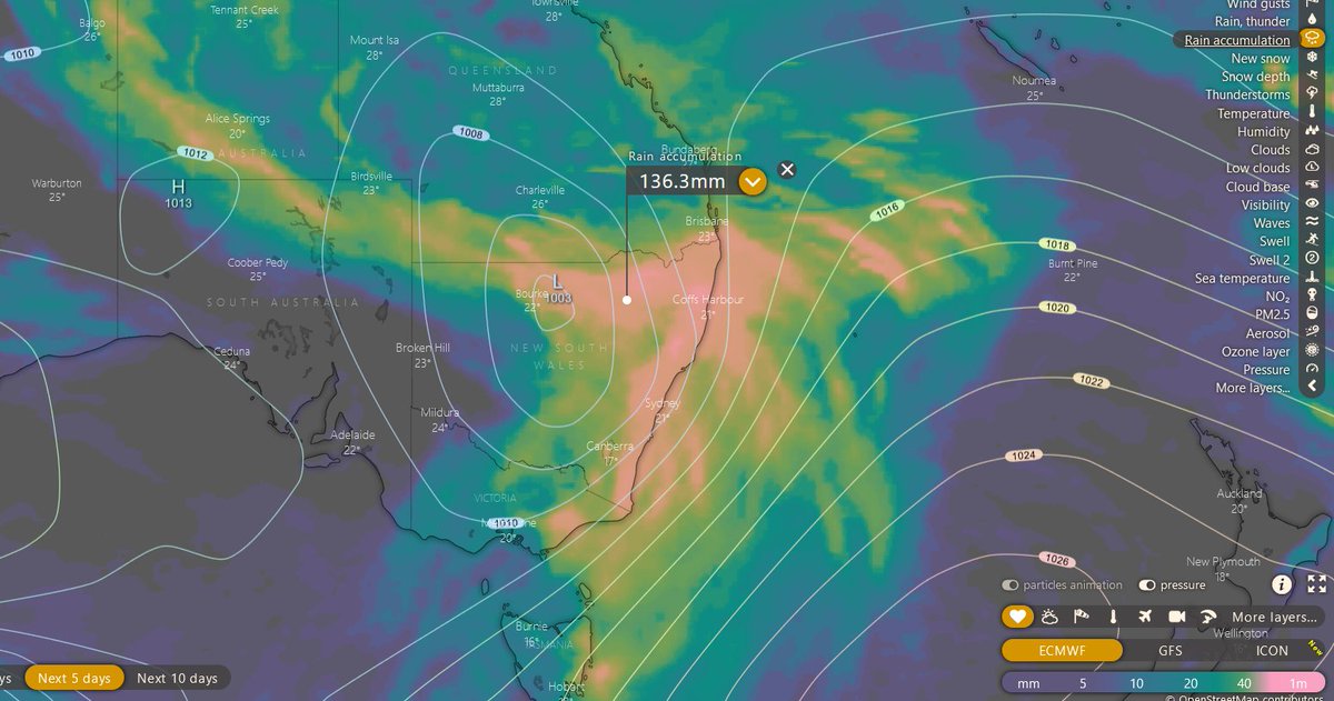
Dunno; this isn& #39;t too bad -- EC at Windy. Catchment is wet; will run off some.
https://www.windy.com/-Rain-accumulation-rainAccu?rainAccu,2021-03-23-00,-29.651,144.844,5,i:pressure,m:cOAakkH">https://www.windy.com/-Rain-acc...
https://www.windy.com/-Rain-accumulation-rainAccu?rainAccu,2021-03-23-00,-29.651,144.844,5,i:pressure,m:cOAakkH">https://www.windy.com/-Rain-acc...
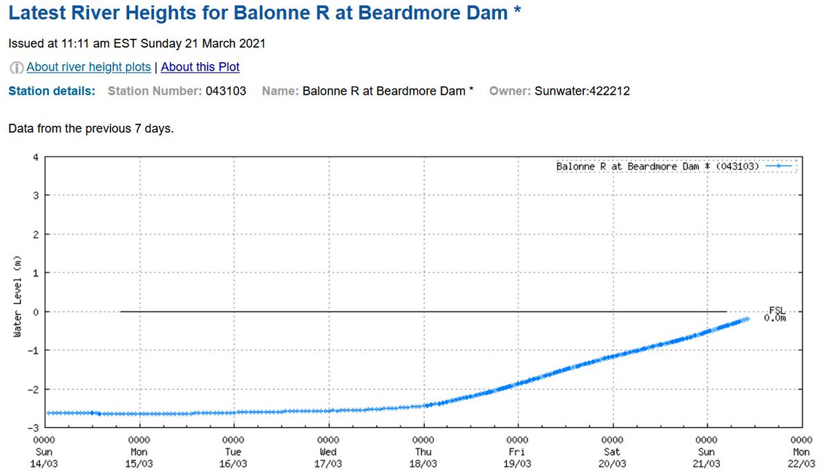
Beardmore Dam is about to spill, the first of the big cotton-water dams in the Baaka-Darling catchment to fill.
http://www.bom.gov.au/fwo/IDQ65396/IDQ65396.043103.plt.shtml">https://www.bom.gov.au/fwo/IDQ65...
http://www.bom.gov.au/fwo/IDQ65396/IDQ65396.043103.plt.shtml">https://www.bom.gov.au/fwo/IDQ65...
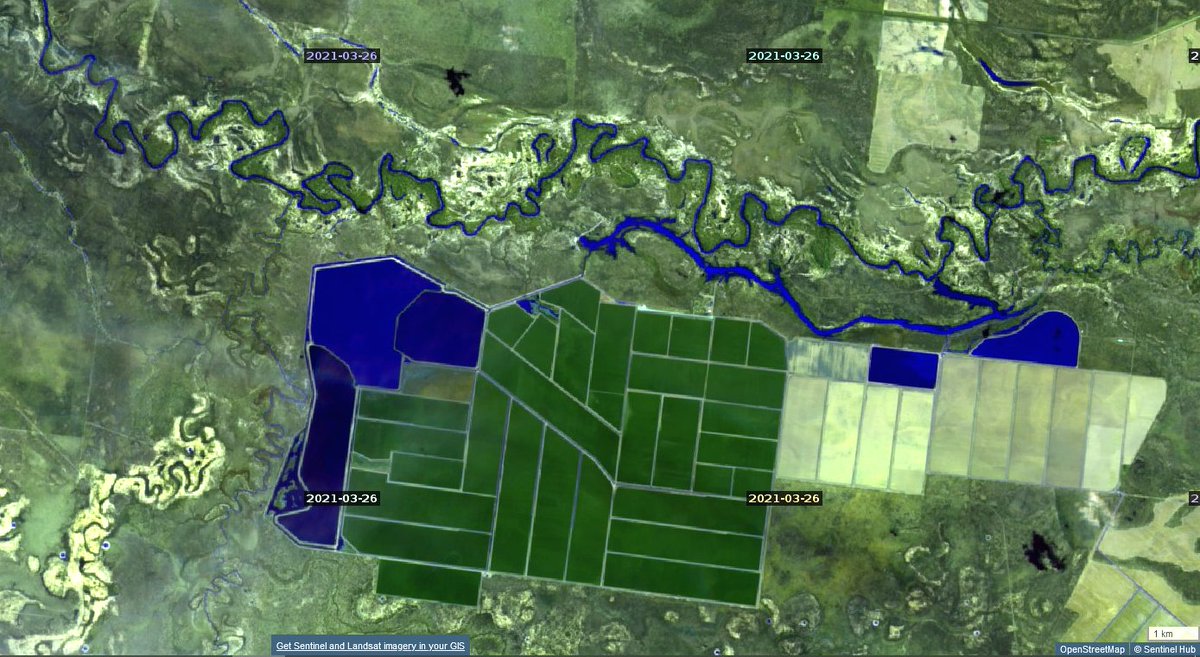
...But that& #39;s only 82 GL. Next, the little flood coming down the Balonne will have to run the gauntlet of Cubbie Station. Most of its water storages are currently empty (dark blue is water in this false-colour infrared image):
https://apps.sentinel-hub.com/sentinel-playground/?source=S2&lat=-28.646908708472537&lng=147.7819061279297&zoom=11&preset=3_FALSE_COLOR__URBAN_&layers=B01,B02,B03&maxcc=20&gain=0.9&gamma=0.9&time=2020-09-01%7C2021-03-13&atmFilter=ATMCOR&showDates=true">https://apps.sentinel-hub.com/sentinel-...
https://apps.sentinel-hub.com/sentinel-playground/?source=S2&lat=-28.646908708472537&lng=147.7819061279297&zoom=11&preset=3_FALSE_COLOR__URBAN_&layers=B01,B02,B03&maxcc=20&gain=0.9&gamma=0.9&time=2020-09-01%7C2021-03-13&atmFilter=ATMCOR&showDates=true">https://apps.sentinel-hub.com/sentinel-...
Cubbie reportedly can store up to 469 GL, nearly six Beardmore Dams. It appears still to be licenced to take nearly all of that, in a single season (though with river flow level restrictions).
That& #39;s on top of all the & #39;overland flow& #39; harvesting storages along the river between Beardmore Dam and Cubbie Station. Recall that this is where you paid Minister Taylor& #39;s one-time company 80 million dollars for its floodwater take & #39;rights& #39; (area marked, plus another downstream).
Am still concerned that it& #39;s all moving too fast. Is nearly all gone by tomorrow afternoon -- a bit hangs around over the border rivers, that is all:
http://www.bom.gov.au/australia/meteye/">https://www.bom.gov.au/australia...
http://www.bom.gov.au/australia/meteye/">https://www.bom.gov.au/australia...
There& #39;s small rises in most gauges now, so some runoff is happening.
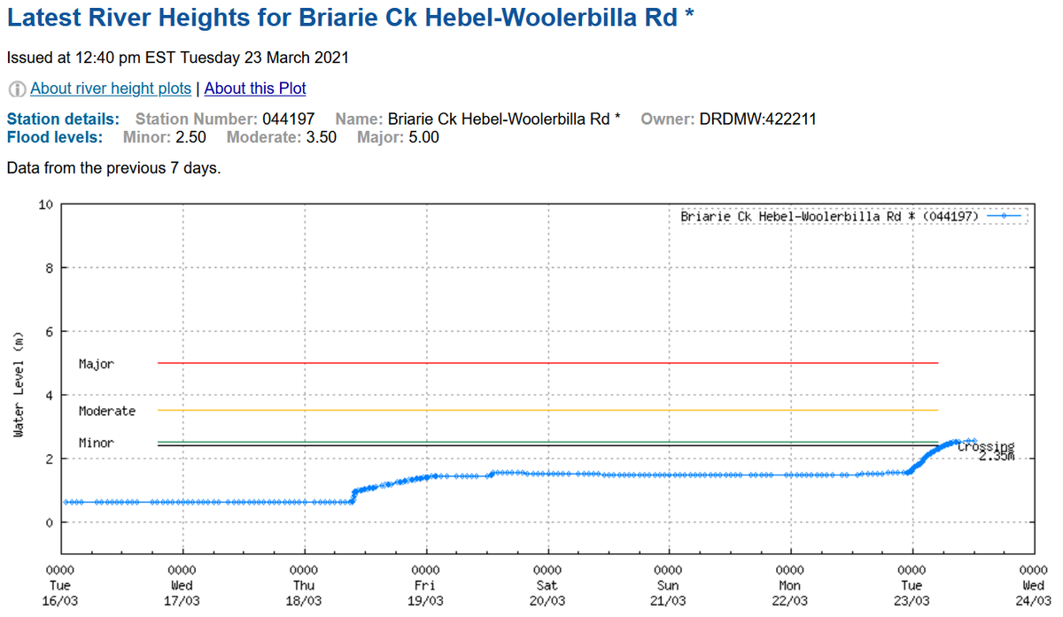
This is a little bit of the Balonne flow that has run the gauntlet of all the Queensland cotton suckers (including Cubbie) and made it to the NSW border.
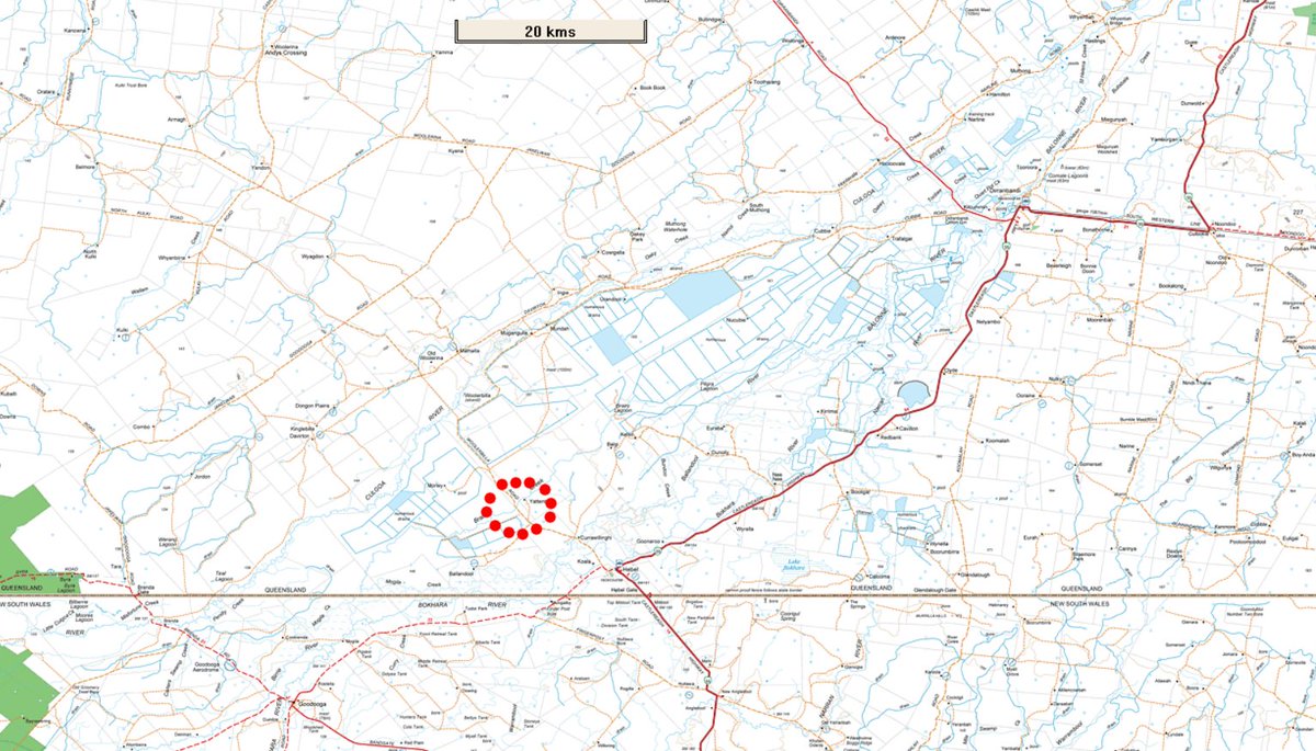
...Almost. Here, I think:
(& #39;Briarie Ck& #39; seems to be an error. Natmap has & #39;Braire Ck& #39;. It& #39;s gauge 422211: https://water-monitoring.information.qld.gov.au...?ppbm=422211A&rs&1&rslf_org">… https://water-monitoring.information.qld.gov.au...?ppbm=422211A&rs&1&rslf_orgter-monitoring.information.qld.gov.au/?ppbm=422211A&)
(& #39;Briarie Ck& #39; seems to be an error. Natmap has & #39;Braire Ck& #39;. It& #39;s gauge 422211: https://water-monitoring.information.qld.gov.au...?ppbm=422211A&rs&1&rslf_org">… https://water-monitoring.information.qld.gov.au...?ppbm=422211A&rs&1&rslf_orgter-monitoring.information.qld.gov.au/?ppbm=422211A&)
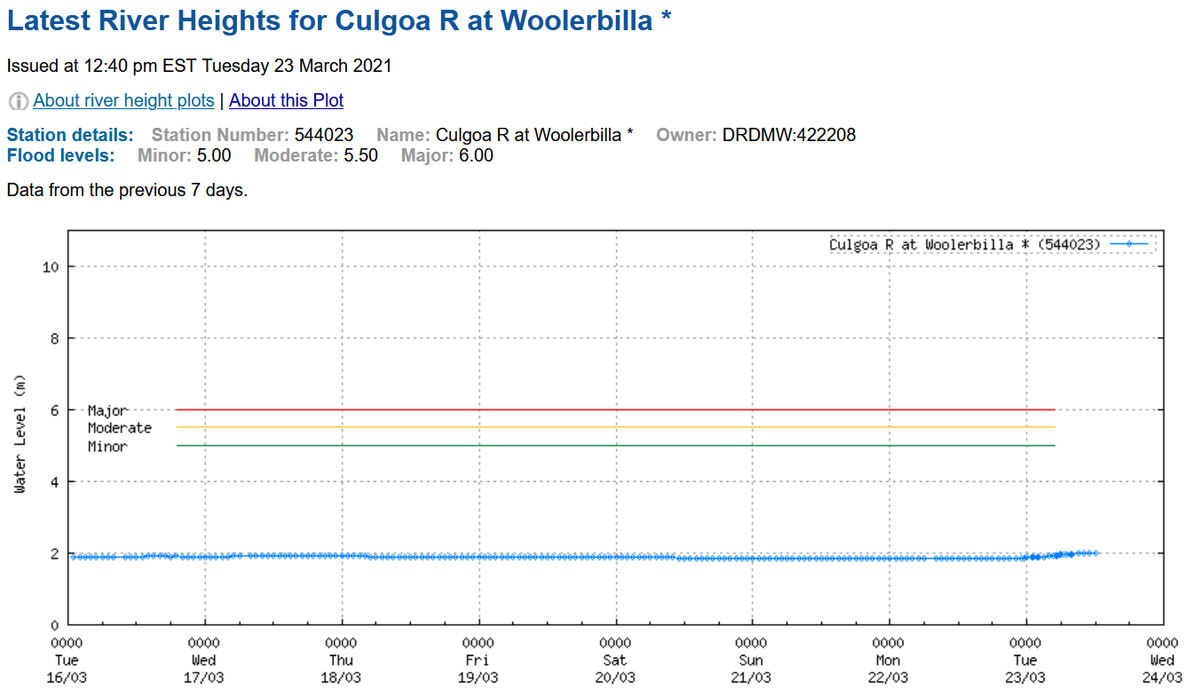
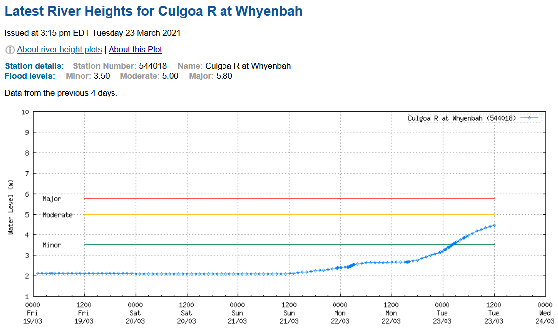
The Culgoa, which is the braided channel that Cubbie Station has dammed up and actually sucks from, is yet to see more than a trickle (Qld WMIP has 2 cumecs):
Is anyone watching? Who? Why not?
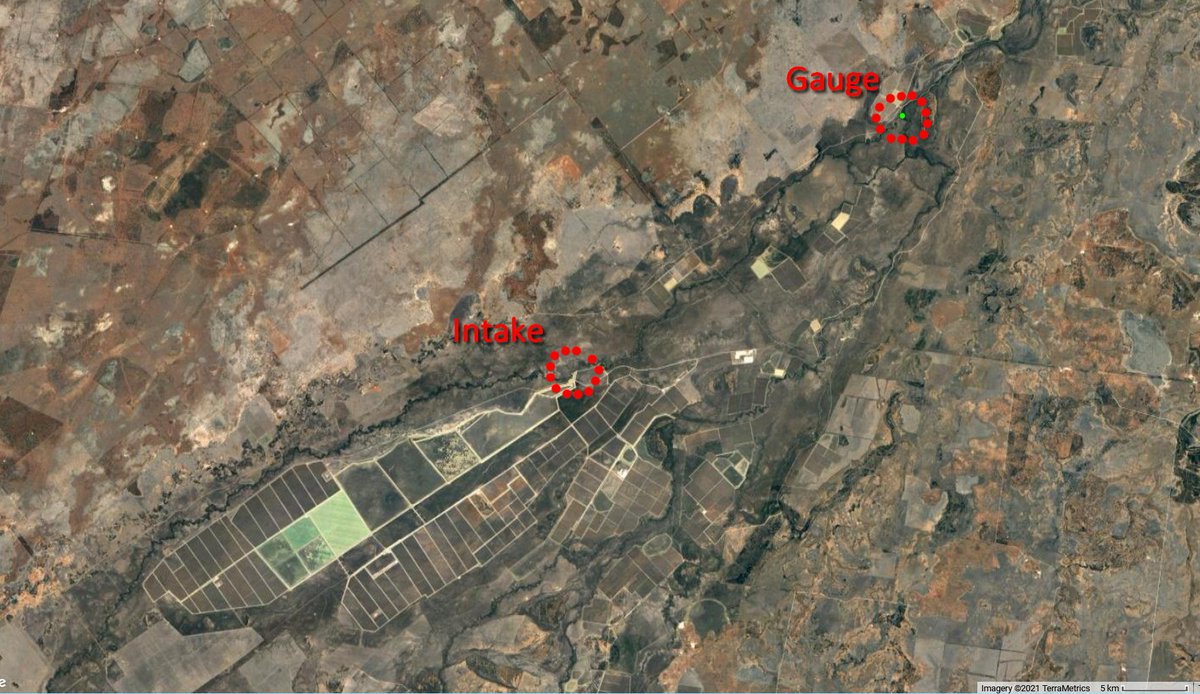
This gauge is about 25 km upstream of the Cubbie Station weir and intake (DNRME 422204A / BOM 544018).
http://www.bom.gov.au/fwo/IDN60238/IDN60238.544018.plt.shtml">https://www.bom.gov.au/fwo/IDN60...
http://www.bom.gov.au/fwo/IDN60238/IDN60238.544018.plt.shtml">https://www.bom.gov.au/fwo/IDN60...
Here: https://water-monitoring.information.qld.gov.au...?ppbm=422204A&rs&1&rslf_org">… https://water-monitoring.information.qld.gov.au...?ppbm=422204A&rs&1&rslf_orgter-monitoring.information.qld.gov.au/?ppbm=422204A&
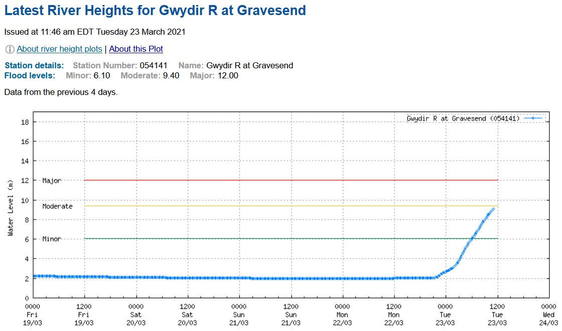
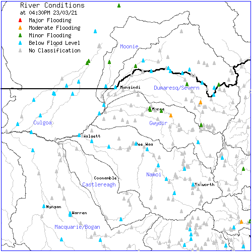
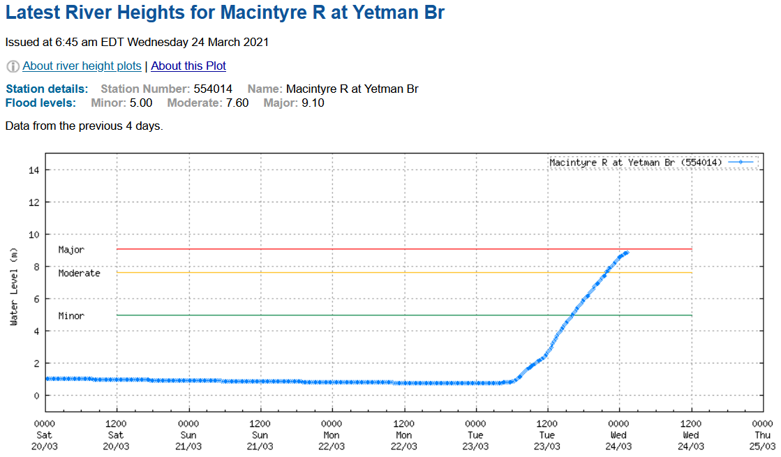
Rain is finished. Best flow is going to be in the Gwydir and Dumaresq, both system with many huge cotton-suckers. Not seeing much in the Condamine–Balonne (will be a small second peak from the Condamine), nor in the other Qld rivers. So will not be nothing, but not much.
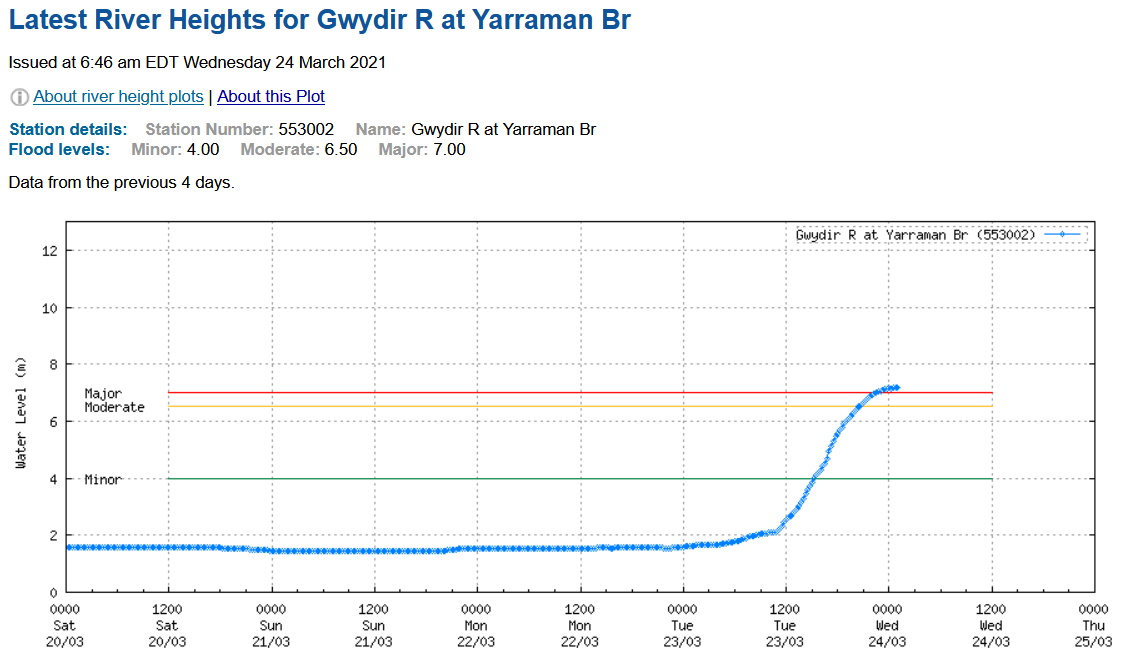
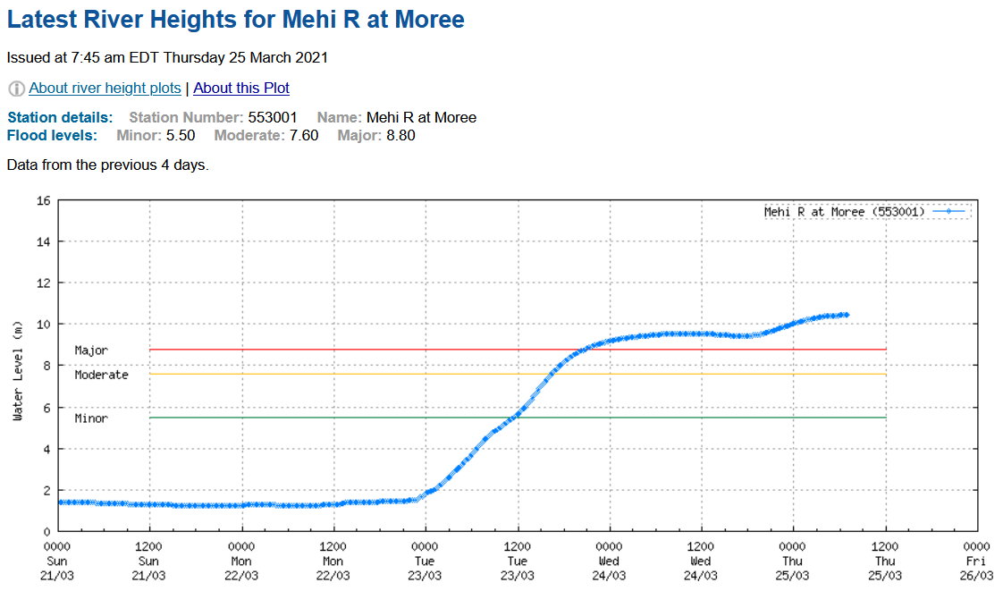
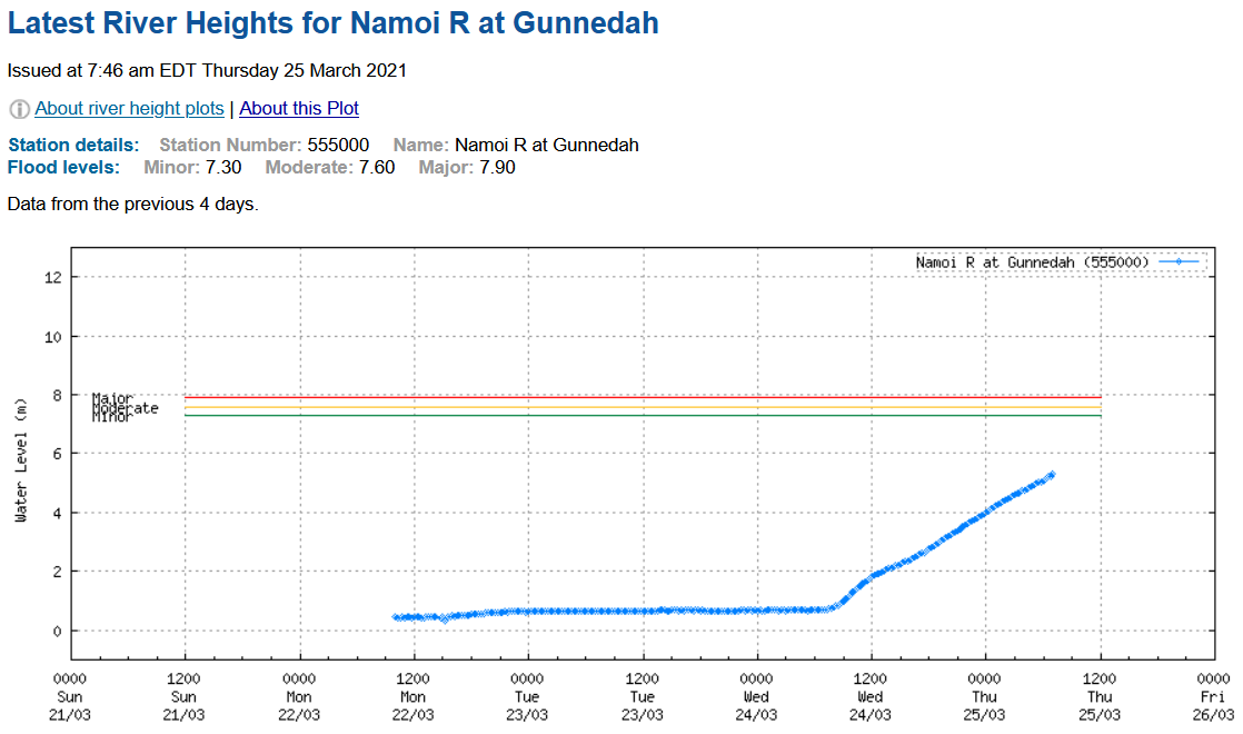
Gywdir near Moree (left); that& #39;s pretty good. And the Macintyre above the confluence (right), ok too. It& #39;s enough for a Baaka flow I think, even after the all the cotton-suckers.
These cotton-suckers, literally a thousand of them* -- your Barnaby-Barilaro-Berejiklian & #39;floodplain harvesting& #39; (that& #39;s pollie-lie for sucking-out-the-rivers).
(*There& #39;s 1395 large private water storages across the NSW Northern Basin, according to S&J.) https://twitter.com/SlatteryJohnso/status/1366260280519319553?s=20">https://twitter.com/SlatteryJ...
(*There& #39;s 1395 large private water storages across the NSW Northern Basin, according to S&J.) https://twitter.com/SlatteryJohnso/status/1366260280519319553?s=20">https://twitter.com/SlatteryJ...
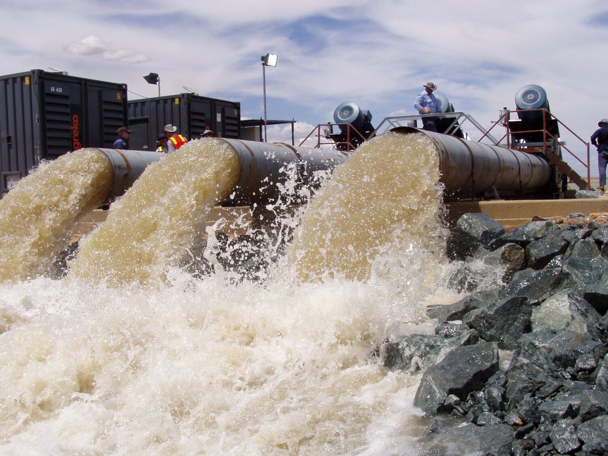
What& #39;s a cotton-sucker? Banks of high-flow, low-head axial flow pumps, intended to suck a lot of water from a river as quickly as possible, because rules limit the river level above which extraction is permitted (haha).
(For illustration only -- pump supplier& #39;s images.)
(For illustration only -- pump supplier& #39;s images.)
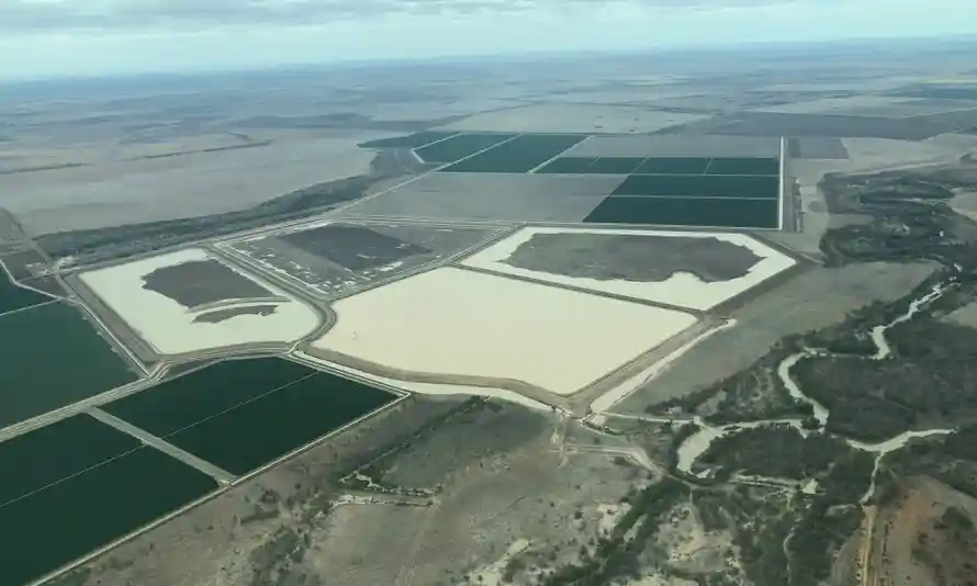
...Into huge private off-stream storages, an & #39;ordinary& #39; one maybe a kilometre square by five metres deep (that& #39;s 5 gigalitres of storage).
This one& #39;s in southern Queensland:
This one& #39;s in southern Queensland:
That& #39;s a big flood now, more than I expected -- still rising, as are gauges upstream. More to come yet.
And Moree is having another little rise too. Gauges upstream there are falling; that& #39;s probably it.
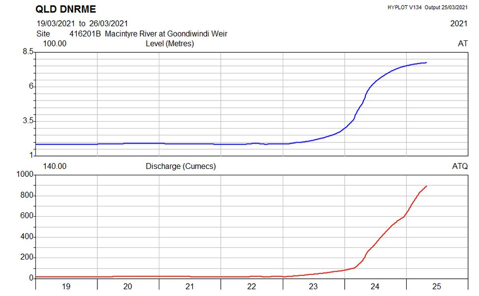
The flow at Gundi is approaching 1000 cumecs -- currently 898 m³/s == 78 GL/day. That& #39;s a serious number.
https://water-monitoring.information.qld.gov.au...?ppbm=416201B&rs&1&rscf_org">… https://water-monitoring.information.qld.gov.au...?ppbm=416201B&rs&1&rscf_orgter-monitoring.information.qld.gov.au/?ppbm=416201B&
https://water-monitoring.information.qld.gov.au...?ppbm=416201B&rs&1&rscf_org">… https://water-monitoring.information.qld.gov.au...?ppbm=416201B&rs&1&rscf_orgter-monitoring.information.qld.gov.au/?ppbm=416201B&
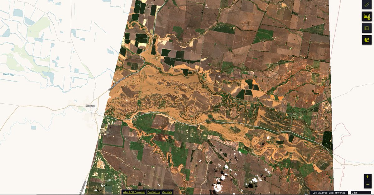
Floodwater upstream of Moree, this morning.
https://apps.sentinel-hub.com/eo-browser/?zoom=12&lat=-29.42689&lng=149.92424&themeId=DEFAULT-THEME&datasetId=S2L2A&fromTime=2021-03-25T00%3A00%3A00.000Z&toTime=2021-03-25T23%3A59%3A59.999Z&layerId=1_TRUE_COLOR&visualizationUrl=https%3A%2F%2Fservices.sentinel-hub.com%2Fogc%2Fwms%2Fbd86bcc0-f318-402b-a145-015f85b9427e&gain=2">https://apps.sentinel-hub.com/eo-browse...
https://apps.sentinel-hub.com/eo-browser/?zoom=12&lat=-29.42689&lng=149.92424&themeId=DEFAULT-THEME&datasetId=S2L2A&fromTime=2021-03-25T00%3A00%3A00.000Z&toTime=2021-03-25T23%3A59%3A59.999Z&layerId=1_TRUE_COLOR&visualizationUrl=https%3A%2F%2Fservices.sentinel-hub.com%2Fogc%2Fwms%2Fbd86bcc0-f318-402b-a145-015f85b9427e&gain=2">https://apps.sentinel-hub.com/eo-browse...
...And at Gundi, in infrared false-colour to highlight the floodwater and the private stored water.
https://apps.sentinel-hub.com/eo-browser/?zoom=12&lat=-28.63862&lng=150.33485&themeId=DEFAULT-THEME&datasetId=S2L1C&fromTime=2021-03-25T00%3A00%3A00.000Z&toTime=2021-03-25T23%3A59%3A59.999Z&layerId=4-FALSE-COLOR-URBAN&visualizationUrl=https%3A%2F%2Fservices.sentinel-hub.com%2Fogc%2Fwms%2F42924c6c-257a-4d04-9b8e-36387513a99c&gain=2.7&gamma=0.8">https://apps.sentinel-hub.com/eo-browse...
https://apps.sentinel-hub.com/eo-browser/?zoom=12&lat=-28.63862&lng=150.33485&themeId=DEFAULT-THEME&datasetId=S2L1C&fromTime=2021-03-25T00%3A00%3A00.000Z&toTime=2021-03-25T23%3A59%3A59.999Z&layerId=4-FALSE-COLOR-URBAN&visualizationUrl=https%3A%2F%2Fservices.sentinel-hub.com%2Fogc%2Fwms%2F42924c6c-257a-4d04-9b8e-36387513a99c&gain=2.7&gamma=0.8">https://apps.sentinel-hub.com/eo-browse...
The flood in the Mehi (Gwydir) has reached the Baaka (Barwon-Darling) at Collarenebri (gauge is below the Moomin Creek re-confluence). At ~10 GL/day it isn& #39;t a huge flow, but is not nothing:
Next it has to run the gauntlet of the cotton-suckers around Walgett, then Bourke. Likes of these at Miralwyn Cotton below Walgett, but the storages there all already have water (seems to be carry-over from the 2020/21 season). Note the scale bar, bottom right:
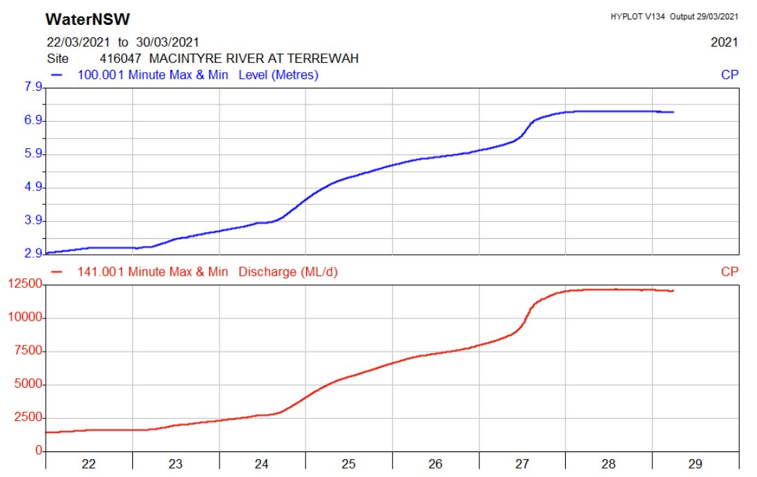
The big flow is still that coming down the Macintyre. Here it is at Terrewah, ~40k below Goondiwindi -- about 120 GL/day:
https://realtimedata.waternsw.com.au?ppbm=416047&rs&1&rscf_org"> https://realtimedata.waternsw.com.au?ppbm=416047&rs&1&rscf_orgrealtimedata.waternsw.com.au/?ppbm=416047&r
https://realtimedata.waternsw.com.au?ppbm=416047&rs&1&rscf_org"> https://realtimedata.waternsw.com.au?ppbm=416047&rs&1&rscf_orgrealtimedata.waternsw.com.au/?ppbm=416047&r
This flow will make it to the Murray now I think. The last Baaka flow to do that (just barely) was in 2016, when the flood in the Macintyre was of similar magnitude. Before that, 2012-13.
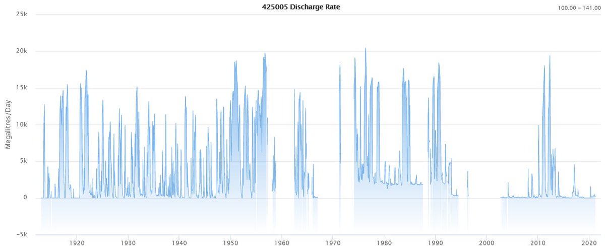
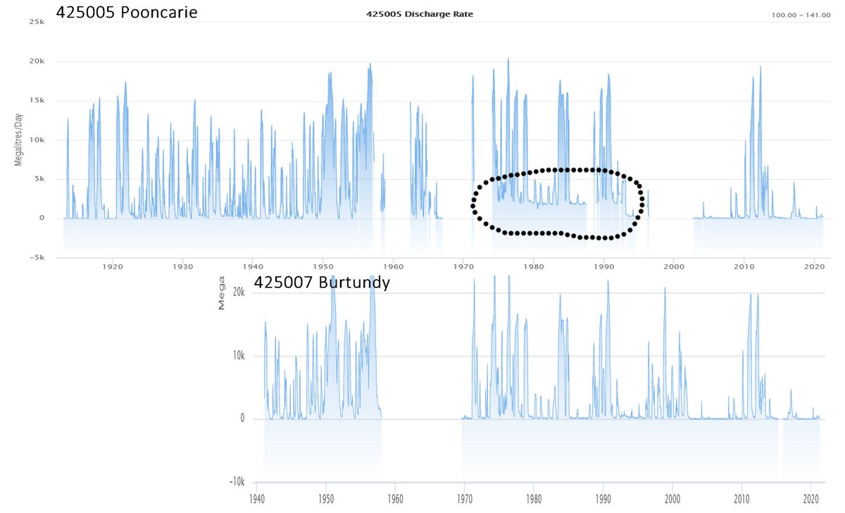
Baaka-Darling at Pooncarie, upstream of the Murray River confluence. Note the long-term decline.
There may be a historical datum/rating issue with this gauge (1974-1993 appears offset), but even allowing for that, once-common flow events have vanished.
https://realtimedata.waternsw.com.au?ppbm=425005|425_DARLING|SURFACE_WATER&rs&1&rscf_org"> https://realtimedata.waternsw.com.au?ppbm=425005|425_DARLING|SURFACE_WATER&rs&1&rscf_orgrealtimedata.waternsw.com.au/?ppbm=425005|4
(Guessing this was a long-term channel blockage of some kind, because it resolved in real-time with the gauge operating, Jan-Feb 1993, with a nice clear exponential recession. But proper selection of gauge ratings ought to have corrected it in the flow record.)
(Streamgauges do not measure flow directly; they measure water level. Flow is obtained from a local correlation called a & #39;rating curve& #39;. That is constructed from multiple point measurements of flow and level over many years. Getting it all right is an art.)
But up the top, pics... https://twitter.com/LucyThack/status/1376751787537920002?s=20">https://twitter.com/LucyThack...
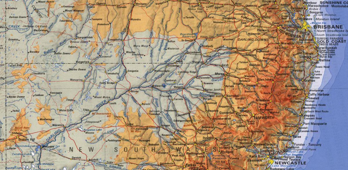
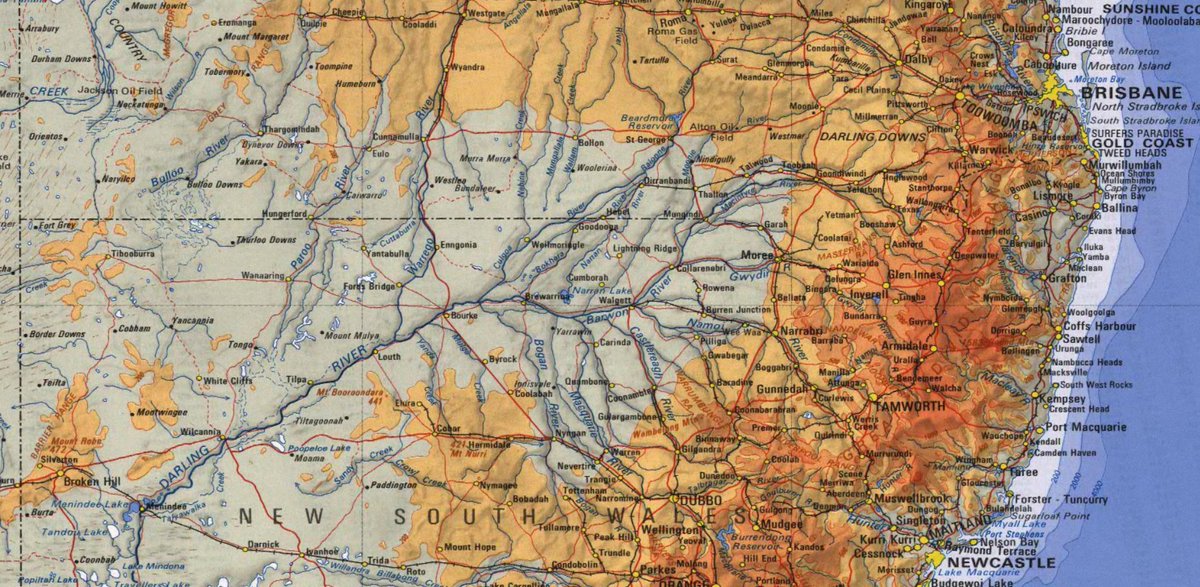
The Barwon is the next below the Macintyre in the European naming chain applied to the Baaka. Along the border rivers it goes: Dumaresq, Macintyre, Barwon, Darling. Down the Queensland chain, it& #39;s: Condamine, Balonne, Bokhara/Culgoa, Barwon, Darling. A map helps:
The water now at Walgett is from the Mehi (Gwydir) and Namoi. As Lucy says, a bigger flood is coming ... down the Macintyre.
A repeat event? Not yet; at +126 hours uncertainty is still high. Also this isn& #39;t as wet; it lacks the north-westerly moisture feed.
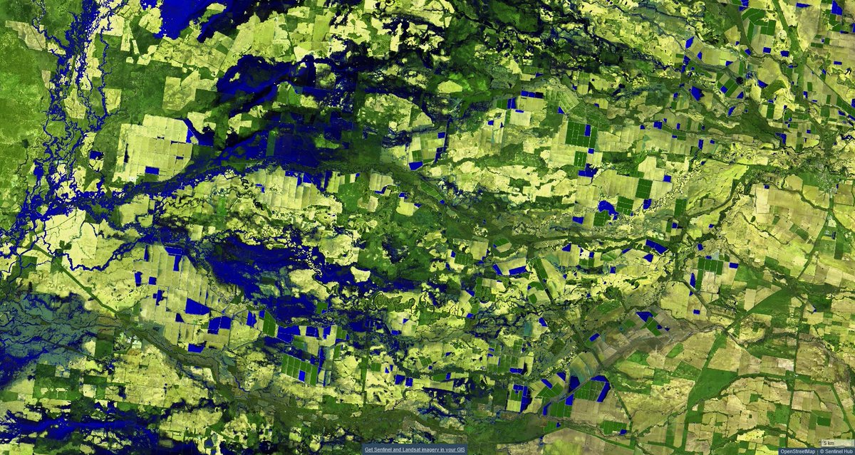
Mungindi to Walgett yesterday morning. Looks impressive, but isn& #39;t all that big really. False colour infrared; surface water is dark blue.
https://apps.sentinel-hub.com/sentinel-playground/?source=S2L2A&lat=-29.389952936381423&lng=148.56536865234375&zoom=10&preset=4_FALSE_COLOR__URBAN&layers=B01,B02,B03&maxcc=20&gain=1.0&gamma=1.0&time=2020-10-01%7C2021-04-03&atmFilter=&showDates=false">https://apps.sentinel-hub.com/sentinel-...
https://apps.sentinel-hub.com/sentinel-playground/?source=S2L2A&lat=-29.389952936381423&lng=148.56536865234375&zoom=10&preset=4_FALSE_COLOR__URBAN&layers=B01,B02,B03&maxcc=20&gain=1.0&gamma=1.0&time=2020-10-01%7C2021-04-03&atmFilter=&showDates=false">https://apps.sentinel-hub.com/sentinel-...
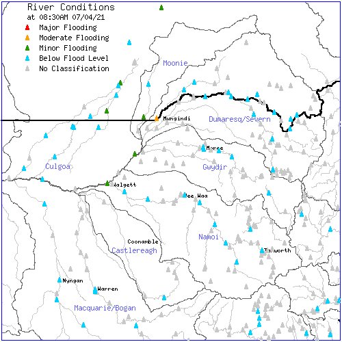
The Baaka flow is resolving now, mostly at only minor flood levels: http://bom.gov.au/nsw/flood/northwest.shtml">https://bom.gov.au/nsw/flood...
That& #39;s despite this being only millimetres below a record flood in Moree. Lots of water is left behind in huge private off-stream storages down the Mehi and Moomin, as is now the thing (Gwydir Valley ... & #39;don& #39;t mention the cotton-suckers& #39;). Moree, right; Baaka-Barwon, left:
So the repeat event didn& #39;t ... repeat (came here instead, sick of it, stuff& #39;s now dying from *too much* rain). We have one orange triangle at Mungindi, which made the national news this morning. Is not nothing.
Most of the Northern Basin private cotton-water storages are now pretty full (those on the Balonne-Culgoa aren& #39;t; maybe half). Going to be an interesting opportunity to do some estimates and comparisons this winter. (Water for cotton is now in storage until spring.)
Via Stuart. https://www.theland.com.au/story/7199197/between-400-and-600gl-to-hit-menindee-lakes/">https://www.theland.com.au/story/719...
"Lost..."
"& #39;A significant volume of water can be lost between Walgett and Boorooma and downstream of Bourke,& #39; it said."
"& #39;A significant volume of water can be lost between Walgett and Boorooma and downstream of Bourke,& #39; it said."
"...Allocations"
"The size of the inflows will ultimately decide whether water is diverted into Lake Menindee or passed through the Lakes system to count towards NSW Murray general security allocations."
"The size of the inflows will ultimately decide whether water is diverted into Lake Menindee or passed through the Lakes system to count towards NSW Murray general security allocations."
Does no one notice the mindset? Really? This is an irrigation ditch, not our greatest inland river.
The flood in the Baaka-Barwon-Darling has now passed Walgett (centre of image) and is headed to Brewarrina (beyond left edge).
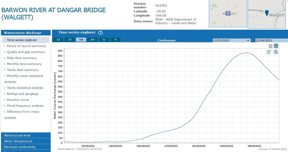
Rise and fall at Walgett. Nothing happens quickly in these rivers.
What is the flow volume? This gauge on Dangar Bridge just below Walgett (Kamilaroi Highway) seems to see most of the flow (other gauges may miss a bit of overbank flow): http://www.bom.gov.au/waterdata/ ">https://www.bom.gov.au/waterdata...
If the hydrograph is symmetrical*, that is going to be about 1100 GL all up.
(* Won& #39;t be -- the tail will be longer, so the aggregate flow will be a little higher than this estimate.)
(* Won& #39;t be -- the tail will be longer, so the aggregate flow will be a little higher than this estimate.)
Yet the NSW Government is only expecting 400-600 GL to reach Menindee. What happens to the rest? Channel filling, shallow aquifer filling and extraction to private irrigation storages. But official estimates have been conservative in the past, will be this time too, I think.
Shallow aquifers are empty because people pumped them for irrigation water, mostly. River-connected aquifers constitute an often overlooked element of water extraction.
There& #39;s also a second peak, currently still in the Macintyre River at Boomi, but it& #39;s much smaller. Private irrigation storages up there are all full; going to be a bumper season.
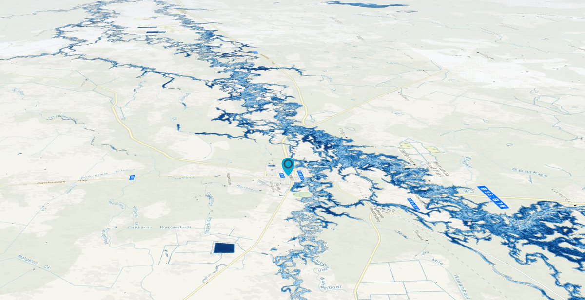
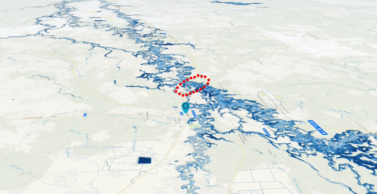
Here& #39;s a nice 3D view of the Baaka-Barwon flood at Walgett (marked, looking downstream) on the 7 April, via Geoscience Australia& #39;s National Map service:
#share=s-oxdhQJNzhhCfT3iEhD9UQ2aSIGE">https://nationalmap.gov.au/ #share=s-oxdhQJNzhhCfT3iEhD9UQ2aSIGE">https://nationalmap.gov.au/...
#share=s-oxdhQJNzhhCfT3iEhD9UQ2aSIGE">https://nationalmap.gov.au/ #share=s-oxdhQJNzhhCfT3iEhD9UQ2aSIGE">https://nationalmap.gov.au/...
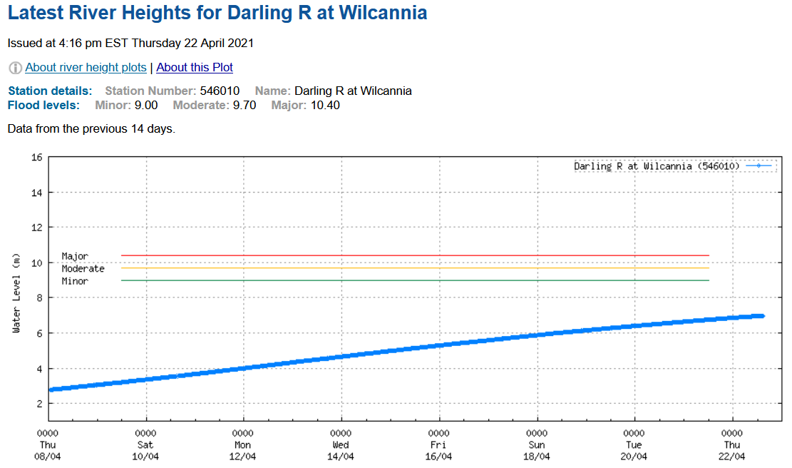
Rising now at Wilcannia.
http://www.bom.gov.au/fwo/IDN60238/IDN60238.546010.plt.shtml">https://www.bom.gov.au/fwo/IDN60...
http://www.bom.gov.au/fwo/IDN60238/IDN60238.546010.plt.shtml">https://www.bom.gov.au/fwo/IDN60...
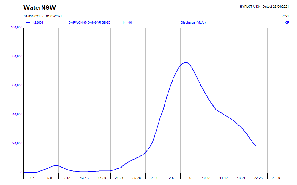
The flood hydrograph is now nearly complete at Walgett (below). The total flow for the event so far is 1240 GL, with a bit more to come. It& #39;s going to tally about 1300 GL all up.
https://realtimedata.waternsw.com.au?ppbm=422001&rs&1&rscf_org"> https://realtimedata.waternsw.com.au?ppbm=422001&rs&1&rscf_orgrealtimedata.waternsw.com.au/?ppbm=422001&r
https://realtimedata.waternsw.com.au?ppbm=422001&rs&1&rscf_org"> https://realtimedata.waternsw.com.au?ppbm=422001&rs&1&rscf_orgrealtimedata.waternsw.com.au/?ppbm=422001&r
Note that the total volume taken into public and private storage from this event is probably over 1000 GL*, so only around half of the available water is making it to the lower Baaka-Darling.
(* We& #39;ll estimate that properly soon; Cubbie Station alone has taken about 60 GL.)
(* We& #39;ll estimate that properly soon; Cubbie Station alone has taken about 60 GL.)
Bourke: https://twitter.com/nathmorris/status/1386640876097523714?s=19">https://twitter.com/nathmorri...
Nice pics. https://twitter.com/GeoscienceAus/status/1387293510508888066?s=20">https://twitter.com/Geoscienc...
Actually not a real lot has happened yet (natural colour, from: https://apps.sentinel-hub.com/eo-browser/?zoom=11&lat=-32.28974&lng=142.41714&themeId=DEFAULT-THEME&datasetId=S2L2A&fromTime=2021-04-23T00%3A00%3A00.000Z&toTime=2021-04-23T23%3A59%3A59.999Z&layerId=1_TRUE_COLOR&visualizationUrl=https%3A%2F%2Fservices.sentinel-hub.com%2Fogc%2Fwms%2Fbd86bcc0-f318-402b-a145-015f85b9427e):">https://apps.sentinel-hub.com/eo-browse...
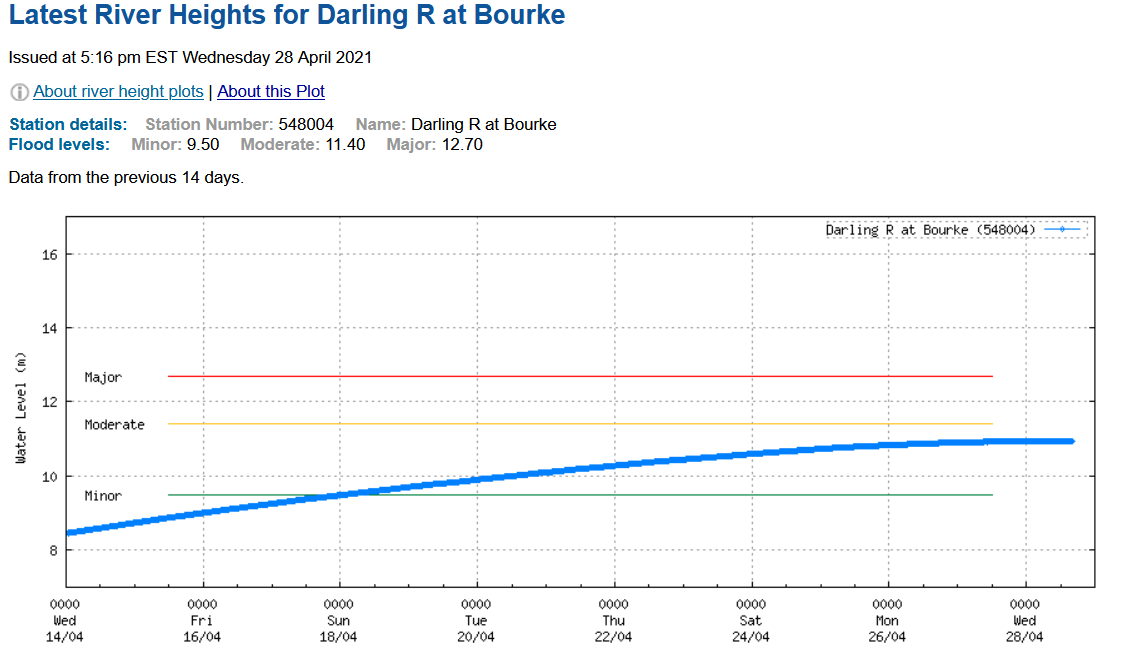
The main flow is only just peaking at Bourke, 400 km upstream (straight-line), so there& #39;s a long long way to go.
http://www.bom.gov.au/fwo/IDN60238/IDN60238.548004.plt.shtml">https://www.bom.gov.au/fwo/IDN60...
http://www.bom.gov.au/fwo/IDN60238/IDN60238.548004.plt.shtml">https://www.bom.gov.au/fwo/IDN60...
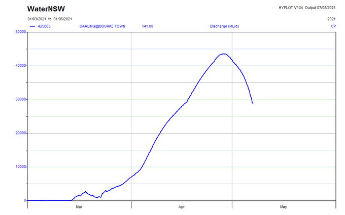
The hydrograph is now nearing completion at Bourke. Wondering what the flow total will be there (remembering that there will have been both natural & #39;losses& #39; and cotton sucker extraction all along the way).
https://realtimedata.waternsw.com.au?ppbm=425003|425_DARLING|SURFACE_WATER&rs&1&rscf_org"> https://realtimedata.waternsw.com.au?ppbm=425003|425_DARLING|SURFACE_WATER&rs&1&rscf_orgrealtimedata.waternsw.com.au/?ppbm=425003|4
https://realtimedata.waternsw.com.au?ppbm=425003|425_DARLING|SURFACE_WATER&rs&1&rscf_org"> https://realtimedata.waternsw.com.au?ppbm=425003|425_DARLING|SURFACE_WATER&rs&1&rscf_orgrealtimedata.waternsw.com.au/?ppbm=425003|4
Here& #39;s the flow nearing the peak at Bourke late last month, looking downstream. The gauge is in town; might miss a bit of water flowing down the Big Billabong anabranch, but not much at this flow level. Note the private cotton-water storages, now full.
#share=s-m2WXVoLPS4vzMorxr65NsEaP5mO">https://nationalmap.gov.au/ #share=s-m2WXVoLPS4vzMorxr65NsEaP5mO">https://nationalmap.gov.au/...
#share=s-m2WXVoLPS4vzMorxr65NsEaP5mO">https://nationalmap.gov.au/ #share=s-m2WXVoLPS4vzMorxr65NsEaP5mO">https://nationalmap.gov.au/...
There isn& #39;t much irrigated cotton growing beyond Bourke, so that& #39;s about it now for irrigation extraction. (Used to be some down at Lake Tandou at Menindee, but that& #39;s been bought out.)
The total flow for the event so far at the Bourke town gauge is 1130 GL. If the hydrograph were symmetrical from here (won& #39;t be), the total flow would be about 1400 GL. Compare the estimated total flow upstream at Walgett, which was ~1300 GL.
We subtracted channel filling, channel losses and irrigation extraction, and got a higher total flow …huh? 1. These gauges are not precise; at these levels ±10% would be doing well. 2. We also added flow from the Castlereagh, Macquarie, Bokhara, Culgoa and Bogan R. tributaries
It now looks like more than 1000 GL will reach Menindee (is there a revised official estimate?). The capacity of the & #39;engineered& #39; lake system there is 1730 GL, with 645 GL already in storage, so the whole flow could presumably be diverted*.
...With ~zero resulting natural flow in the rivers downstream to the Murray (there& #39;s two main branches).
(* Not sure about the control structure levels. Can the lakes be filled to 100% with zero river flow & #39;bypassing& #39; them?)
(* Not sure about the control structure levels. Can the lakes be filled to 100% with zero river flow & #39;bypassing& #39; them?)
This is all highly awkward for the NSW government, because once the Menindee Lakes storage level rises above 640 GL (it just did), control of the lakes passes by agreement to the Murray-Darling Basin Authority, and stays with it until the storage drops back below 480 GL.
What in effect happened was the NSW Government traded some Baaka-Darling water for Murrumbidgee-Murray water. South Australia gets the Menindee-Baaka and NSW irrigators take the Murray.
Which is not necessarily a terrible thing (at the moment) because means the MDBA now controls the flow in the lower Darling (and the Great Anabranch), and it has rather more demonstrated interest in river health than Berejiklian& #39;s Department of Planning, Industry and Environment.
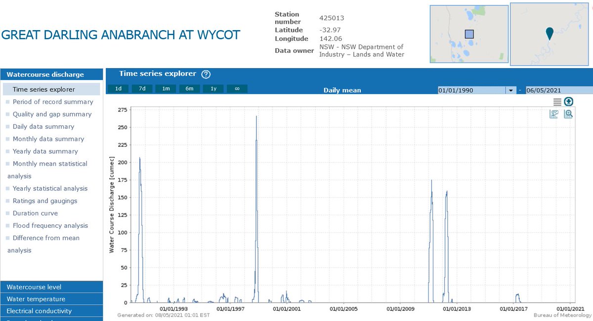
When did the & #39;Great Darling Anabranch& #39; (below Menindee) last see a flow? I suspect it& #39;s a very long time ... yep, is. Another major inland river system we& #39;ve totally f^%ked, and no on notices or cares:
http://www.bom.gov.au/waterdata/ ">https://www.bom.gov.au/waterdata...
http://www.bom.gov.au/waterdata/ ">https://www.bom.gov.au/waterdata...
BTW, seems all those little (imposed, artificial) low flows in the Darling Anabranch up to 2002 weren& #39;t great for river health either. *Unlike* the Baaka-Darling main channel, it& #39;s meant to be an ephemeral system. https://researchoutput.csu.edu.au/en/publications/darling-anabranch-adaptive-management-monitoring-program-phase-1-">https://researchoutput.csu.edu.au/en/public...
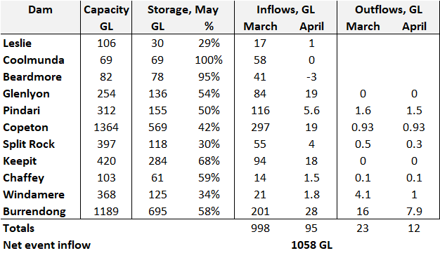
Up-thread some, I wrote "the total volume taken into public and private storage from this event is probably over 1000 GL", meaning about half the potential flow in the Baaka-Darling from this event has instead been impounded, mostly for future cotton irrigation...
...And you thought I was exaggerating, didn& #39;t you. Except, here& #39;s the data, just for the public dams in the catchment. That tallies to 1058 GL taken from the potential downstream flow:
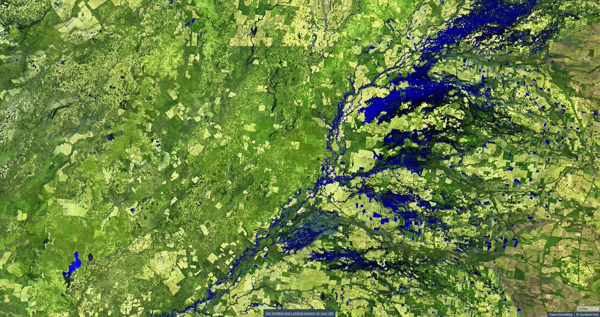
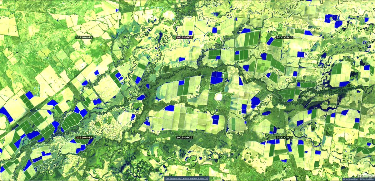
But there& #39;s more. What about all these, up on the Macintyre-Barwon below Goondiwindi -- private off-stream cotton-water storages filled with water sucked from the river flow event (infrared image, blue = surface water). Note the scale bar, bottom right, 5 km.
They were mostly empty just in February (below). How much water is that? We do not know. Qld and especially NSW regulators don& #39;t even reliably know how many of these things there are, let alone how much water is in them at any given time.
We already estimated the volume taken into private storage at one property, Cubbie Station, checked by upstream vs downstream river flow records. Answer: about 60 GL, and Cubbie didn& #39;t even see most of this flow event (it bypassed it). https://twitter.com/Gergyl/status/1377175788173230086?s=20">https://twitter.com/Gergyl/st...
Others more learned than I have made a careful estimate by satellite remote sensing, just of the NSW private storages. That (below) says ~1400 GL, *just in NSW Baaka-Darling catchment* (the image above is cross-border; about half NSW, half Qld)... https://twitter.com/SlatteryJohnso/status/1366260318851059712?s=20">https://twitter.com/SlatteryJ...
Add the similar storages in Queensland and the total private cotton-water storage capacity is well over 2000 GL, probably nearer 2500 GL (Cubbie alone can store 460 GL).
But those are not all full of course (Cubbie is not), and they were not all empty at the start of the event. Even if only half of the available private storage volume was filled by sucking from the flow event (it& #39;s more than that), that would be at least another 1000 GL taken.
So, very conservatively, 2000 GL was taken into public plus private storage from this flow event. Compare the estimated downstream-of-cotton Baaka-Darling flow of 1400 GL.
Extraction and impoundment took ~60% of the potential 2021 flow in the Baaka-Darling, mostly for cotton irrigation. Only 40% proceeded to the lower river.
Interestingly my estimate for the smaller March 2020 flow event yielded a similar split: 60% to storage (mostly for cotton irrigation) and just 40% to the river downstream: https://twitter.com/Gergyl/status/1249966082724519941?s=20">https://twitter.com/Gergyl/st...
Why do you never hear those numbers reported? Inconvenient, one assumes.
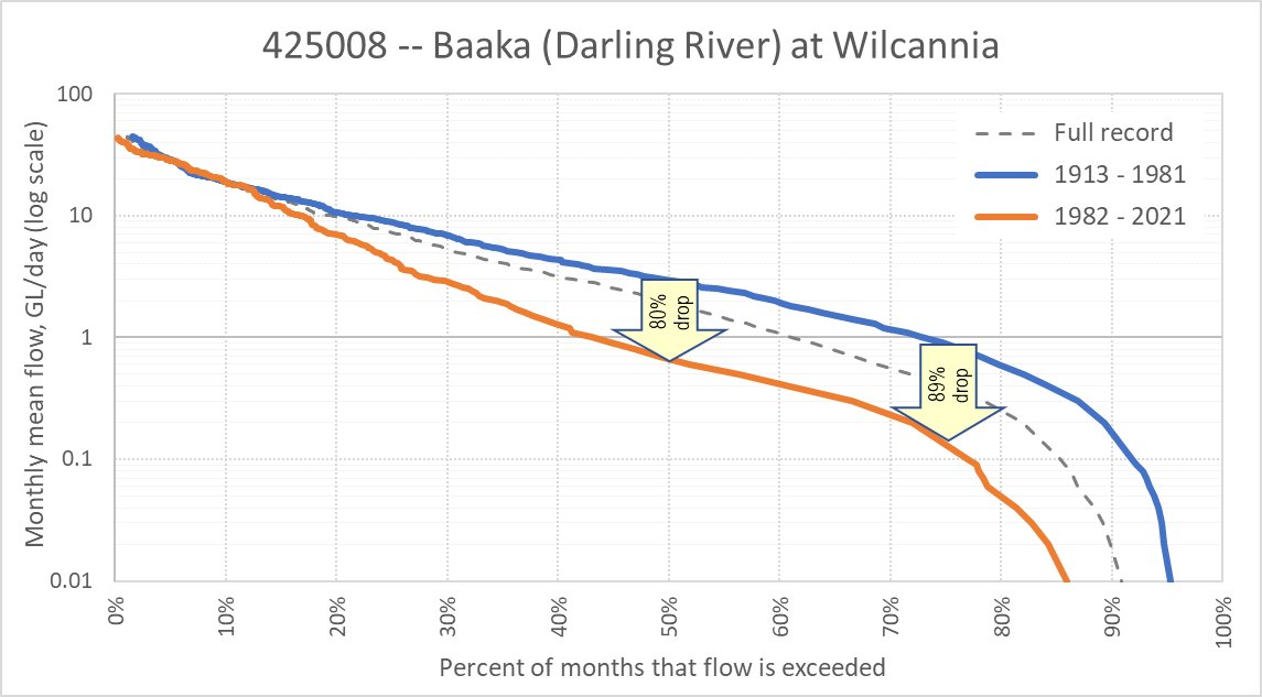
The flow in the Baaka-Darling has collapsed. Below are segmental monthly flow-duration curves for the Wilcannia gauge (note log scale) -- the median flow over the last 40 years is *eighty percent* (80%) lower than in the preceding ~70 years:
Eighty percent decline ... how is this not huge news? And the lower quartile flow is 89% lower -- just a tenth of what it for much of last century was. All down to climate change? No doubt the cotton industry finds it convenient that you think that.

 Read on Twitter