[Doklam]
This looks more like over-head shelter covering a stretch of the road than a tunnel. So, why are we using the word & #39;tunnel& #39;? It has a very different connotations and I won& #39;t recommend such a casual usage. @VishnuNDTV https://twitter.com/VishnuNDTV/status/1325820615526211584">https://twitter.com/VishnuNDT...
This looks more like over-head shelter covering a stretch of the road than a tunnel. So, why are we using the word & #39;tunnel& #39;? It has a very different connotations and I won& #39;t recommend such a casual usage. @VishnuNDTV https://twitter.com/VishnuNDTV/status/1325820615526211584">https://twitter.com/VishnuNDT...
Since Doklam refuses to die down, putting together tweets from 2017 onward on the subject for sake of continuity.
From July 2017, when the situation had just exploded into the national scene. https://twitter.com/KesariDhwaj/status/881465761151164416?s=20">https://twitter.com/KesariDhw...
From October 2017 when we had reached a stalemate with respect to the ground situation - https://twitter.com/KesariDhwaj/status/917155880746967040?s=20">https://twitter.com/KesariDhw...
Thread explaining my POV on the stand-off and some takeaways https://twitter.com/KesariDhwaj/status/918036724269268994?s=20">https://twitter.com/KesariDhw...
2017 report in India Today by @SandeepUnnithan https://twitter.com/SandeepUnnithan/status/914384720879742977?s=20">https://twitter.com/SandeepUn...
Analysis of some serious guffaws done by our English media with their usual sensationalist reporting. https://twitter.com/KesariDhwaj/status/923527794402869249?s=20">https://twitter.com/KesariDhw...
https://twitter.com/KesariDhwaj/status/923553281586036736?s=20">https://twitter.com/KesariDhw...
https://twitter.com/KesariDhwaj/status/925229675139305472?s=20">https://twitter.com/KesariDhw...
Sub-Thread on Chinese infra development on Doklam. https://twitter.com/KesariDhwaj/status/953867169179222016?s=20">https://twitter.com/KesariDhw...
My article in @Opindia where I had questioned some sensational claims made by The Print. https://twitter.com/OpIndia_com/status/977460854143594496?s=20">https://twitter.com/OpIndia_c...
https://twitter.com/KesariDhwaj/status/1262589477786025987?s=20">https://twitter.com/KesariDhw...
- Report by @VishnuNDTV on new Chinese infra 10km beyond China-Bhutan border.
- Well, Chinese have built it on their claimed/disputed area with Bhutan
- Let me explain the larger China-Bhutan area dispute in this region which no one has studied so far. https://www.ndtv.com/india-news/exclusive-satellite-images-hint-at-renewed-china-threat-in-doklam-2328660">https://www.ndtv.com/india-new...
China-Bhutan dispute in Doklam Area
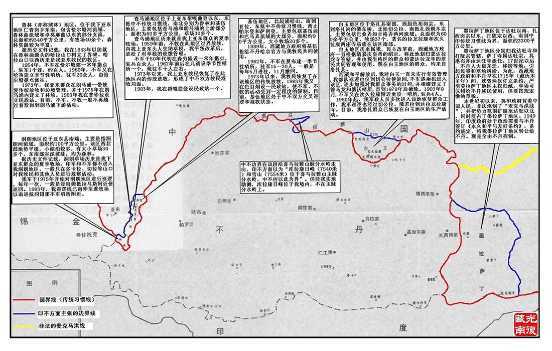
1. Map-01: Chinese maps which gives details of all disputed areas with Bhutan.
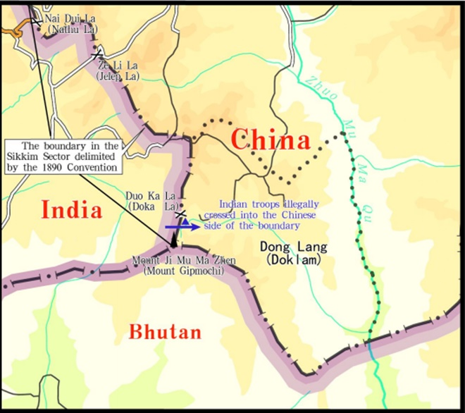
2. Map-02: Zoom-in to Doklam area.
- Look at the blue & red line.
- Blue line is border as per Bhutan
- Red line is border as per China
3. Blue line is the border +
1. Map-01: Chinese maps which gives details of all disputed areas with Bhutan.
2. Map-02: Zoom-in to Doklam area.
- Look at the blue & red line.
- Blue line is border as per Bhutan
- Red line is border as per China
3. Blue line is the border +
+ that you see on Google Earth.
4. So, when when measured from here, the new & #39;village& #39; reported by @VishnuNDTV is beyond the China-Bhutan border.
5. But as per the Chinese? Well, surprise, surprise! Its on their side of disputed border! Sounds familiar? LAC anyone?
+
4. So, when when measured from here, the new & #39;village& #39; reported by @VishnuNDTV is beyond the China-Bhutan border.
5. But as per the Chinese? Well, surprise, surprise! Its on their side of disputed border! Sounds familiar? LAC anyone?
+
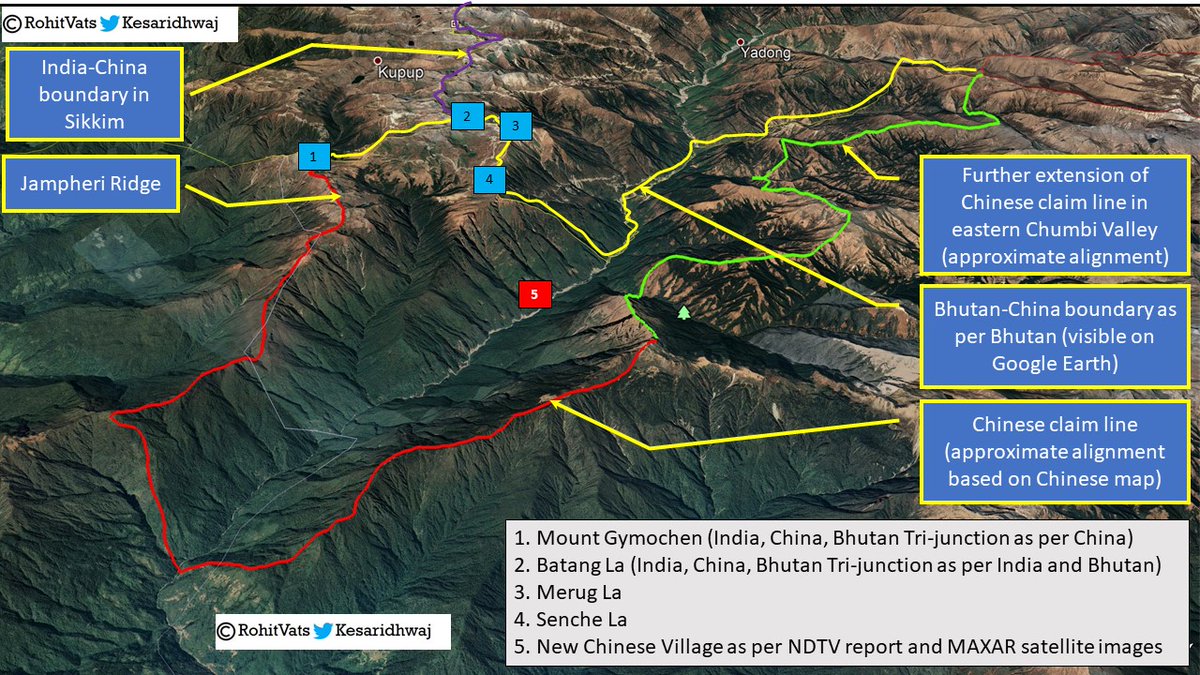
6. If you look at the previous and below attached Chinese border alignment, it runs west from Tri-Junction at Mount Gimpoche, along the Jampheri Ridge and then down towards the Amo-Chu river.
7. Then, rather than following Amo-Chu river northwards, it moves further west +
7. Then, rather than following Amo-Chu river northwards, it moves further west +
+ and runs along the ridge-line to west of Amo-Chu river.
8. From here, it moves north along a south-north ridgeline, thereby expanding Chinese claim in this sector.
9. Attached map shows approximate alignment of Chinese claim line as shown in Map 1,2&3, drawn on Google Earth+
8. From here, it moves north along a south-north ridgeline, thereby expanding Chinese claim in this sector.
9. Attached map shows approximate alignment of Chinese claim line as shown in Map 1,2&3, drawn on Google Earth+
10. Well, as you can see, this new village is perfectly within the Chinese side of the & #39;disputed& #39; area.
11. BTW, do check how the Chinese claim line moves south-east along the Jampheri ridge line.
12. Now you know how Jampheri ridge line is part of a larger border issue with the+
11. BTW, do check how the Chinese claim line moves south-east along the Jampheri ridge line.
12. Now you know how Jampheri ridge line is part of a larger border issue with the+
+ Bhutanese.
13. W/O Jampheri ridge, Chinese claim in this entire area cannot be complete, they will always lack the much sought after depth and India can dominate their positions along the Amo-Chu river.
13. W/O Jampheri ridge, Chinese claim in this entire area cannot be complete, they will always lack the much sought after depth and India can dominate their positions along the Amo-Chu river.

 Read on Twitter


