This week I released a 60-minute episode of @valley101pod on how interstate highways affected segregation in Phoenix. I read a book about government policies that segregated American cities. Highways were one way. I wondered if that happened in PHX. https://www.amazon.com/Color-Law-Forgotten-Government-Segregated/dp/1631492853">https://www.amazon.com/Color-Law...  https://abs.twimg.com/emoji/v2/... draggable="false" alt="⬇️" title="Pfeil nach unten" aria-label="Emoji: Pfeil nach unten">
President Dwight D. Eisenhower signed the 1956 Interstate Highway Act during the Cold War. They were billed as crucial to national security in case cities had to evacuate. Here& #39;s a commercial promoting the project. Immediately, residents were concerned.  https://abs.twimg.com/emoji/v2/... draggable="false" alt="⬇️" title="Pfeil nach unten" aria-label="Emoji: Pfeil nach unten"> https://archive.org/details/62784WellTakeTheHighRoad">https://archive.org/details/6...
The highways cut through neighborhoods & demolished homes. Some cities placed highways through "slum areas," razing minority neighborhoods. Civil rights activists were clear in their feelings of being targeted. This increased segregation in some cities.  https://abs.twimg.com/emoji/v2/... draggable="false" alt="⬇️" title="Pfeil nach unten" aria-label="Emoji: Pfeil nach unten"> https://www.youtube.com/watch?v=T8Abhj17kYU">https://www.youtube.com/watch...
In Phoenix, segregation was already deeply ingrained, through things like redlining and restrictive covenants. An old @valley101pod episode from @kailawhite explains this. So the highways didn& #39;t create segregation here. But they DID have an effect.  https://abs.twimg.com/emoji/v2/... draggable="false" alt="⬇️" title="Pfeil nach unten" aria-label="Emoji: Pfeil nach unten"> https://www.azcentral.com/story/news/local/arizona/2019/06/10/valley-101-podcast-phoenix-history-redlining-and-segregation/1230052001/">https://www.azcentral.com/story/new...
Phoenix& #39;s divide was demarcated by Van Buren Street. The story dates back to the 1890s. At that time, people of various races more or less lived together along the Salt River. But then the river kept flooding. Those who could afford to move relocated north of Van Buren Street.  https://abs.twimg.com/emoji/v2/... draggable="false" alt="⬇️" title="Pfeil nach unten" aria-label="Emoji: Pfeil nach unten">
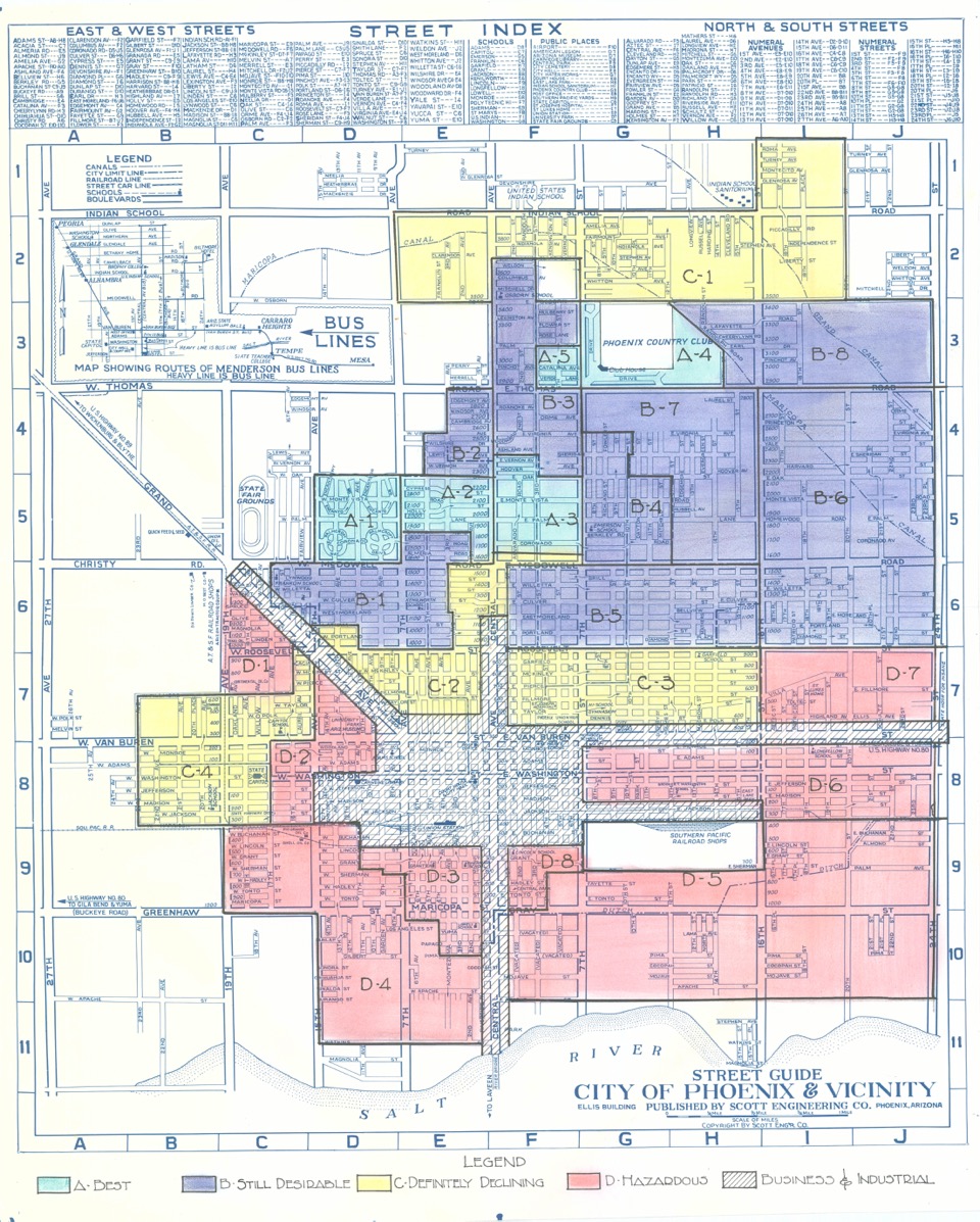
These were mostly white people. And in the decades that followed, segregation intensified through real-estate practices, public schooling, bans on interracial marriage, etc. Btw, here& #39;s a map of redlined Phoenix.
Anyway, the 1956 act created interstates 10 & 17. The drama came in the downtown area. When I examined the timeline and resident backlash, one thing became clear: where white residents reacted, the government responded. For minority communities? Not so much.  https://abs.twimg.com/emoji/v2/... draggable="false" alt="⬇️" title="Pfeil nach unten" aria-label="Emoji: Pfeil nach unten">
In 1965, Sen. Carl Hayden, a Democrat, lobbied on behalf of predominantly white communities in west Phoenix to shift the I-10 to be placed closer to McDowell. He wanted it to be close enough to benefit them. He won. This helped spur growth in places like Tolleson and Goodyear. https://abs.twimg.com/emoji/v2/... draggable="false" alt="⬇️" title="Pfeil nach unten" aria-label="Emoji: Pfeil nach unten">
But this win complicated paths in downtown. First, I-10 was suppose to intersect I-17 in south Phoenix at Durango Street. What would they do there now? Also, this shift north meant I-10 would bisect predominantly white neighborhoods like Roosevelt and Coronado. Drama ahead.  https://abs.twimg.com/emoji/v2/... draggable="false" alt="⬇️" title="Pfeil nach unten" aria-label="Emoji: Pfeil nach unten">
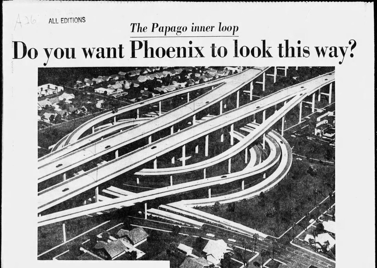
These folks raised hell. People took out billboards to express their displeasure. Communities started fighting for (and winning) historic designation status as a means to fight back. So what did the city do? It proposed a new highway, one that would go 100 feet in the air.  https://abs.twimg.com/emoji/v2/... draggable="false" alt="⬇️" title="Pfeil nach unten" aria-label="Emoji: Pfeil nach unten">
The people essentially said, "No. That& #39;s ugly. That& #39;s expensive." So the city put it to a vote. The city loses. Meanwhile the highway planners are concerned because they need to connect Phoenix to Tucson. (The whole point of the 1956 act.)  https://abs.twimg.com/emoji/v2/... draggable="false" alt="⬇️" title="Pfeil nach unten" aria-label="Emoji: Pfeil nach unten">
At this point they have connected Phoenix to northern cities and to CA. They just need to get to Tucson. They decide to build out the Maricopa Freeway across south Phoenix. It extends from I-17& #39;s Durango Curve to I-10& #39;s Broadway Curve (which heads to Tucson).  https://abs.twimg.com/emoji/v2/... draggable="false" alt="⬇️" title="Pfeil nach unten" aria-label="Emoji: Pfeil nach unten">
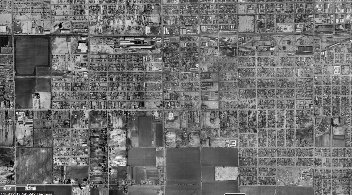
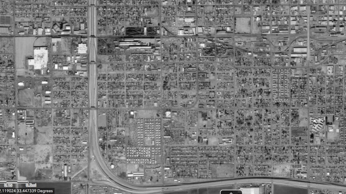
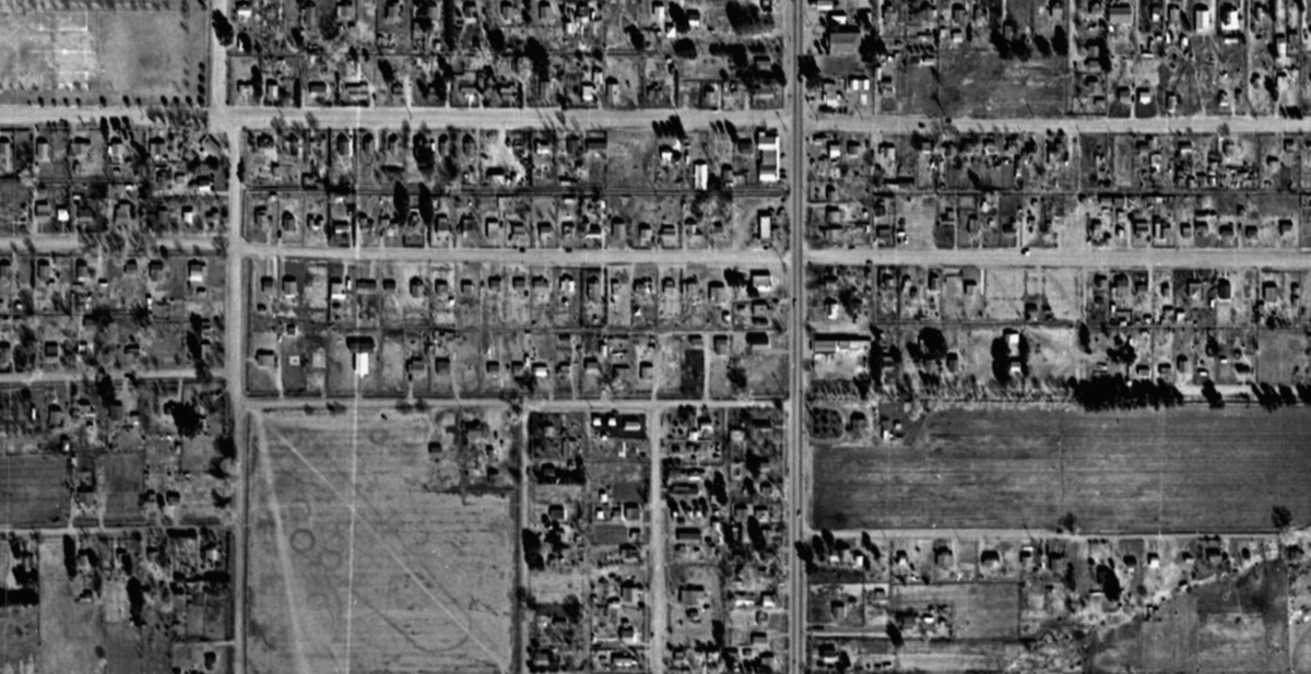
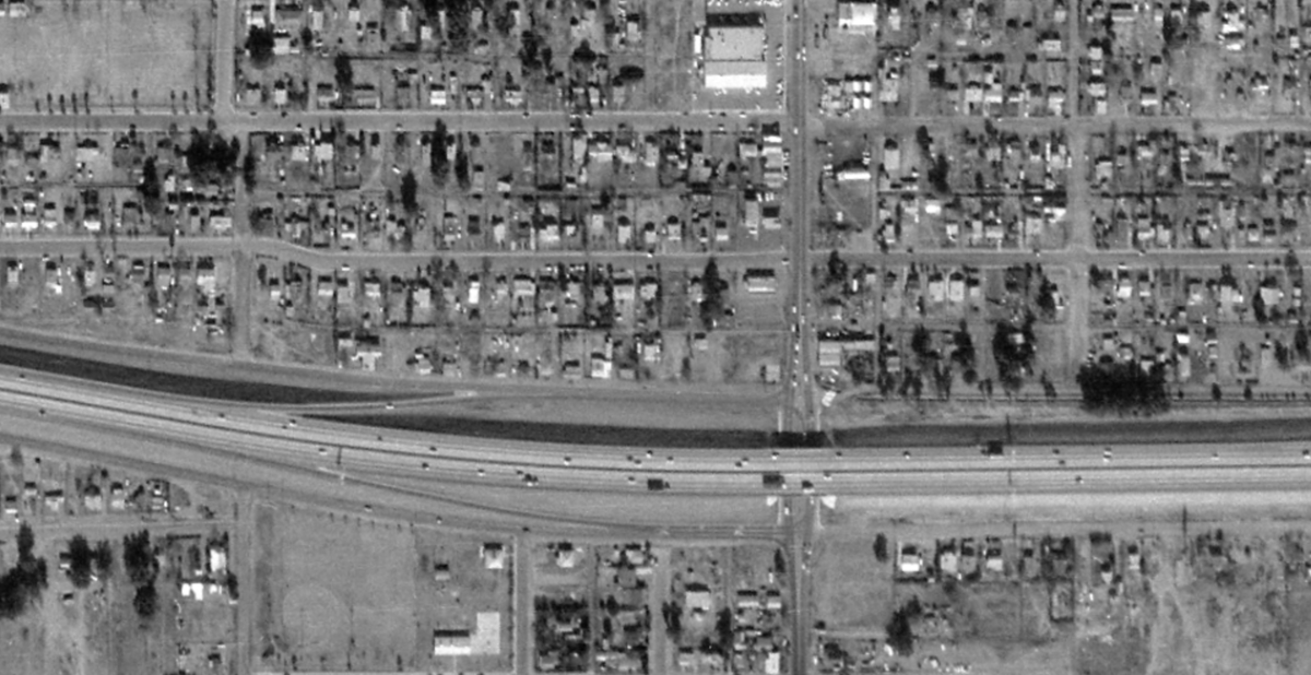
I-17 construction in south Phoenix already demolished homes and divided neighborhoods in Black and Latino communities. I couldn& #39;t find much about any neighborhood opposition, but then again they weren& #39;t given much of a say. Here are some before and after screenshots.
The city had been buying up property for this years in advance. The Black newspapers didn& #39;t have the political sway Eugene Pulliam& #39;s Arizona Republic did. And there were no representatives from this area in the city council.
But then the city added the Maricopa Freeway, which added another wall. It decimated historic barrios, some of which got their start in the 1920s! The barrios were places where generations of Latino families grew up. This was a big deal.  https://abs.twimg.com/emoji/v2/... draggable="false" alt="⬇️" title="Pfeil nach unten" aria-label="Emoji: Pfeil nach unten">
These neighborhoods provided support for residents who felt ostracized in other parts of town. Living in close proximity was also a practical choice. The ability to rely on family neighbors to watch kids or help out was a linchpin of barrio life.  https://abs.twimg.com/emoji/v2/... draggable="false" alt="⬇️" title="Pfeil nach unten" aria-label="Emoji: Pfeil nach unten">
Anyway, the barrio residents hated the Maricopa Freeway. It finished in 1971. At this time, the city was still trying to figure out how it was going to finish I-10 through the Roosevelt neighborhood area. The Deck Park Tunnel is finally accepted in 1979. https://www.azcentral.com/story/news/local/phoenix/2019/08/05/why-interstate-10-tunnel-downtown-phoenix-valley-101-podcast/1896995001/">https://www.azcentral.com/story/new...
The Deck Park Tunnel completes the Papago Freeway, which takes I-10 from the west side through the Roosevelt neighborhood area and then bends south at about 20th street to meet up with the Maricopa Freeway. What does this mean for the barrios?  https://abs.twimg.com/emoji/v2/... draggable="false" alt="⬇️" title="Pfeil nach unten" aria-label="Emoji: Pfeil nach unten">
It means they now have a third barrier bounding their community. I-17 / Durango Curve on the west, Maricopa Freeway on the south, and now I-10& #39;s Papago on the east. Why& #39;s this a big deal? Because freeways are considered a "disamenity" according to experts I spoke to.  https://abs.twimg.com/emoji/v2/... draggable="false" alt="⬇️" title="Pfeil nach unten" aria-label="Emoji: Pfeil nach unten">
People want to live close enough to highways to hop on in a 5-minute drive, but not close enough to hear them or be bogged down by the pollution associated with them. When they& #39;re too close, homes lose value and there are health consequences.  https://abs.twimg.com/emoji/v2/... draggable="false" alt="⬇️" title="Pfeil nach unten" aria-label="Emoji: Pfeil nach unten"> https://www.humanecologyreview.org/pastissues/her122/bolingrineskicollins.pdf?links=false">https://www.humanecologyreview.org/pastissue...
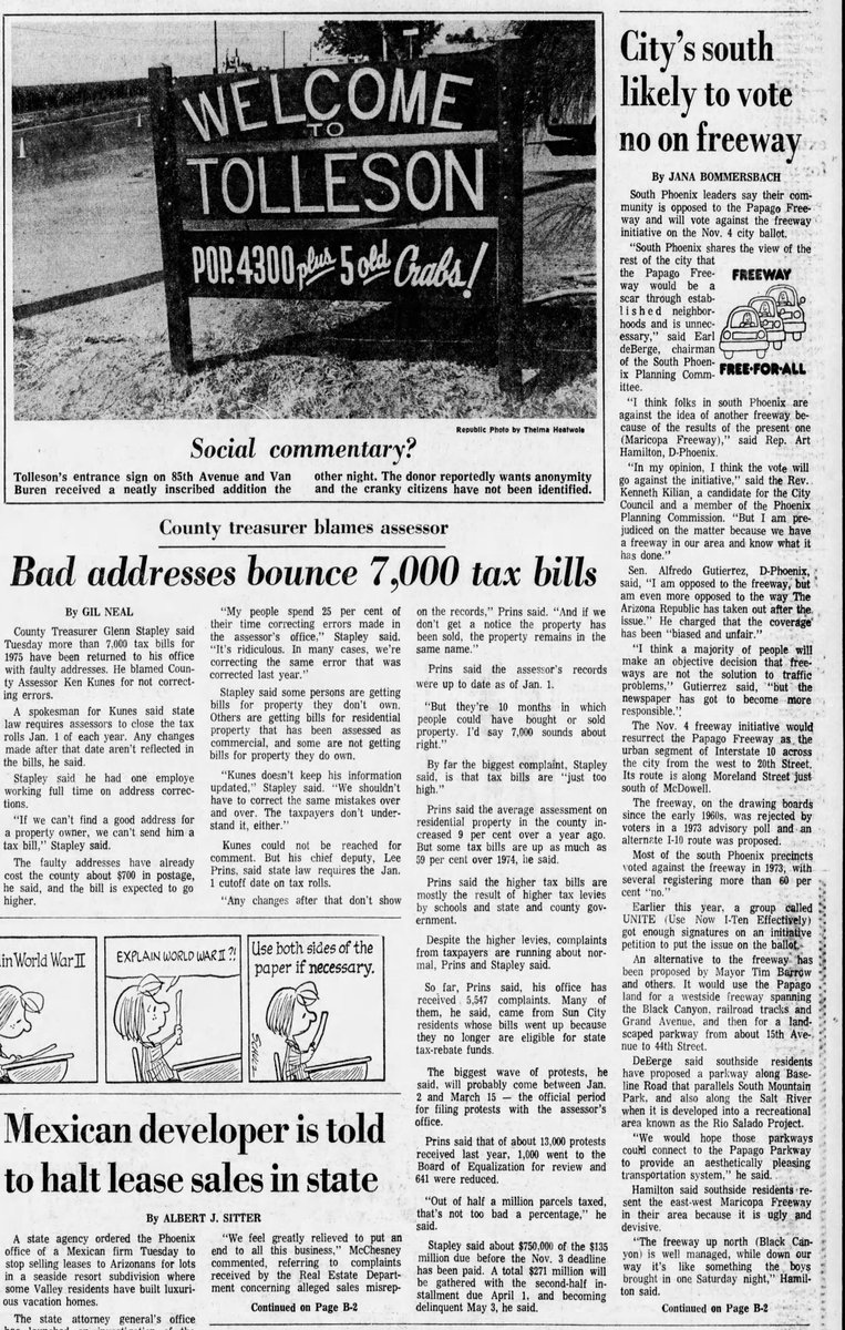
The other major effect highways have is suburbanization. You know how Sen. Hayden wanted I-10 shifted north? That was to spur growth in suburbs like Tolleson. This diverts resources from downtown areas that need it. Here& #39;s a poignant news clip showing that tension.  https://abs.twimg.com/emoji/v2/... draggable="false" alt="⬇️" title="Pfeil nach unten" aria-label="Emoji: Pfeil nach unten">
So what happens to residents of downtown areas? The city compensated people for the loss of their homes if they were demolished. But in south Phx, payouts were very low because the area was considered a transit corridor and was historically undervalued from redlining/stigma.  https://abs.twimg.com/emoji/v2/... draggable="false" alt="⬇️" title="Pfeil nach unten" aria-label="Emoji: Pfeil nach unten">
Ultimately, some south Phoenix residents go homeless, some move into friends and families& #39; homes (accelerating wear and tear), and some take on mortgages to be able to move to other affordable parts of town, like Maryvale, which was by this time aging.  https://abs.twimg.com/emoji/v2/... draggable="false" alt="⬇️" title="Pfeil nach unten" aria-label="Emoji: Pfeil nach unten"> https://www.youtube.com/watch?v=Gw9QX-8nKCg">https://www.youtube.com/watch...
But many barrio families were low income & owned their old homes outright. The new payments were a struggle. Some went homeless again. And that& #39;s pretty much the story. History is important and it deeply affects the present. Listen to my episode:  https://abs.twimg.com/emoji/v2/... draggable="false" alt="🛑" title="Stop sign" aria-label="Emoji: Stop sign"> https://podcasts.apple.com/us/podcast/how-did-interstate-highways-affect-segregation-in-phoenix/id1451650012?i=1000495268600">https://podcasts.apple.com/us/podcas...

 Read on Twitter
 " title="In 1965, Sen. Carl Hayden, a Democrat, lobbied on behalf of predominantly white communities in west Phoenix to shift the I-10 to be placed closer to McDowell. He wanted it to be close enough to benefit them. He won. This helped spur growth in places like Tolleson and Goodyear.https://abs.twimg.com/emoji/v2/... draggable="false" alt="⬇️" title="Pfeil nach unten" aria-label="Emoji: Pfeil nach unten">" class="img-responsive" style="max-width:100%;"/>
 " title="These folks raised hell. People took out billboards to express their displeasure. Communities started fighting for (and winning) historic designation status as a means to fight back. So what did the city do? It proposed a new highway, one that would go 100 feet in the air. https://abs.twimg.com/emoji/v2/... draggable="false" alt="⬇️" title="Pfeil nach unten" aria-label="Emoji: Pfeil nach unten">" class="img-responsive" style="max-width:100%;"/>
 " title="But then the city added the Maricopa Freeway, which added another wall. It decimated historic barrios, some of which got their start in the 1920s! The barrios were places where generations of Latino families grew up. This was a big deal. https://abs.twimg.com/emoji/v2/... draggable="false" alt="⬇️" title="Pfeil nach unten" aria-label="Emoji: Pfeil nach unten">">
 " title="But then the city added the Maricopa Freeway, which added another wall. It decimated historic barrios, some of which got their start in the 1920s! The barrios were places where generations of Latino families grew up. This was a big deal. https://abs.twimg.com/emoji/v2/... draggable="false" alt="⬇️" title="Pfeil nach unten" aria-label="Emoji: Pfeil nach unten">">
 " title="The other major effect highways have is suburbanization. You know how Sen. Hayden wanted I-10 shifted north? That was to spur growth in suburbs like Tolleson. This diverts resources from downtown areas that need it. Here& #39;s a poignant news clip showing that tension. https://abs.twimg.com/emoji/v2/... draggable="false" alt="⬇️" title="Pfeil nach unten" aria-label="Emoji: Pfeil nach unten">" class="img-responsive" style="max-width:100%;"/>


