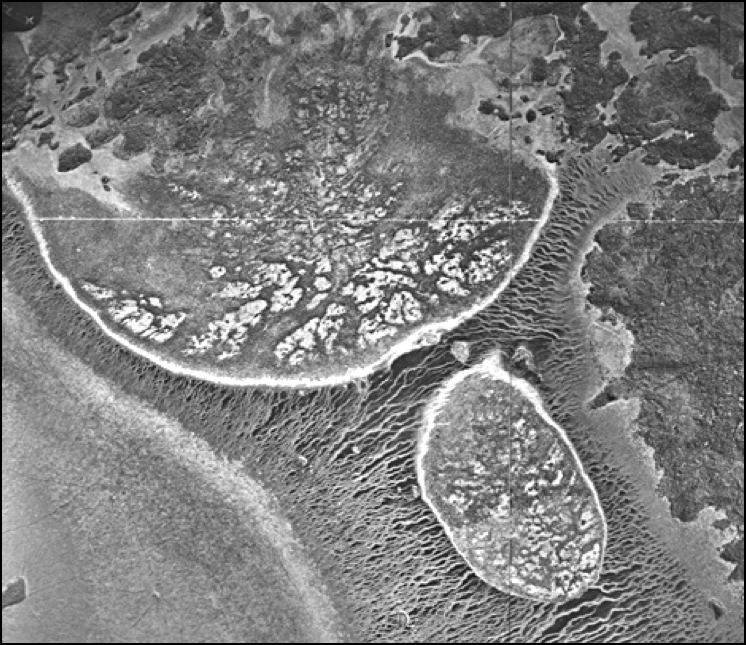
I  https://abs.twimg.com/emoji/v2/... draggable="false" alt="♥️" title="Herz" aria-label="Emoji: Herz"> this image & want to tell you why. Yesterday I asked people to interpret what this was. There is a wealth of information in this single image - it tells us about several hundred yrs of history. A thread on the #PowerOfPattern (with some #BadAssBog thrown in). 1/
What people saw (smallest to largest): virus, pectin strands between cell walls, bone marrow, endosymbiosis, fungal spores, biofilms, small amoeba, giant amoeba, uncaffeinated brain, beach w/ tide, roots, wetland, tundra landscape. All in one image - how cool is that??? 2/
So what the heck is it?? My #PeatTwitter friends nailed it. The B&W image  https://abs.twimg.com/emoji/v2/... draggable="false" alt="👆" title="Rückhand Zeigefinger nach oben" aria-label="Emoji: Rückhand Zeigefinger nach oben"> is from peatlands in boreal Alberta
  https://abs.twimg.com/emoji/v2/... draggable="false" alt="🇨🇦" title="Flagge von Kanada" aria-label="Emoji: Flagge von Kanada">. The bubbles are bog islands and the stripey patterns are created by fen vegetation. But that is just the beginning of this story. 3/
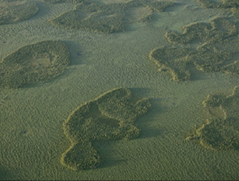
Here is another image of the same type of patterning in peatlands. Can we please take a moment to reflect on the incredible beauty of boreal landscapes? Again, these are bog islands within a larger fen. The bogs are forested - the surface is raised above the wetter fens. 4/
Bog islands often are tear shaped, from the Everglades to the boreal. As water flows around the island, it interacts with vegetation and soil to form the narrow tail. So the shape of the island tells us a lot about the direction and rate of water flow! 5/ https://www.evergladesimagery.com/everglades/communities/communities-tree-islands.html">https://www.evergladesimagery.com/everglade...
Guess where else tear dropped shaped islands occur? Mars! 6/ https://www.wired.com/2011/06/teardrop-shaped-island/">https://www.wired.com/2011/06/t...
Bog islands are #BadAssBogs but let& #39;s focus on the surrounding #FabulousFens. My example above were rich fens in the  https://abs.twimg.com/emoji/v2/... draggable="false" alt="🇨🇦" title="Flagge von Kanada" aria-label="Emoji: Flagge von Kanada"> wetland classification system (my favorite because it is intuitive). Any takers want to guess why rich fens are called rich fens? Creative answers ONLY. 7/
Many think that rich fens are "rich" because they have high nutrient/ion concentrations compared to poor fens. & #39;Tis true but the term was used by DuRietz ~1940 to describe the abundance of diversity indicators in rich fens. So poor fens=biodiversity deserts while rich fens are...
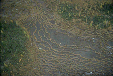
These are patterned rich fens. Look at those strings & flarks! Narrow ribbons of drier vegetation separated by semi-aquatic pools. Don& #39;t fall in! Water flows perpendicular to the strings so we can tell a lot about hydrology just from these patterns. #FabulousFens 9/
In this thread, the shape of #BadAssBog islands & the direction of strings in #FabulousFens hold important lessons. One last pattern to address - the white patches inside the bog islands. Any guesses? Creative answers only. Hint - it involves ghosts. 10/
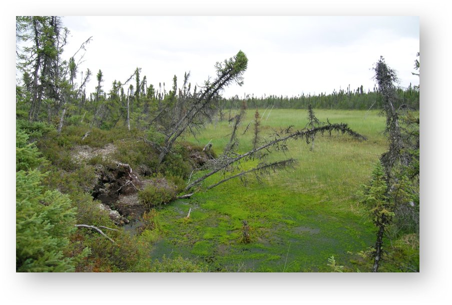
25 yrs ago, Steve Zoltai of @NRCan noticed ghost-like features in air photos of northern peatlands. Were they real or artifacts of imagery? No one knew. Field surveys showed that the white patches inside bog islands were thawing permafrost & they were found all across  https://abs.twimg.com/emoji/v2/... draggable="false" alt="🇨🇦" title="Flagge von Kanada" aria-label="Emoji: Flagge von Kanada">. 11/

 Read on Twitter
 this image & want to tell you why. Yesterday I asked people to interpret what this was. There is a wealth of information in this single image - it tells us about several hundred yrs of history. A thread on the #PowerOfPattern (with some #BadAssBog thrown in). 1/" title="I https://abs.twimg.com/emoji/v2/... draggable="false" alt="♥️" title="Herz" aria-label="Emoji: Herz"> this image & want to tell you why. Yesterday I asked people to interpret what this was. There is a wealth of information in this single image - it tells us about several hundred yrs of history. A thread on the #PowerOfPattern (with some #BadAssBog thrown in). 1/" class="img-responsive" style="max-width:100%;"/>

 wetland classification system (my favorite because it is intuitive). Any takers want to guess why rich fens are called rich fens? Creative answers ONLY. 7/" title="Bog islands are #BadAssBogs but let& #39;s focus on the surrounding #FabulousFens. My example above were rich fens in the https://abs.twimg.com/emoji/v2/... draggable="false" alt="🇨🇦" title="Flagge von Kanada" aria-label="Emoji: Flagge von Kanada"> wetland classification system (my favorite because it is intuitive). Any takers want to guess why rich fens are called rich fens? Creative answers ONLY. 7/" class="img-responsive" style="max-width:100%;"/>


