
 Read on Twitter
#BREAKING
New evacuation orders issued for Juniper Hills and Devil& #39;s Punchbowl as firefighters try to contain massive #BobcatFire in San Gabriel Mountains
#SanBernardino #California #UnitedStates
https://abc7.com/bobcat-fire-new-evacuation-orders-issued-as-blaze-spreads/6428568/">https://abc7.com/bobcat-fi... via @abc7
@KiwiSooz: This is where the #bobcatfire is coming over the San Gabriel Mountain to the east of us. Near Pearblossom and Hwy 138. #abc7eyewitnessnews
#breaking
#breaking
@AustinDave_ : @SCVSHERIFF Squads 1 & 2 responding code 3 to Antelope Valley to assist @PalmdaleSheriff as #BobcatFire pushes hard north to Devil’s Punchbowl and Juniper Hills communities.
@Chris3Lisa: #BobcatFire making a hard run towards the North. Mt. Wilson still standing strong.
#USA
#USA
We have launched a strike team of 5 fire engines & 2 battalion chiefs to assist with firefighting efforts at the #Bobcatfire
Off duty firefighters have been recalled to ensure fire & paramedic services are uninterrupted to our service areas
@ocfirefighters
@OCFA_PIO #breaking
Off duty firefighters have been recalled to ensure fire & paramedic services are uninterrupted to our service areas
@ocfirefighters
@OCFA_PIO #breaking
@oigetit_com #Breaking - Firefighters for the second night in a row battled back flames from the Bobcat Fire as the blaze came dangerously close to the Mount Wilson Observatory in #California.
Read more: http://Oigetit.com"> http://Oigetit.com
#bobcatfire #California
Read more: http://Oigetit.com"> http://Oigetit.com
#bobcatfire #California
@_tiff_taff_ Says:  https://abs.twimg.com/emoji/v2/... draggable="false" alt="➡️" title="Pfeil nach rechts" aria-label="Emoji: Pfeil nach rechts">3 more coming #phoschek #BOBCATFIRE
@ABC7 @KTLA @Av_News_661Lasd
@ABC7 @KTLA @Av_News_661Lasd
@H24News_: #BobcatFire In Los Angeles Is Burning Within 500 Feet Of Mt. Wilson Observatory,Threatens Local TV&Radio Transmission Towers Worth $1B – Update-Firefighters in South #California saved the historic MtWilson Observatory from a giant wildfire burning north of LA. #breaking
@MendoSheriff: This video was taken on M1 in the area of Eden Valley. We cannot emphasize enough the importance of adhering to Evacuation Orders because of unpredictable fire behavior.
#StaySafe & #WhenInDoubtGetOut #BobcatFire #breaking
#StaySafe & #WhenInDoubtGetOut #BobcatFire #breaking
@Thomas_Connor: It& #39;s not clear with all the smoke, but that looks like flames directly visible just above the 60ft. Solar Tower up on #MtWilson. Gone in the next few images (1 every minute), so it looks like the crews up there are fighting hard. #BobcatFire
, so it looks like the crews up there are fighting hard. #BobcatFire")
@susankitchens: We have another helicopter back on scene. Came to the area to check things out, then went down to get water at the Sierra Madre water source and flying up the hill to #MtWilson. #BobcatFire

@susankitchens: And visual confirmation of the chopper thanks to Alert Wildfire& #39;s Harvard1 camera.
http://alertwildfire.org/orangecoca/?camera=Axis-Harvard1">https://alertwildfire.org/orangecoc... #BobcatFire

http://alertwildfire.org/orangecoca/?camera=Axis-Harvard1">https://alertwildfire.org/orangecoc... #BobcatFire
@kathrynbarger: If you are an Antelope Valley resident evacuating the #BobcatFire, call
@RedCrossLA at (800) 675-5799 and they will connect you with a hotel voucher.
#Breaking
 675-5799 and they will connect you with a hotel voucher. #Breaking")
@RedCrossLA at (800) 675-5799 and they will connect you with a hotel voucher.
#Breaking
@KNX1070:
* #BOBCATFIRE UPDATE*
#JuniperHills, #DevilsPunchbowl, #Paradise prings are under evacuation orders in the #BOBCATFIRE which is now more than 50,000 acres and still 3 percent contained.
https://bit.ly/3iHnoj3 ">https://bit.ly/3iHnoj3&q...

* #BOBCATFIRE UPDATE*
#JuniperHills, #DevilsPunchbowl, #Paradise prings are under evacuation orders in the #BOBCATFIRE which is now more than 50,000 acres and still 3 percent contained.
https://bit.ly/3iHnoj3 ">https://bit.ly/3iHnoj3&q...
@ai6yrham: #BobcatFire Current heat mapping with Sentinel-3 satellite image from today, 9/17/20 at 11:56am. Black background = fire, white/yellow is smoke. #breaking

@Thomas_Connor: I hacked the color and contrast to try to make it pop out a little more. There& #39;s a chopper doing water drops in the area refilling from #SierraMadre. #BobcatFire

@aliciavlozano: Seeing blue skies in #Pasadena for the first time since last week but smoke is still billowing from the
@Angeles_NF
#BobcatFire
@Angeles_NF
#BobcatFire
@CBSLARachel: As the #BOBCATFIRE continues to grow rapidly, evacuations have been ordered for residents in the foothills north of the fire - including Juniper Hills, Devil’s Punchbowl and Paradise Springs. A live report on #KCAL9 4pm and @CBSLA 5pm #CBSLA #breaking
@ai6yrham: #BobcatFire Although it only matters to a few of us, confirmation that Little Jimmy Trail Camp was on fire as of 11:56am today via satellite.

@KTVN: This bear made itself at home in a backyard pool in #SierraMadre, #California yesterday. The homeowner said wildlife has roamed the neighborhood recently, likely displaced by the nearby #BobcatFire.
#BREAKING
@CALFIRELNU units respond to new vegetation fire burning in #LakeCounty
https://sanfrancisco.cbslocal.com/2020/09/17/cal-fire-units-respond-to-new-vegetation-fire-in-lake-county/">https://sanfrancisco.cbslocal.com/2020/09/1... #bobcatfire
@CALFIRELNU units respond to new vegetation fire burning in #LakeCounty
https://sanfrancisco.cbslocal.com/2020/09/17/cal-fire-units-respond-to-new-vegetation-fire-in-lake-county/">https://sanfrancisco.cbslocal.com/2020/09/1... #bobcatfire
@lucasinthewoods: Video taken from the 210 freeway near Monrovia shows plumes of smoke rising from the #SanGabriel Mts around Mt Wilson. As of this morning, the Bobcat Fire has burned 50,539 acres& is 3% contained according to @LACoFDPIO #BOBCATFIRE #mtwilson #CaliforniaWildfires
@blankeera says: https://abs.twimg.com/emoji/v2/... draggable="false" alt="➡️" title="Pfeil nach rechts" aria-label="Emoji: Pfeil nach rechts"> The orange is no longer only visible in the sky, I step out and there’s smoke and orange right in front of me
I’m grateful of the firefighters, thank you for your service and all that you do. My prayers of safety are with you. #BOBCATFIRE
I’m grateful of the firefighters, thank you for your service and all that you do. My prayers of safety are with you. #BOBCATFIRE
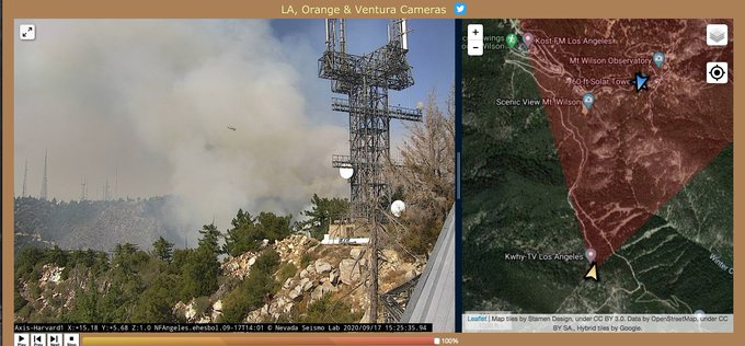
@susankitchens: https://abs.twimg.com/emoji/v2/... draggable="false" alt="1⃣" title="Tastenkappe Ziffer 1" aria-label="Emoji: Tastenkappe Ziffer 1">Photo looking through smoke shows a tower
https://abs.twimg.com/emoji/v2/... draggable="false" alt="2⃣" title="Tastenkappe Ziffer 2" aria-label="Emoji: Tastenkappe Ziffer 2">first map shows Our location at Yellow arrow icon. Red wedge: what we see. Look, there& #39;s a blue arrow icon, for another camera on this site. What is it?
https://abs.twimg.com/emoji/v2/... draggable="false" alt="3⃣" title="Tastenkappe Ziffer 3" aria-label="Emoji: Tastenkappe Ziffer 3">click blue arrow, it& #39;s identified as #MountHarvard.
#bobcatfire
#bobcatfire
 Photo looking through smoke shows a towerhttps://abs.twimg.com/emoji/v2/... draggable="false" alt="2⃣" title="Tastenkappe Ziffer 2" aria-label="Emoji: Tastenkappe Ziffer 2">first map shows Our location at Yellow arrow icon. Red wedge: what we see. Look, there& #39;s a blue arrow icon, for another camera on this site. What is it?https://abs.twimg.com/emoji/v2/... draggable="false" alt="3⃣" title="Tastenkappe Ziffer 3" aria-label="Emoji: Tastenkappe Ziffer 3">click blue arrow, it& #39;s identified as #MountHarvard. #bobcatfire" title=" @susankitchens: https://abs.twimg.com/emoji/v2/... draggable="false" alt="1⃣" title="Tastenkappe Ziffer 1" aria-label="Emoji: Tastenkappe Ziffer 1">Photo looking through smoke shows a towerhttps://abs.twimg.com/emoji/v2/... draggable="false" alt="2⃣" title="Tastenkappe Ziffer 2" aria-label="Emoji: Tastenkappe Ziffer 2">first map shows Our location at Yellow arrow icon. Red wedge: what we see. Look, there& #39;s a blue arrow icon, for another camera on this site. What is it?https://abs.twimg.com/emoji/v2/... draggable="false" alt="3⃣" title="Tastenkappe Ziffer 3" aria-label="Emoji: Tastenkappe Ziffer 3">click blue arrow, it& #39;s identified as #MountHarvard. #bobcatfire">
 Photo looking through smoke shows a towerhttps://abs.twimg.com/emoji/v2/... draggable="false" alt="2⃣" title="Tastenkappe Ziffer 2" aria-label="Emoji: Tastenkappe Ziffer 2">first map shows Our location at Yellow arrow icon. Red wedge: what we see. Look, there& #39;s a blue arrow icon, for another camera on this site. What is it?https://abs.twimg.com/emoji/v2/... draggable="false" alt="3⃣" title="Tastenkappe Ziffer 3" aria-label="Emoji: Tastenkappe Ziffer 3">click blue arrow, it& #39;s identified as #MountHarvard. #bobcatfire" title=" @susankitchens: https://abs.twimg.com/emoji/v2/... draggable="false" alt="1⃣" title="Tastenkappe Ziffer 1" aria-label="Emoji: Tastenkappe Ziffer 1">Photo looking through smoke shows a towerhttps://abs.twimg.com/emoji/v2/... draggable="false" alt="2⃣" title="Tastenkappe Ziffer 2" aria-label="Emoji: Tastenkappe Ziffer 2">first map shows Our location at Yellow arrow icon. Red wedge: what we see. Look, there& #39;s a blue arrow icon, for another camera on this site. What is it?https://abs.twimg.com/emoji/v2/... draggable="false" alt="3⃣" title="Tastenkappe Ziffer 3" aria-label="Emoji: Tastenkappe Ziffer 3">click blue arrow, it& #39;s identified as #MountHarvard. #bobcatfire">
 Photo looking through smoke shows a towerhttps://abs.twimg.com/emoji/v2/... draggable="false" alt="2⃣" title="Tastenkappe Ziffer 2" aria-label="Emoji: Tastenkappe Ziffer 2">first map shows Our location at Yellow arrow icon. Red wedge: what we see. Look, there& #39;s a blue arrow icon, for another camera on this site. What is it?https://abs.twimg.com/emoji/v2/... draggable="false" alt="3⃣" title="Tastenkappe Ziffer 3" aria-label="Emoji: Tastenkappe Ziffer 3">click blue arrow, it& #39;s identified as #MountHarvard. #bobcatfire" title=" @susankitchens: https://abs.twimg.com/emoji/v2/... draggable="false" alt="1⃣" title="Tastenkappe Ziffer 1" aria-label="Emoji: Tastenkappe Ziffer 1">Photo looking through smoke shows a towerhttps://abs.twimg.com/emoji/v2/... draggable="false" alt="2⃣" title="Tastenkappe Ziffer 2" aria-label="Emoji: Tastenkappe Ziffer 2">first map shows Our location at Yellow arrow icon. Red wedge: what we see. Look, there& #39;s a blue arrow icon, for another camera on this site. What is it?https://abs.twimg.com/emoji/v2/... draggable="false" alt="3⃣" title="Tastenkappe Ziffer 3" aria-label="Emoji: Tastenkappe Ziffer 3">click blue arrow, it& #39;s identified as #MountHarvard. #bobcatfire">
Click that small thumbnail image and your view changes to new camera. Now we are at Mt Harvard 2 camera.
(I& #39;m glad I decided to play around with the map layers controls. Now I ~know~ where I am. So to speak.
http://alertwildfire.org/orangecoca/?camera=Axis-Harvard2
https://alertwildfire.org/orangecoc... href="https://twtext.com//hashtag/bobcatfire"> #bobcatfire
(I& #39;m glad I decided to play around with the map layers controls. Now I ~know~ where I am. So to speak.
http://alertwildfire.org/orangecoca/?camera=Axis-Harvard2
 #bobcatfire" title="Click that small thumbnail image and your view changes to new camera. Now we are at Mt Harvard 2 camera.(I& #39;m glad I decided to play around with the map layers controls. Now I ~know~ where I am. So to speak. https://alertwildfire.org/orangecoc... href="https://twtext.com//hashtag/bobcatfire"> #bobcatfire" class="img-responsive" style="max-width:100%;"/>
and we have 2 choppers working this Mt. Wilson Observatory fire. #bobcatfire
I& #39;m going to let this thread go stale for a while because To Do List reasons.
Here& #39;s the
@FlightRadar24
link. Click icons of aircraft you wanna follow to see flight paths.
https://flightradar24.com/multiview/34.2,-118.05/13">https://flightradar24.com/multiview...

I& #39;m going to let this thread go stale for a while because To Do List reasons.
Here& #39;s the
@FlightRadar24
link. Click icons of aircraft you wanna follow to see flight paths.
https://flightradar24.com/multiview/34.2,-118.05/13">https://flightradar24.com/multiview...


