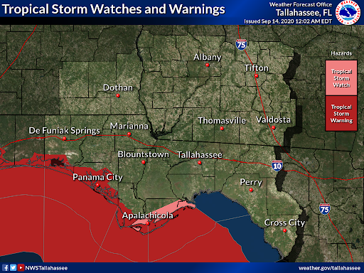
9/13 - 11pm CT. [Thread]. We& #39;re going to detail some of the impacts we& #39;re expecting from #Sally across our forecast area. This data is from the 10pm National Hurricane Advisory. Biggest threat: Flooding rain across much of the area, and dangerous marine conditions along the coast
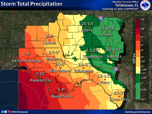
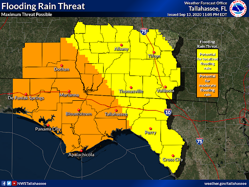
Flooding Threat. A Flash Flood Watch is in effect for many locations across our forecast area with steady ready likely through Tuesday. Additional rainfall possible Wed/Thurs. Forecast amounts through Thursday. #Sally
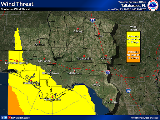
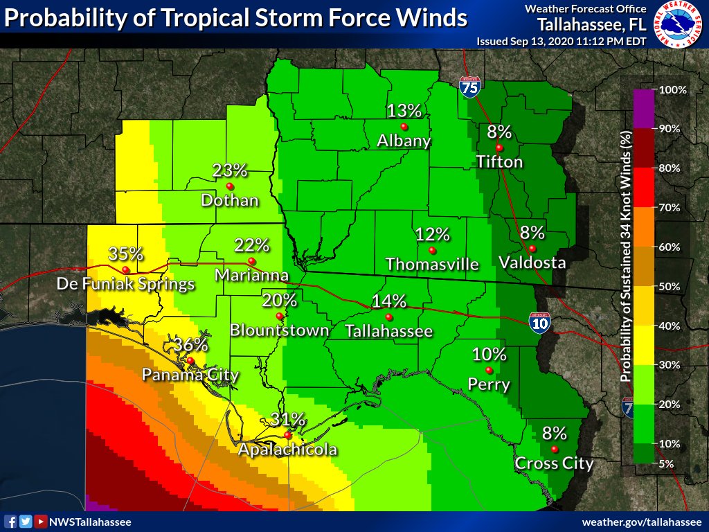
Wind Threat: The greatest threat for tropical storm force winds will be along our coastal regions where Tropical Storm Warnings/Watches are in effect. We can& #39;t rule out isolated tropical storm force gusts in the outer bands from #Sally outside the tropical storm warnings.
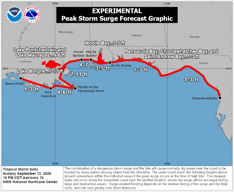
Coastal Flood Threat: There is a threat for some coastal flooding with 1 to 3 ft of surge possible across our coastlines. In addition to the coastal flood threat, elevated surf, dangerous rip currents, and some beach erosion is possible along our coasts due to #Sally
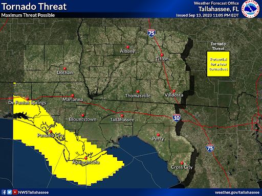
Tornado Threat: As with most tropical systems, there is the potential for tornadoes. We& #39;re looking at the possibility for a few tornadoes, mostly confined near our coastal regions. Make sure you have multiple ways to receive weather warnings during #Sally
This thread highlights impacts from #Sally across our forecast area. To see what& #39;s going on in other locations impacted by #Sally, visit http://weather.gov/socialmedia ">https://weather.gov/socialmed... to find the National Weather Service office you should follow! #TropicalStormSally #FLwx #ALwx #GAwx

 Read on Twitter
![9/13 - 11pm CT. [Thread]. We& #39;re going to detail some of the impacts we& #39;re expecting from #Sally across our forecast area. This data is from the 10pm National Hurricane Advisory. Biggest threat: Flooding rain across much of the area, and dangerous marine conditions along the coast 9/13 - 11pm CT. [Thread]. We& #39;re going to detail some of the impacts we& #39;re expecting from #Sally across our forecast area. This data is from the 10pm National Hurricane Advisory. Biggest threat: Flooding rain across much of the area, and dangerous marine conditions along the coast](https://pbs.twimg.com/media/Eh2Mr_8XYAAZ_T_.png)
![9/13 - 11pm CT. [Thread]. We& #39;re going to detail some of the impacts we& #39;re expecting from #Sally across our forecast area. This data is from the 10pm National Hurricane Advisory. Biggest threat: Flooding rain across much of the area, and dangerous marine conditions along the coast 9/13 - 11pm CT. [Thread]. We& #39;re going to detail some of the impacts we& #39;re expecting from #Sally across our forecast area. This data is from the 10pm National Hurricane Advisory. Biggest threat: Flooding rain across much of the area, and dangerous marine conditions along the coast](https://pbs.twimg.com/media/Eh2PJreWAAAiE7O.png)
