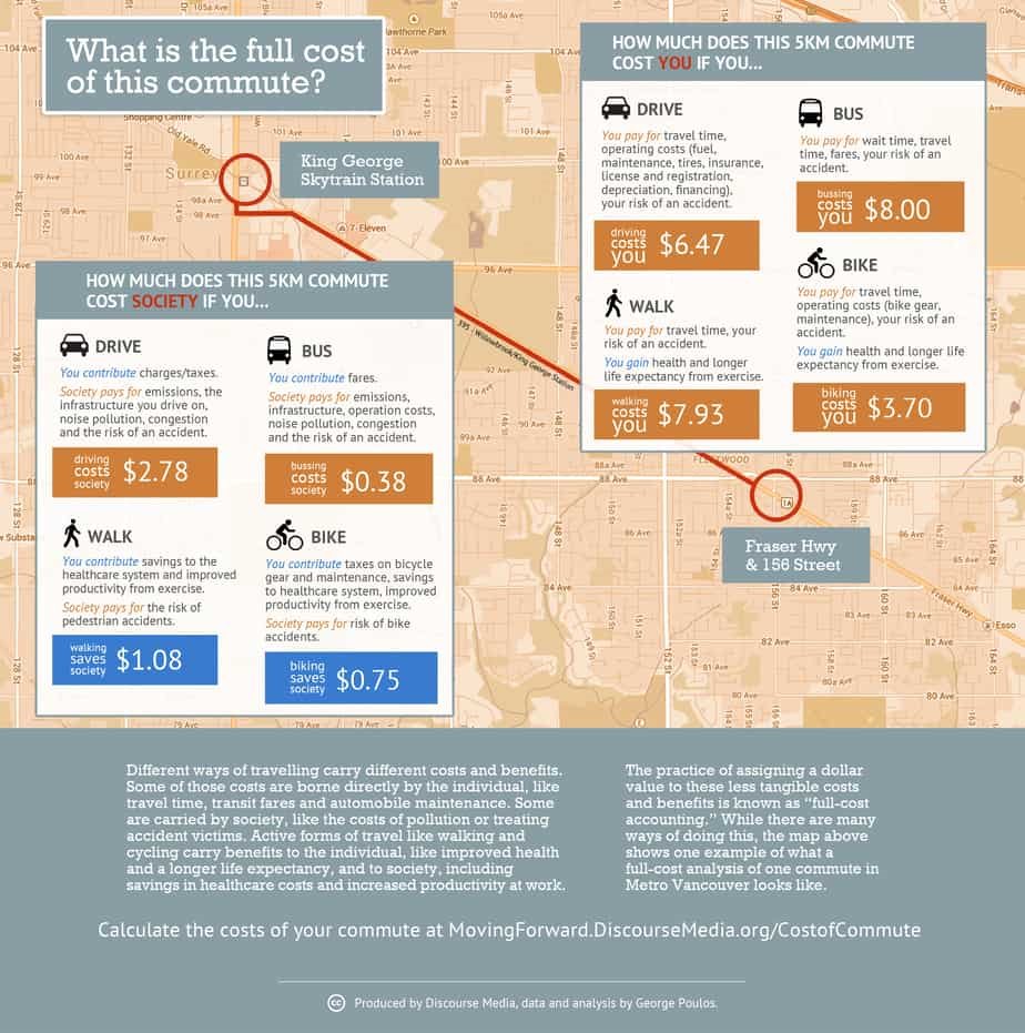
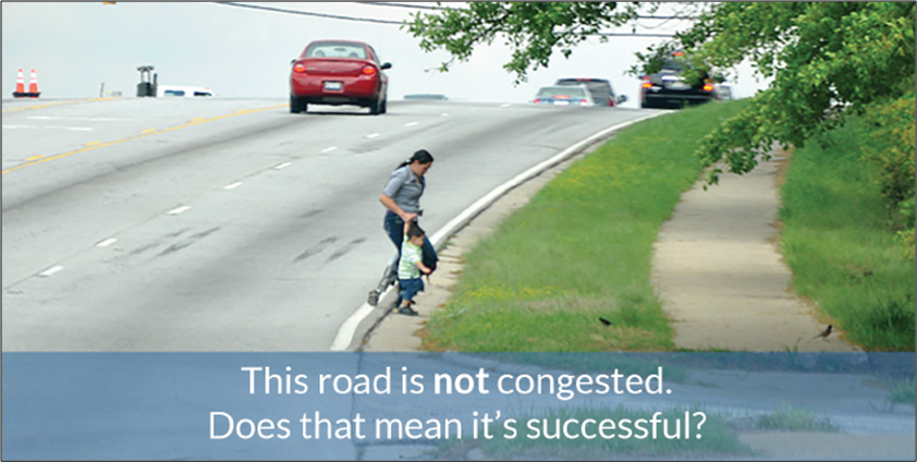
I& #39;ve been asked for some detail about the @CityOfOKC Better Streets, Safer City sales tax, and in particular, the dramatic allocation of funds when sales tax collections exceeded expectations.
Long thread.
Apologies for the length.
(1/?)
Long thread.
Apologies for the length.
(1/?)
Disclaimer:
Tweets and interpretations are my own and may not reflect the point others may have been going for. City staff have processes, rigor, and city branding/messaging to follow as part of their role. So a single point should not necessarily reflect on them.
(2)
Tweets and interpretations are my own and may not reflect the point others may have been going for. City staff have processes, rigor, and city branding/messaging to follow as part of their role. So a single point should not necessarily reflect on them.
(2)
Like all committee meetings, Better Streets, Safer City committee meetings follow the open records act. Anyone can attend, call in, and speak for a couple minutes during a citizen comments section. Most meetings can be found on the @CityOfOKC Channel.
(3) https://www.youtube.com/channel/UCu7sVASWMRZ6V6F7EebBlbA">https://www.youtube.com/channel/U...
(3) https://www.youtube.com/channel/UCu7sVASWMRZ6V6F7EebBlbA">https://www.youtube.com/channel/U...
I voluntarily represent Ward 2 on the Community and Neighborhood Enhancement Advisory Board (CANEAB), informally, the Better Streets, Safer City sales tax advisory committee. My role is to represent perspectives, opinions, and values of the broader public, esp. Ward 2. (4)
I have heard from a number of residents to inform my opinions and actions, but of course, there is a heavy emphasis of my own bike commuting background. By all means, feel free to reach out to me and let me know where your values disagree or align with what I& #39;m stating here. (5)
BSSC is a combination of a couple sales taxes and government obligation bonds that voters approved in 2017. A lot of detail about the process or project status can be accessed here. https://www.okc.gov/residents/better-streets-safer-city-projects
(6)">https://www.okc.gov/residents...
(6)">https://www.okc.gov/residents...
By regulation, bonds are tied to specific projects, so when voters approve a bond for $5M to widen a single mile of SW 15th from Czech Hall to Mustang from 2 lanes to 4 lanes, then once that bond is sold, $5M will go to widening a single mile of road.
(7)
(7)
Even if a traffic study reveals that the road would be safer with 3 lanes while still easily supporting even the most generous projections of traffic volumes, but could instead use better sidewalks and crosswalks by the elementary school, well, you& #39;ll get $5M and 4 lanes.
(8/?)
(8/?)
Those bonds get paid back from the city& #39;s property tax revenue. So it doesn& #39;t matter how much you drive, or if you even own a car. If you pay property tax in OKC, you are paying for OKC roads.
(9/?)
(9/?)
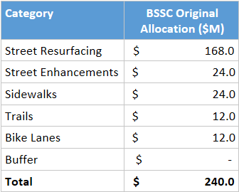
My committee oversees the penny sales tax, which was collected from January 2018 through March 2020. Collections were estimated to be $240M, and voters were presented with an allocation across categories for those funds, along with a prioritization method of projects.
(10)
(10)
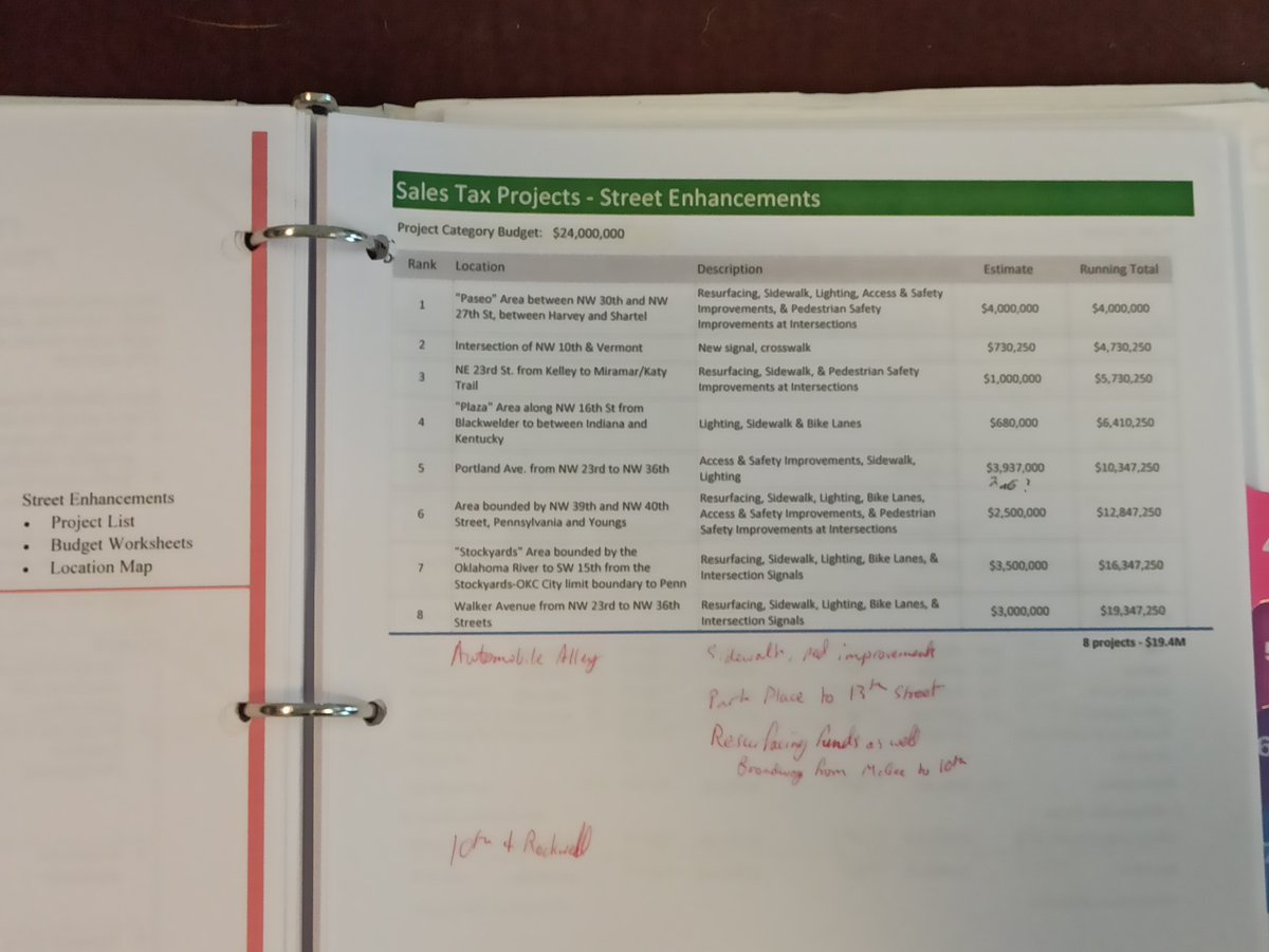
"Street Enhancements" is an umbrella term for improving the pedestrian safety of a particular corridor (think Project 180 downtown). Adding curb bumpouts and crosswalks, street trees, car traffic calming measures, signalized pedestrian crossings, etc.
(11)
(11)
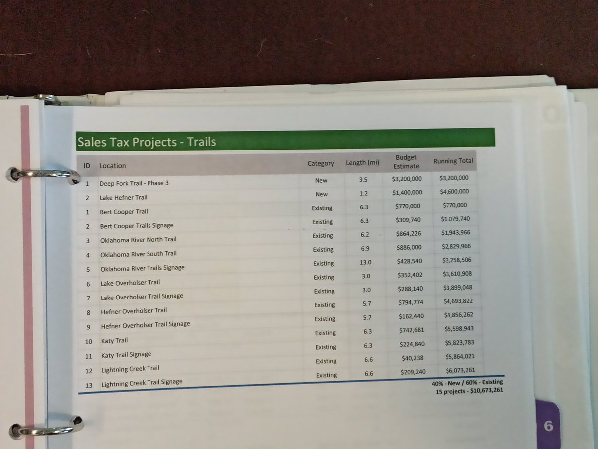
"Trails" refers to paved, off-street multi-use trails. "Bike Lanes" refers to on-street bike infrastructure, which could be cycletrack next to a street, protected bike lane, painted bike lane, or sharrows, depending on various design factors (curb cuts, traffic speeds...)
(12)
(12)
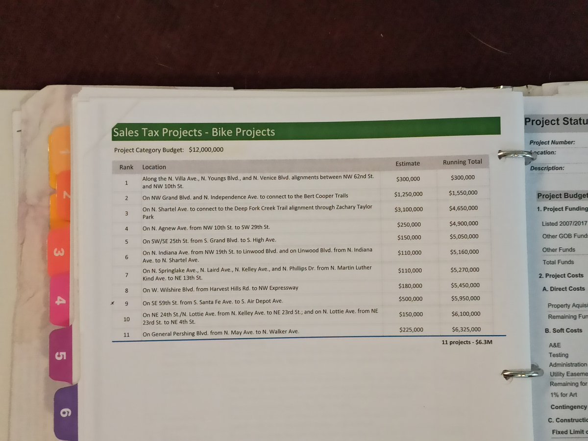
It& #39;s not an exact list, but the prioritization method was discussed, and the @BikeWalkOKC plan was mentioned as a guide, and that a committee would oversee and direct as well. The lists pictured weren& #39;t guaranteed, but the lists did set expectations.
https://www.okc.gov/departments/planning/current-projects/bike-walk-okc
(13)">https://www.okc.gov/departmen...
https://www.okc.gov/departments/planning/current-projects/bike-walk-okc
(13)">https://www.okc.gov/departmen...
This is all funded through sales tax. Again, it& #39;s worth mentioning that regardless of how much you drive or if you even own a car, if you shop in OKC, then you are paying for OKC roads.
(14)
(14)
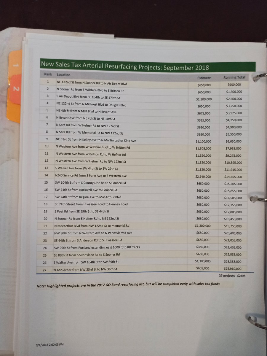
Now, the $168M for resurfacing is the only class of project that is pretty much a "just go do", whereas all the others require concept, design, development, contract, and build. You& #39;ll notice some of the street resurfacing projects are highlighted. Pictured here for clarity.
(15)
(15)
Since there is broad vocal complaining about the quality of our streets, the city was eager to show quick progress on high priority projects. Sales tax revenues come in faster, so $18.9M of sales tax funds actually went to GO Bond street resurfacing projects, and ...
(16)
(16)
...and that $18.9 is not coming back to my committee& #39;s oversight.
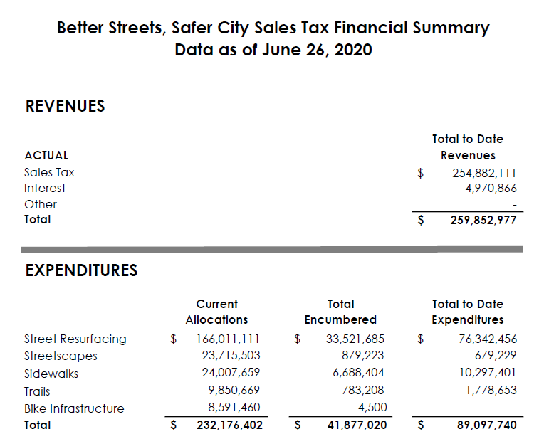
Additionally, because of the "just go do" nature, resurfacing projects dollars got spent the fastest. For instance, here& #39;s allocations and expenditures by category as of June 2020.
(17)
Additionally, because of the "just go do" nature, resurfacing projects dollars got spent the fastest. For instance, here& #39;s allocations and expenditures by category as of June 2020.
(17)
So as of June 2020, projects and initial cost estimates have already been designated for most of the budget. In order to get funding designated for that project, the city brings project descriptions to committee for voting, almost always done in large single-voting blocks.
(18)
(18)
Additional delays to bike and streetscape expenditures relate to setting aside money to be used in federal matching grant programs that the city was applying for, or because there& #39;s overlap in corridors with other projects...
(19)
(19)
...like a bike lane on Independence that crosses NW Expy where the BRT (waiting on federal grand $ to arrive) will be reconfiguring the intersection. So the city wants those other projects to reach their design phase to synergize. (Opinion - that& #39;s all well and pretty good.)
(20)
(20)
Side note: there have now been expenditures on the bike lane for General Pershing Blvd. More to come, including vertical delineators, on this tree-lined connection from @DowntownOKC to the @MAPS3 Will Rogers Trail.
https://twitter.com/rynomars/status/1303310807715983363
(21)">https://twitter.com/rynomars/...
https://twitter.com/rynomars/status/1303310807715983363
(21)">https://twitter.com/rynomars/...
Additionally, the bike lane as currently implemented on South Walker from downtown to SW 36th did not use bike lane funds. Walker got resurfaced through the resurfacing funds. The city saw that it was on the BikeWalkOKC master plan for a protected bike lane, so...
(22)
(22)
...so when repainting the lane lines after resurfacing (which needed to be done anyway) they repainted to account for the future bike lane. Eventually, bike lane funds will be spent to install vertical delineators to make it an actual protected bike lane.
(23)
(23)
So the city looks for synergies where they can. But that& #39;s limited to what is already in the BikeWalkOKC master plan. If a 4-lane arterial that sees 5000 cars per day is going to get resurfaced with BSSC $, the city could repaint it as 3 lanes ...
(24)
(24)
...in line with FHWA guidance to make it not only safer for drivers, but also adds room for parking, street trees, wide sidewalk, or bike lane. But if BikeWalkOKC doesn& #39;t call for anything special on that street, 4 lanes it shall remain.
(25) https://www.youtube.com/watch?time_continue=1&v=naCbw7lwcVw&feature=emb_logo">https://www.youtube.com/watch...
(25) https://www.youtube.com/watch?time_continue=1&v=naCbw7lwcVw&feature=emb_logo">https://www.youtube.com/watch...
On Priorities:
I joined the committee in April 2019 to fill a vacancy. I learned that the prioritization of projects was fixed (as that was what the voters agreed to). For street resurfacing, the prioritization is based on Pavement Condition Index (PCI), ...
(26)
I joined the committee in April 2019 to fill a vacancy. I learned that the prioritization of projects was fixed (as that was what the voters agreed to). For street resurfacing, the prioritization is based on Pavement Condition Index (PCI), ...
(26)
...Maintenance history, crash history, and Average Daily Traffic (Car traffic today, not bus traffic, not future bus routes, not future bike routes and bike lanes, or even current bike and ped traffic. Just cars of today).
(27)
(27)
PCI is partly based on the city& #39;s work order management system, which includes number of reports (and age of reports) from residents. So if you have an issue (a pot hole, a non-ADA compliant sidewalk, faded lane markings, etc.), report it to the @OKCAction Center.
(28)
(28)
Why is it so important to note that the prioritization method is fixed, and that resurfacing funds are already allocated out? That means any projects for bike lanes that need resurfacing need to pay for that resurfacing out of the bike lane budget.
(29)
(29)
For perspective, a bike lane can be on the order of $100K per mile, while resurfacing can be 10x that.
The list of bike lane projects initially proposed for the $8.6M shown above don& #39;t account for the amount of resurfacing work that needs to be done.
(30)
The list of bike lane projects initially proposed for the $8.6M shown above don& #39;t account for the amount of resurfacing work that needs to be done.
(30)
Everyone on committee and staff seem to agree that paint over potholes is a waste of money for everyone. So the roads (like Villa, like Independence, like Main Street, like South 25th) need to be resurfaced.
(31)
(31)
But that means the $12M original budget doesn& #39;t come close to meeting even the $6.3M of projects pictured in tweet 13 that voters were expecting.
(32)
(32)
Committee members (more than just me) have voiced the need for resurfacing on many such bike projects for about a year, and that using street resurfacing funds would make sense. It meets the intent of the project allocations and benefits people on bikes as well as in cars.
(33)
(33)
But alas, apparently the prioritization method was not allowed to budge. (In theory, city staff could have taken a resolution approved by the committee to city council in order to re-prioritize, but they never went down that route.
(34)
(34)
Apparently there& #39;s enough disdain for the quality of our roads that some see any money for bike lanes as waste or theft from resurfacing. But safe bike infra gets people to use vehicles that are 2 tons lighter, which saves so much on wear and tear.) https://twitter.com/carlitecarfangs/status/1124300667487752193
(35)">https://twitter.com/carliteca...
(35)">https://twitter.com/carliteca...
I& #39;ll take you back to the February meeting where the final $24M of road resurfacing was proposed by the city. In reality, there& #39;s no need to rush in allocating projects, other than to lock it in for streets that don& #39;t have BikeWalkOKC planned routes.
(36)
(36)
(We& #39;ve only spent 45% of the street resurfacing budget in 2 years, so we really had at least a year more to understand the transportation and resurfacing need for those last $24M.)
(37)
(37)
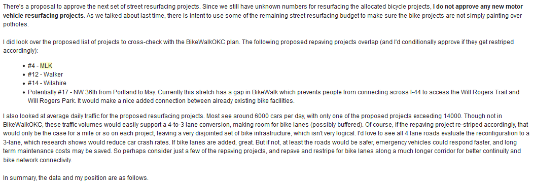
So here was my opinion on the final $24M. Note the amount of money spent on low-traffic, overbuilt roads. There are bike lane projects in BSSC that have higher ADT, and cracks that aren& #39;t just uncomfortable for drivers, but are serious issues for narrow bike tires.
(38)
(38)
Apparently those bike lane projects didn& #39;t make the resurfacing list based on the original prioritization method. It& #39;s yet to be seen if the projects in @BikeWalkOKC1 will get a new lane configuration.
(39)
(39)
FYI the FHWA guidance is that 3 lanes supports an ADT of 14000 with no impact to traffic, and reduces crashes up to 47%. FHWA has been recommending it since 2016.
https://iowadot.gov/traffic/4-to-3-lane-conversion/3-lane-roads
(40)">https://iowadot.gov/traffic/4...
https://iowadot.gov/traffic/4-to-3-lane-conversion/3-lane-roads
(40)">https://iowadot.gov/traffic/4...
The committee ultimately passed this, allocating money to the above projects. There& #39;s no obligation of the city to reconfigure lanes on overbuilt roads though, or enhance the safety of the streetcar tracks. But they& #39;ve heard me often. https://www.strail.de/level-crossing-systems/?lang=en
(41)">https://www.strail.de/level-cro...
(41)">https://www.strail.de/level-cro...
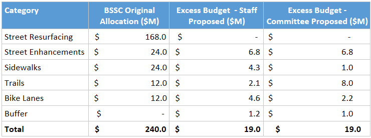
Onto current events. #BetterStreetsSaferCity sales tax collections went from January 2018 through March 2020. It was projected to raise $240M. In actuality, it raised $259M. So the discussion of the past 2 months has been how to allocate that extra $19M.
(42)
(42)
July 6 CANEAB committee meeting is the first time excess funds is discussed (as the tax revenue through March is now finalized. Side note: there& #39;s a good discussion about the design of the Portland Street Enhancement project from 23rd to 36th. https://www.youtube.com/watch?v=AwdumbzsB9E
(43)">https://www.youtube.com/watch...
(43)">https://www.youtube.com/watch...
I had a lot to say in frustration about the city& #39;s scoping of the project, which ultimately will pay to widen the street in order to add a pedestrian island in the middle to make crossing safer…
(44)
(44)
The city was not willing to consider reconfiguring the underutilized stretch of road per FHWA guidance to narrow the overall crossing distance. There were statements like it& #39;s not in scope, despite scope explicitly being pedestrian safety.
(45)
(45)
Again, this falls into the category of not actually pedestrian infrastructure. "Pedestrian islands" just ensure car traffic is not interrupted or inconvenienced in any way.
More on that in this thread: https://twitter.com/carlitecarfangs/status/1303361663958212610
(46)">https://twitter.com/carliteca...
More on that in this thread: https://twitter.com/carlitecarfangs/status/1303361663958212610
(46)">https://twitter.com/carliteca...
As for the excess funds: the city proposed a great spread. I& #39;m usually critical of most things at these meetings (I live and breathe poor bike infra every day), but I loved this allocation. It took into account a lot of themes the committee had been pushing for a while.
(47)
(47)
Understanding the need to resurface areas of street enhancements and bike lanes, the city set about $2.6M to Street Enhancements, and $2.6M to Bike Lanes. The idea with that $5.2M was to help already planned projects reach their potential, in line with voters& #39; expectations.
(48)
(48)
The city reserved $1.2M for a buffer for now. Then, the remaining $12.6M Was split among the 4 non-resurfacing categories according to the initial allocation proportions. So 33% Street enhancements, 33% to Sidewalks, 16% Bike lanes and 16% Trails.
(49)
(49)
Committee Chair McKnight moved to defer to give the committee time to think about it. (He also oversees the MAPS3 Trails Citizens Advisory Subcommittee.)
(50)
(50)
Are you still following along? Awesome. It gets a little heated as the bike community fights over scraps. Lots of arguing on FB as well during this time. Thank you for being interested in municipal dramas. I personally think they are more entertaining than Prime-Time TV.
(51)
(51)
Aug 3 CANEAB committee meeting:
McKnight introduced his proposed funding.
https://www.youtube.com/watch?v=5vzt3QB4T8U&list=PLwFAYTiZB_PINF4r200VOpseU9ZYM2VWx&index=4&t=0s
There">https://www.youtube.com/watch... was a lot of discussion, including the fact that the $53.4M in trails from the 2007 Bond, the 2017 Bond, and MAPS 3 shows that "if you build it, they will come".
(52)
You may recall that powerful messaging used by @dodsonster last summer during the #MAPS4 hearings, describing how our MAPS sales taxes have proven time and again "if you build it, they will come."
(53)">https://youtu.be/8jIVYx7Qv...
(53)">https://youtu.be/8jIVYx7Qv...
His is a great 3 minutes, but I get giddy chills just rewatching the bike projects portion. An hour of community vocalizing taking time out of their workday in strong support of safe streets and protected bike lanes (including a some bike tourists from NYC).
(54)
(54)
Back at BSSC, we are seeing more people try biking for commutes and other errands. And we& #39;re hearing how so many people are trying out biking for the first time, but are frustrated they have to pack a bike in their car to drive a mile to safely use the trails we& #39;ve built.
(55)
(55)
This has come up time and again, and a frequent question that comes up on Facebook cycling groups is "where do you park at [INSERT NAME] Trail?"
https://twitter.com/carlitecarfangs/status/1297608294383652864
(56)">https://twitter.com/carliteca...
https://twitter.com/carlitecarfangs/status/1297608294383652864
(56)">https://twitter.com/carliteca...
FYI, OKC sports 110 miles of paved trails, compared to Chicago that has 25 miles, for example. On a per-capita basis, that works out to OKC having about 15 times as much trail per person to enjoy. On a square mile basis, OKC has about 1.6 times as much trail as Chicago.
(57)
(57)
But the Deep Fork Trail is expected to be severely over budget and needing more funds. The Katy Trail needs enhancements for safety. and signage/wayfinding and amenities on our trails are needed as well. And the West River Trail continues to plague MAPS 3.
(58)
(58)
Committee Member Groves of Ward 3 noted Wards 3 and 5 don& #39;t have any trails.
Bike tourism also favors long connected loops. If you have 20 miles of trails, on may check it out when passing through. 500 miles of trails? Tourists plan a 2 week trip and fly across continents.
(59)
Bike tourism also favors long connected loops. If you have 20 miles of trails, on may check it out when passing through. 500 miles of trails? Tourists plan a 2 week trip and fly across continents.
(59)
This thread from Brent Hugh at the 2019 Oklahoma Bike Summit goes in depth, referencing the Missouri Trail System and the NW Arkansas Trail system as examples - with economic data strong slogans to back it up. https://twitter.com/carlitecarfangs/status/1188058726491676672
(60)">https://twitter.com/carliteca...
(60)">https://twitter.com/carliteca...
Also worth noting that drivers texting can still run red lights and veer into bike lanes, or think bike lanes are parking. Trails don& #39;t typically have the same challenges. Here& #39;s a truck in the new Walker Bike Lane. https://twitter.com/carlitecarfangs/status/1289289949347344384
(61)">https://twitter.com/carliteca...
(61)">https://twitter.com/carliteca...
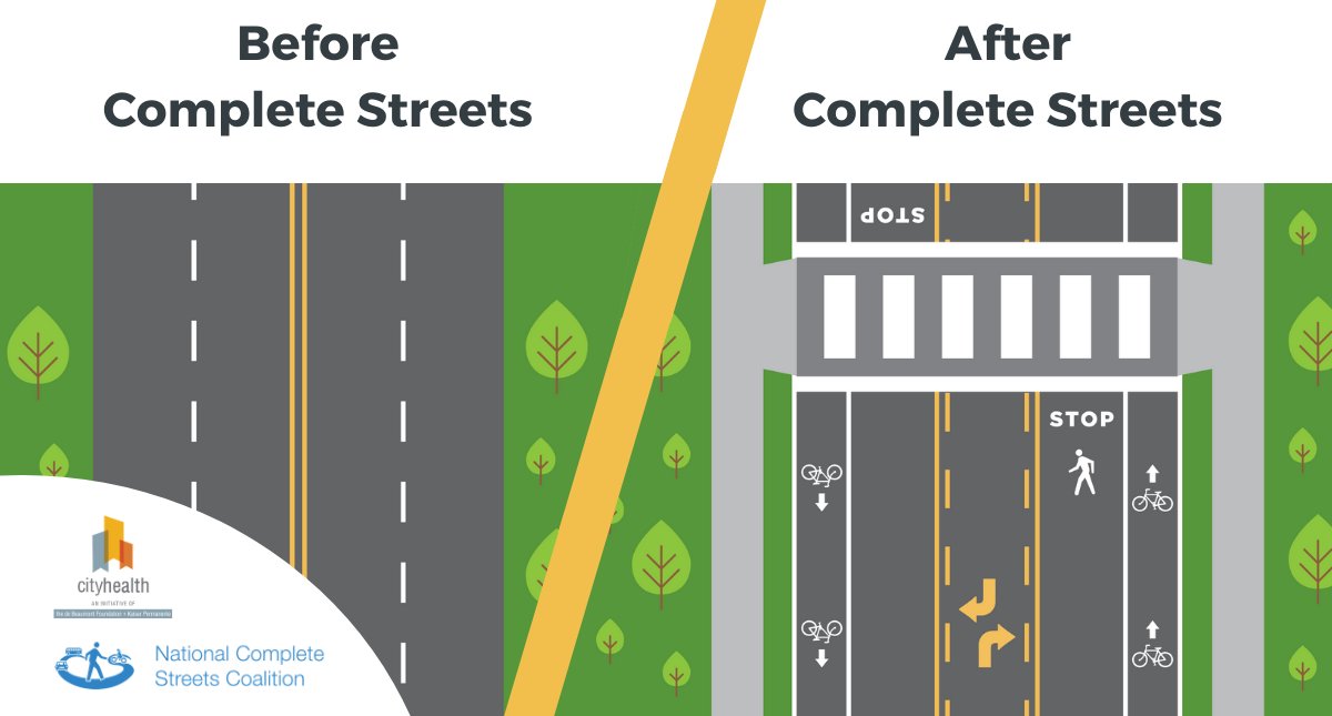
That being said, complete streets - roads that are adequately designed for safe usage for people on bikes or foot or wheelchair, also have fewer car-to-car crashes, and fewer car-to-pedestrian crashes.
(68)
(68)
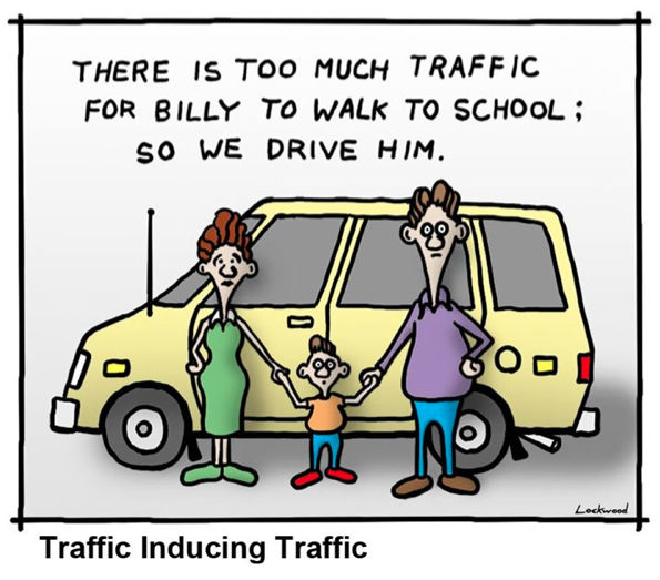
It& #39;s a broader impact than just bicyclists. Safe streets bring out bike commuters, which reduces the number of cars. So streets are EVEN safer, and parents are more comfortable walking their kids to school. It& #39;s a great positive reinforcement cycle to invest in.
(69)
(69)
Maybe we& #39;ll get to the point where Copenhagen is - where any streets where motor vehicles and bicycles share space, streets are designed to be 15mph. Then any additional bike infrastructure is off-street trail, and we& #39;d have enough trail to criss-cross the city and ...
(70)
(70)
...and get to all the schools and restaurants we want to by trail. $16M over 10 years (proposed BSSC excess funds and MAPS4 for trails) won& #39;t get us that far though.
Perhaps revised city policy where any underutilized street gets a makeover when resurfaced, ...
(71)
Perhaps revised city policy where any underutilized street gets a makeover when resurfaced, ...
(71)
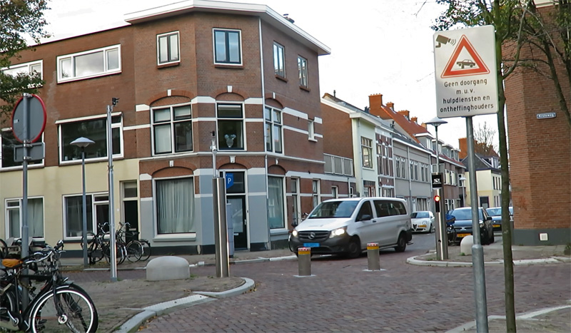
...or that neighborhood streets get bollards so that there is no desire for cars to cut through neighborhoods, but bikes could for safety and convenience, and residents can still drive in.
(72)
(72)
That would help make this argument of bike infrastructure money even less critical (over a pretty small amount of money in the grand scheme of municipal budgets, at that). For certain reasons though, that& #39;s not seeming likely any time soon.
(73)
(73)
After much discussion, committee passed McKnight& #39;s allocation 7 to 2, with dissents from myself and Dahlgren of Ward 6 (who preferred the city& #39;s allocation).
Note, no one on the committee or staff argued for more pure resurfacing funds. Progress? @okprogressnow
(74)
Note, no one on the committee or staff argued for more pure resurfacing funds. Progress? @okprogressnow
(74)
Aug 17 Council Meeting ultimately deferred for 2 more weeks. But some high points were:
Councilperson Stonecipher wanting to honor our committee processes, and council shouldn& #39;t go against an overwhelming committee recommendation.
(75)
Councilperson Stonecipher wanting to honor our committee processes, and council shouldn& #39;t go against an overwhelming committee recommendation.
(75)
Councilpersons Cooper and Hamon wanted to even the amount of funding that active infrastructure has been seeing (e.g. from 2007 bond on through MAPS 4, roughly $73M for trails, and $32M for bike lanes, plus the BSSC extra allocation).
(76)
(76)
Councilperson Cooper reiterated the need for basic connectivity from neighborhood to bus stop through safe and well-maintained sidewalks and bike infrastructure, and the committee allocation takes away from that potential.
(77)
(77)
Councilperson Nice wants to see Ward 7 have just as high quality trails as the rest of the city, as they rightfully deserve nothing less. In fact, the Katy Trail was a highlight by bike touring visitors from NYC during the MAPS 4 hearings last summer.
(78)
(78)
Councilperson Greenwell wanted each ward to take a piece of the $19M pie and do with it what they will (counter to the city, the committee, and the process, while also devoid of systemic connectivity).
(79)
(79)
A few members mentioned their continued hearings from constituents for more street resurfacing. (Of course, the 2017 Bond includes $294M for that, plus another $77M just for road widening).
(80)
(80)
Sept 1 meeting:
Mostly a repeat of opinions from before, with a few new citizens calling in requesting to go with the city staff& #39;s original proposal.
Council ultimately voted for the committee& #39;s budget.
(81)
Mostly a repeat of opinions from before, with a few new citizens calling in requesting to go with the city staff& #39;s original proposal.
Council ultimately voted for the committee& #39;s budget.
(81)
Ending:
I& #39;ll be looking to use this extra trails money to support enhanced community connections, and ensure we have a fully-connected trail system to boost tourism. Signage, amenities, and maintenance budget to make our trails remain great...
(82)
I& #39;ll be looking to use this extra trails money to support enhanced community connections, and ensure we have a fully-connected trail system to boost tourism. Signage, amenities, and maintenance budget to make our trails remain great...
(82)
Ideally, perhaps able to implement a few greenways to help families bike to school.
I& #39;ll also be working to encourage the city to update policy along the lines of tweets 68 and 72, with a more fiscally prudent and efficient utilization of space that yields better safety.
(83)
I& #39;ll also be working to encourage the city to update policy along the lines of tweets 68 and 72, with a more fiscally prudent and efficient utilization of space that yields better safety.
(83)
I& #39;ll end with this rant because it is so frustrating for safe infrastructure for PEOPLE to fight over scraps, when car-based infrastructure is so willingly spent.
(84)
(84)
The 2007 bond and 2017 bond includes $149M just for road widening. That& #39;s $40M more than trails and bike lanes from 2007 to 2030 combined.
This leads to a bigger maintenance burden for the city.
(85)
This leads to a bigger maintenance burden for the city.
(85)
If you want the city to be better about the quality of our streets, we need 2 things:
- Stop widening roads!
- Focus on making it convenient and safe for people to willingly choose a mode of travel that& #39;s 2 tons lighter.
(86)
- Stop widening roads!
- Focus on making it convenient and safe for people to willingly choose a mode of travel that& #39;s 2 tons lighter.
(86)
The city& #39;s guidelines for widening are also well below FHWA thresholds for traffic volume, and "traffic projections" throughout the city don& #39;t pan out.
(87)
(87)
Basically, the city& #39;s policy is to widen roads to support the projected traffic 20 years from now assuming 2% ANNUAL growth rate. How accurate is that model?
In almost all places throughout the city, it& #39;s close to 0% over the last 20 years.
(88)
In almost all places throughout the city, it& #39;s close to 0% over the last 20 years.
(88)
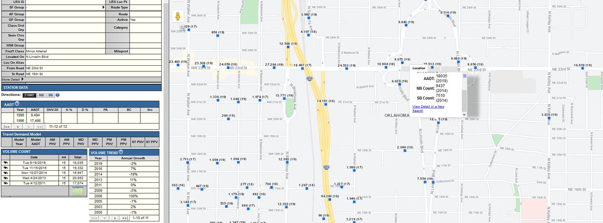
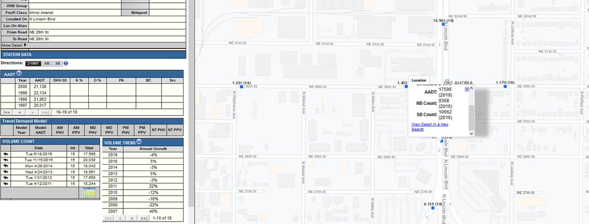
Some samples from @ACOGOK. Here& #39;s Lincoln Blvd both south and north of the State Capitol Building. South: it& #39;s flat. North of the Capitol, it& #39;s actually DOWN 13% over 20 years.
(89)
(89)
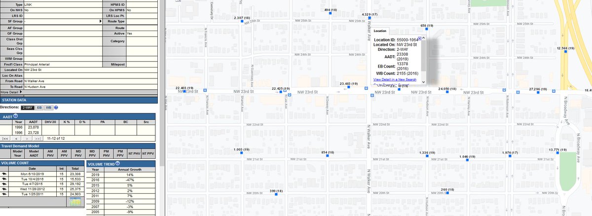
A little west, at the hot spot of @Uptown23rd, traffic counts have been relatively flat over the past 20 years.
Near Quail Springs Mall: jump from 1999 to 2003 and again in 2006, but practically flat since then.
(90)
Near Quail Springs Mall: jump from 1999 to 2003 and again in 2006, but practically flat since then.
(90)
West OKC near the Kilpatrick Turnpike and a proposed $3M widening of a 2-lane to a 4-lane. The turnpike& #39;s existence is used as a reason to expect growth. But here we see volume has declined over the past 20 years, and 60% off its peak of 2006.
(91)
(91)
SE OKC: Anderson is a 4-lane road, 74th is a 2 lane road. The intersection was recently widened to 5 lanes in each direction. Less than 8000 ADT on Anderson, less than 1000 on 74th. The trend is pretty flat over 7 years, even despite a new (2015) subdivision to the east.
(92)
(92)
In most places throughout the city, it& #39;s close to 0% over the last 20 years (with some local and temporary effects based on when new developments pop up, or a new road opens (OKC Blvd goes from 0 in August 2019 to 7000 in Sept 2019, with 11 crashes at a single intersection).
(94)
(94)
ACOG has the data. By all means, please browse the history of our traffic counts and PLEASE find examples that justify the city& #39;s assumption of 2% annual growth rate. If you succeed, it would help rectify the city& #39;s otherwise bonkers policy. http://www.acogok.org/transportation-planning/congestion-management/traffic-counts/
(95)">https://www.acogok.org/transport...
(95)">https://www.acogok.org/transport...
You would help my sanity, but I still disagree that we should plan and budget based on that idea alone. (Systemic impacts are significant, e.g. opening OKC Blvd didn& #39;t create 7000 new drivers. They likely came from alternate routes).
(96)
(96)
But ultimately, it& #39;s wasteful spending on infrastructure that increases maintenance costs, induces more driving, induces higher speeds, and leads to more car-to-car crashes (which also leads to more police work).
(97)
(97)
I really want my city to be able to afford basic services rather than drown in an endless cycle of street maintenance, and I just want my community, my daughter, my coworkers to be safe.
(98)
(98)
Please let me know:
- how you feel,
- where/why you agree,
- where/why you disagree,
- what I& #39;m missing,
- and how we might find an end to the madness, the fiscal irresponsibility, the disregard for much safer best practices.
(99)
- how you feel,
- where/why you agree,
- where/why you disagree,
- what I& #39;m missing,
- and how we might find an end to the madness, the fiscal irresponsibility, the disregard for much safer best practices.
(99)
I feel obligated to say I kept my story it under 100 tweets. (kinda)
Also Obligatory: Thanks for coming to my TED talk.
#BetterStreetsSaferCity - Better and Safer for whom?
#Bikes4FiscalPolicy
#Bikes4EconomicPolicy
#Bikes4Community
(100).
Also Obligatory: Thanks for coming to my TED talk.
#BetterStreetsSaferCity - Better and Safer for whom?
#Bikes4FiscalPolicy
#Bikes4EconomicPolicy
#Bikes4Community
(100).

 Read on Twitter