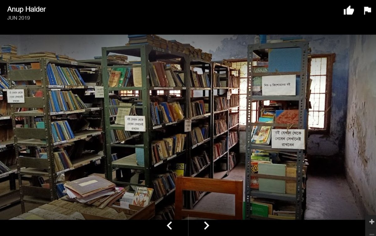
On your left: image from Google Photos courtesy Arup Halder, a view of the dinghy lending room of the Kalyani Public Library from 2019. The last shelf is for young readers. Yes, just the one.
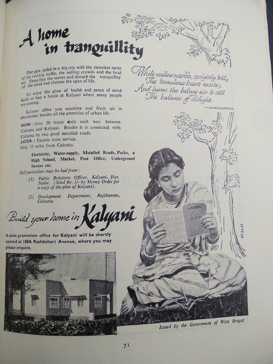
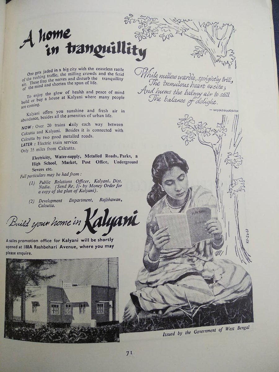
On your right: a govt advt. for our town, prob. from the 60s.
On your right: a govt advt. for our town, prob. from the 60s.
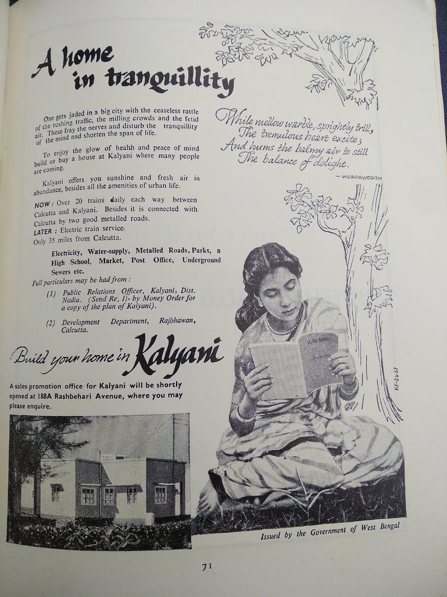
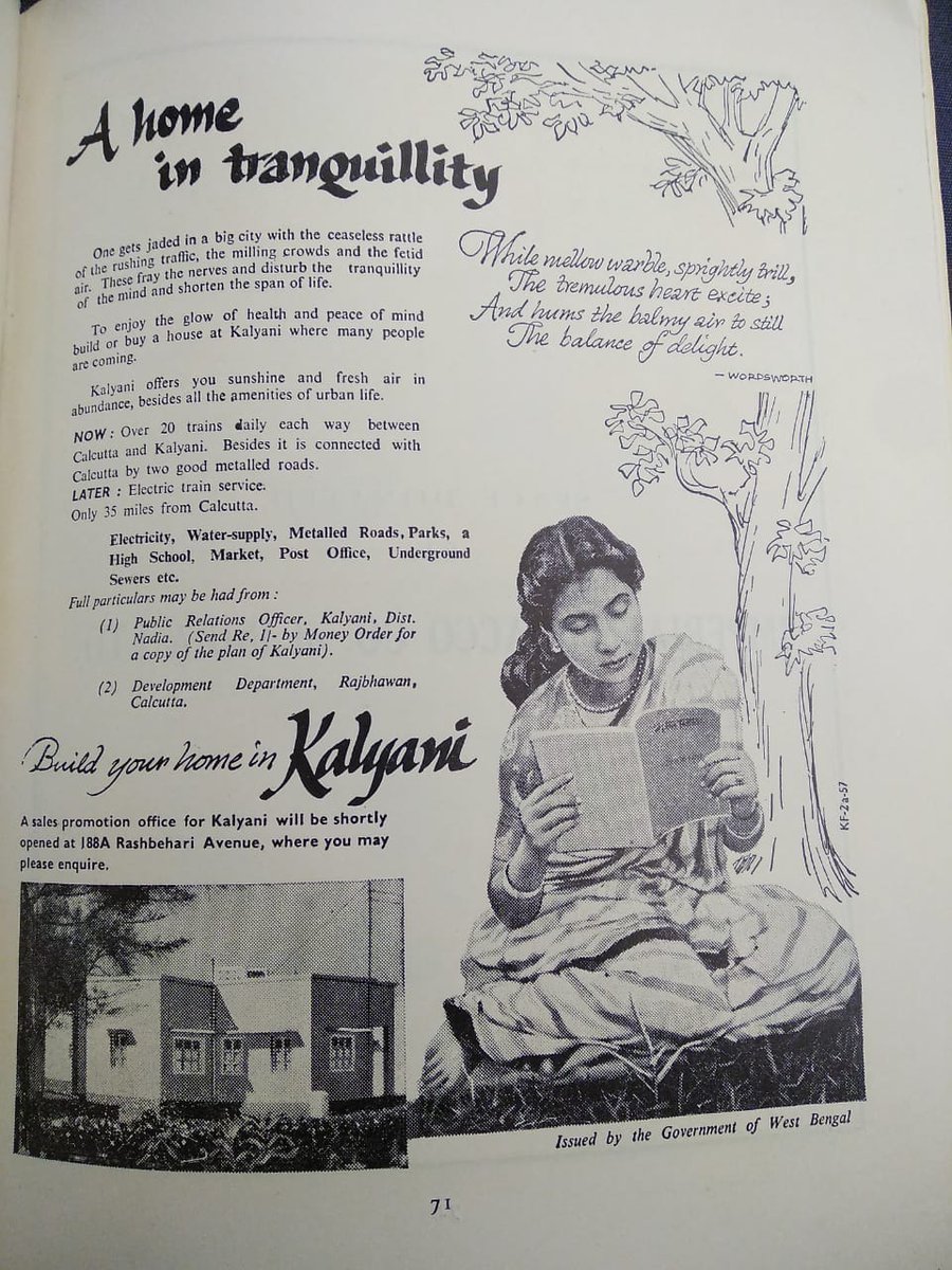
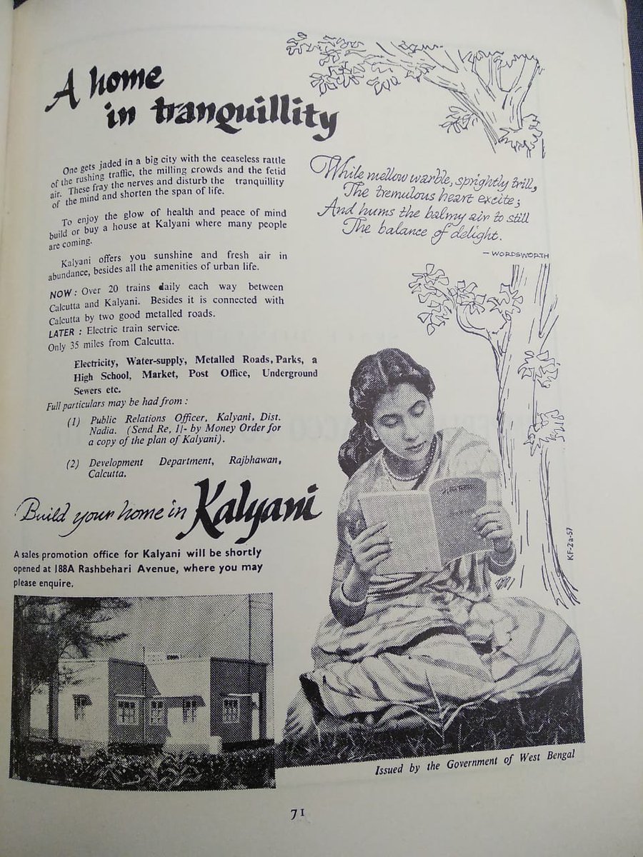
This image is courtesy Mousumi Mandal, who very generously shared it from her archival work. Both of us forgot to note complete bibliographical details, which is why it will never be on anything academic. But look at this advertisement. Look at it!
The promises of sunshine, fresh air, and amenities! But the dominant aspect of the image is the woman in faintly Shantiniketani style sari, reading something by Rabindranath Tagore. The Wordsworth quotation is meant to complement the image of the woman reading, of course.
I screeched when I saw this, because after 5 years of obsessing over women& #39;s reading practices, I did not expect one to land up in a govt advt for my hometown. This image is a sarkari babu thinking, & #39;How can we best sell the CM& #39;s vanity project to bhadralok?& #39;, and going wild.
Who would have thought that after 150 yrs of waffling over women reading, the govt of WB would actually use & #39;women can read peacefully here& #39; as a bhadralok selling point of a place? (And then keep one shelf in the library for kids. Not bitter at all.)
In roughly a century, the woman reading silently and thinking god knows what, has gone from an image of horror to an image sold to upwardly mobile uc homeowners. She& #39;s at leisure, reading Tagore - the picture of respectability. No one& #39;s asking if she& #39;s neglecting domestic work.
She& #39;s also very clearly - and I can& #39;t stress this enough - is a uc bhadramahila, as are the potential homeowners who will be lured by this image to move from Calcutta to the suburbs. (As it turned, the only people it really worked on at the time were uc refugees.)
There& #39;s an underlying logic that accompanies these planned new towns, be it Salt Lake-Rajarhat, the mighty Noida and Gurgaon, or our humble Kalyani: it& #39;s the logic of a blank slate, dreamed up by enterprising men, a fresh start. (You can see why it appealed to refugees.)
Except: the land wasn& #39;t a blank slate, was it?
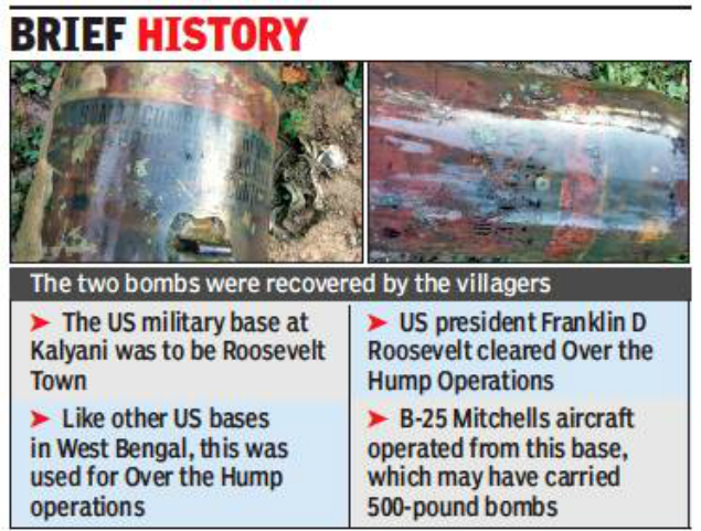
In 2018, villagers discovered two WW II-era bombs in Hanshkhali (a neighbouring village in the Kalyani sub-division). Experts felt they were a part of the Roosevelt Nagar arsenal.
In 2018, villagers discovered two WW II-era bombs in Hanshkhali (a neighbouring village in the Kalyani sub-division). Experts felt they were a part of the Roosevelt Nagar arsenal.
In 1943, Roosevelt&Churchill discussed a military base in this area. It wasn& #39;t a major operational base, but these bases in WB/Assam were necessary for supporting Chiang-Kai-Shek& #39;s war efforts against the Japanese assault. (Remember Calcutta was bombed.) https://www.thebetterindia.com/138214/world-war-2-bombs-west-bengal/">https://www.thebetterindia.com/138214/wo...
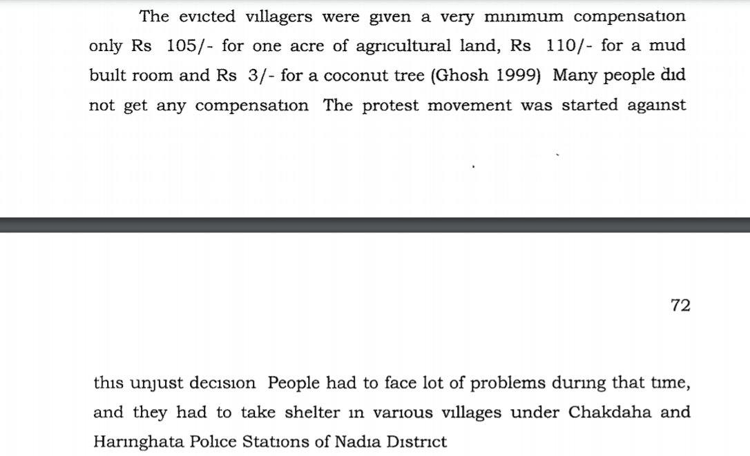
So the very important task of the war effort, decided upon by two very important men in faraway countries, evicted 45 villages in the area with almost no compensation. Santi Lata Biswas has documented this in her unpublished thesis (on Shodhganga).
Here& #39;s what Biswas writes: Rs 105/acre by the mighty British Empire + mighty Americans. Many didn& #39;t receive even that.
Remember the year? It& #39;s 1943. That& #39;s right, the Bengal Famine.
Remember the year? It& #39;s 1943. That& #39;s right, the Bengal Famine.
Remember that Churchill& #39;s scorched earth policy to deny supplies to the Japanese had two aspects: rice denial, where soldiers confiscated/destroyed surplus rice; boat denial - confiscated transport, esp boats (in riverine Bengal!). (Ref. Madhusree Mukerjee)
From famine reports, we know that the Nadia district was very badly hit, esp. the Kusthia subdivision (now in Bangladesh). So in 1943, in the middle of a mounting famine, Churchill and Roosevelt evicted 45 villages with pennies because YOLO.
(The narrative of the famine is so Calcutta-centric that we forget where all the hungry people came from. They came from the districts, courtesy dispossession of various sorts. Calcutta was not lacking in five course meals in restaurants. This is a part of Kalyani& #39;s history.)
Post-independence, the govt of WB took over Roosevelt Nagar, acquired 14 more villages, and planned a new town. No returning the land to the villagers originally displaced (cultivation of course would have been difficult initially, but this is Nadia, as fertile as it gets).
The 14 villages had names like: Muratipur, Jadubati, Majherchar, Charkanchrapara, Ghospara, South Bhabampur, Gopalpur, Chandmari, etc. Some names still live on in the lexicon of the town. They& #39;re the fringes of the new town, occupied by another set of dispossessed people.
Yes, the year is 1947, and we& #39;re talking about the Partition of Bengal. In the dominant narrative of Partition of Bengal, every refugee (like my family) left East Pakistan for Calcutta. Yes, every single one of them. There& #39;s no other place in West Bengal.
Except, that& #39;s not true either. Nadia is a border district. It was sliced in half by the Partition, and had an overwhelming two way migrant movement. Nadia, pre-independence was a Muslim majority district. Post-independence, it is a Hindu majority district. (See Subhasri Ghosh)
(Aside: Nadia also saw some Muslims returning, and there& #39;s considerable tension between the Namasudra refugees, the Muslims who returned and the Muslims who never left.)
(Also aside but whatever, I& #39;m rambling: in a cartographic error, initially all parts of Nadia except Nabadwip subdivision was included in East Pakistan. Parts of Nadia remember this by celebrating independence on Aug 17/18.) https://timesofindia.indiatimes.com/city/kolkata/Nadia-keeps-a-date-with-history/articleshow/9654550.cms">https://timesofindia.indiatimes.com/city/kolk...
This heavy movement of refugees in a district sliced in half meant that you had refugee camps in Dhubulia (near Krishnanagar), Cooper& #39;s Camp and Rupasree Pally (Ranaghat), and of course, Kalyani& #39;s very own Chandmari Camp.
Kalyani may now have 4 railway stations, but earlier it was just the one: Chandmari Halt. Manohar Roy (may or may not have been an associate of Jogen Mandal) organized the Purba Banga Bastuhara Samiti in Chandmari Camp for the Namasudra refugees there.
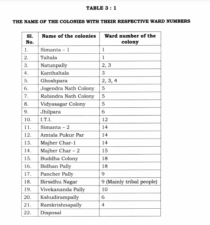
In the dominant narrative of the Partition, refugee colonies existed in and around Calcutta (because there& #39;s no place outside Calcutta). However, the Namasudra refugees of Nadia built their own colonies - including those on the fringes of Kalyani town.
I turn to Santi Lata Biswas again, for her excellent documentation. ( https://shodhganga.inflibnet.ac.in/handle/10603/209937)
Yes,">https://shodhganga.inflibnet.ac.in/handle/10... Jogendra Nath. Who would name their refugee colony after Jogendra Nath Mandal?
Yes,">https://shodhganga.inflibnet.ac.in/handle/10... Jogendra Nath. Who would name their refugee colony after Jogendra Nath Mandal?
Every colony had its complex history. Camp refugees, non-camp refugees. The struggle for patta, multiple eviction attempts, further influx of refugees in 1970-71. I& #39;ll simply leave you with Santi Lata Biswas& #39; statement here:
And that really brings us back to this. The tantalizing image of the bhadramahila as a reader, this time as a picture of upward mobility. The narrative of the planned town erases and sanitizes this complex history of the region, marked by dispossession and migration.
The narrative of the planned town, epitomized by this image, hides in plain sight a simple fact: planned segregation.
I say in hidden in plain sight, because there& #39;s another deep history of this land, dating back to the 17th century. Ghoshpara - the acquired village, the refugee colony, the railway station - is home to the kartabhaja sect, disciples of Aulchand.
Dol Purnima every year sees the Sati Ma& #39;r Mela, with worshippers pouring in (including from Bangladesh). It& #39;s not a coincidence that a large section of the devotees are Namasudra, Kaibarta, Mahisya, and so on. https://www.thewall.in/news-west-bengal-sati-mar-mela-holi-celebrated-in-nadia-kalyani/">https://www.thewall.in/news-west...
No matter how much you sanitize and erase the complex history of the land, and give it a coat of respectability, the Sati Ma& #39;r Mela - for those seven days at least - allows no such thing. The mela belongs to Ghoshpara, to Muratipur, to Chandmari and Jogendra Nath Colony.
With rising anti-refugee sentiments, and NRC-related tension, I worry what the future holds for a town like ours, and the areas surrounding it. But meanwhile, I can only ramble about it, hoping to maybe de-center how we look at the history of Partition and migration in Bengal.
PS: If you& #39;ve read this much hyajano, you might as well read this. https://www.huffingtonpost.in/entry/kalyani-public-library-community-spaces_in_5f5316c9c5b6578026ce45b1">https://www.huffingtonpost.in/entry/kal...

 Read on Twitter