There are 3 additional things to watch in the NATL right now beyond ex- #91L, #92L, and the AEW emerging off Africa.
Thought I& #39;d make a seperate thread just for the systems west of 60W. I& #39;ll be highlighting 3 seperate systems labeled below:
Thought I& #39;d make a seperate thread just for the systems west of 60W. I& #39;ll be highlighting 3 seperate systems labeled below:
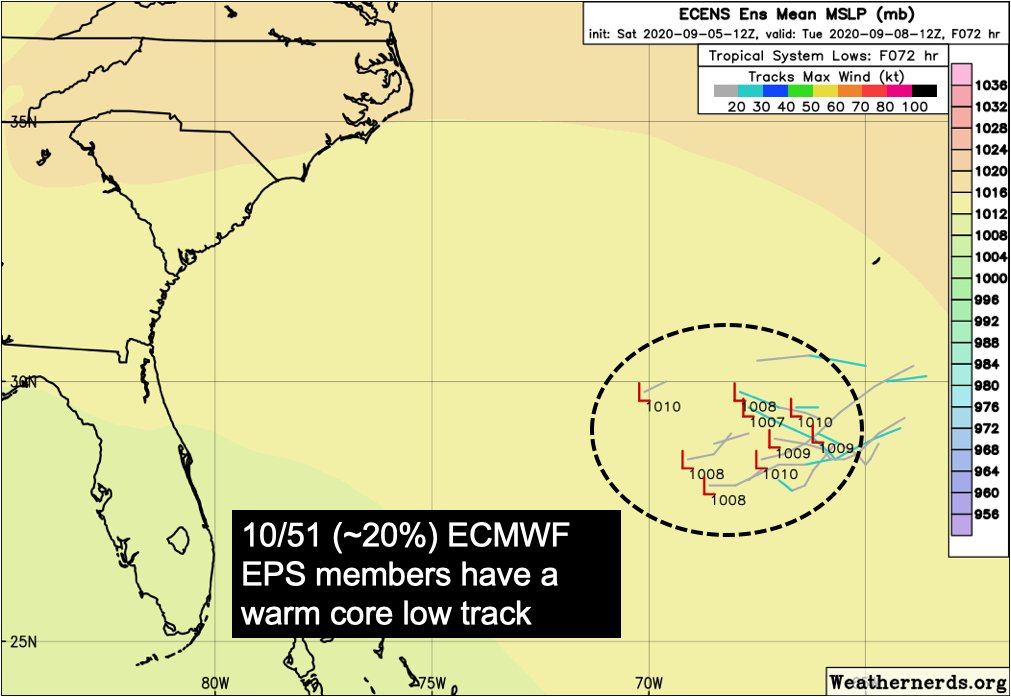
1) #Omar may now be post-tropical, but it left behind a trough that has remained convectively active & has now spawned a new low-level vortex.
This system will move slowly to the west & may organize further under low to moderate VWS & >28C SSTs over the next 2-4 days.
This system will move slowly to the west & may organize further under low to moderate VWS & >28C SSTs over the next 2-4 days.
There is growing model support representing this feature. The most recent 12z ECMWF EPS guidance had 10/51 (~20%) members with a warm core low track.
I don& #39;t think I need to reiterate how active this region between Bermuda & the East US Coast has been for #TC genesis this year.
I don& #39;t think I need to reiterate how active this region between Bermuda & the East US Coast has been for #TC genesis this year.
2) Making our way further south and west, we have this upper-level low that is migrating westward towards Florida.
Trough forcing for ascent has aided convective development within this upper-level low & may then encourage low-level vorticity generation if convection continues.
Trough forcing for ascent has aided convective development within this upper-level low & may then encourage low-level vorticity generation if convection continues.
This system has little model support right now, but is moving into a low VWS env. over the GoM the n/ 2-3 days.
Part of the why global model guidance fails to develop this system tied to lack of convection near llvl vorticity.
Keep a close eye in case convection overperforms.
Part of the why global model guidance fails to develop this system tied to lack of convection near llvl vorticity.
Keep a close eye in case convection overperforms.
3) Finally we make our way south & east into the Central Caribbean.
An easterly wave that originally stalled E of the Lesser Antilles ended up spawning a weak low-level vortmax that is now accelerating westward through Caribbean south of #Hispaniola.
An easterly wave that originally stalled E of the Lesser Antilles ended up spawning a weak low-level vortmax that is now accelerating westward through Caribbean south of #Hispaniola.
This system too has little to no model support for potential development & its small size makes it the most fragile of the bunch, susceptible to outflow boundaries collapsing the sfc vortmax.
Still though, if it survives to the NW Caribbean... it should be watched too.
Still though, if it survives to the NW Caribbean... it should be watched too.
Okay, I& #39;ve covered 3 systems in NATL existing now. Anything else to watch out for *not* currently existing? Yes.
An early season cold-surge may propagate into GoM, associated w/ same trough fcast to provide early season snow in CO.
This has been a past TCG pathway; Nate 2011.
An early season cold-surge may propagate into GoM, associated w/ same trough fcast to provide early season snow in CO.
This has been a past TCG pathway; Nate 2011.
So in short, almost too many things to keep track of. Again this thread ignores all the TC genesis possibilities out in the E NATL basin which are also plentiful.
Keep in mind we are 11 days ahead of 2005 pace if "P" named TC were to form Sunday. No break in sight...
fin.
Keep in mind we are 11 days ahead of 2005 pace if "P" named TC were to form Sunday. No break in sight...
fin.

 Read on Twitter


