Extreme weather setup this weekend for Europe with meandering #jetstream. Extreme #flooding around the Alps is inevitable. Strong tornadoes will be possible in Italy.
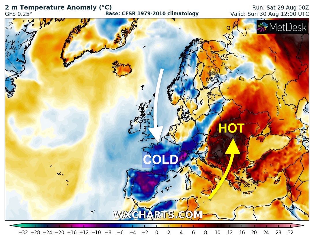
This pattern brings unusually cold conditions to Western Europe while Eastern Europe bakes in the heat.
[1/7]
This pattern brings unusually cold conditions to Western Europe while Eastern Europe bakes in the heat.
[1/7]
Rainfall totals around the Alps will be catastrophic for some places. #Flooding potential is huge.
Widespread 100-200 mm with some places expected to receive upwards of 300 mm. Over 500 mm locally will be possible by the end of Sunday.
Hotspot looks to be Swiss-Italian border.
Widespread 100-200 mm with some places expected to receive upwards of 300 mm. Over 500 mm locally will be possible by the end of Sunday.
Hotspot looks to be Swiss-Italian border.
@Estofex have issued a rare level 3 "for the southern Alpine flanks and the northern Po Valley, roughly from Milano to Pordenone (Friuli) for potentially STRONG TORNADOES, large hail, extreme rainfall, and damaging winds.
Details here: https://www.estofex.org/ ">https://www.estofex.org/">...
Details here: https://www.estofex.org/ ">https://www.estofex.org/">...
Also check out this post by @stormchaser_a81: https://twitter.com/stormchaser_a81/status/1299626043637149697
"Strong">https://twitter.com/stormchas... SW altitude jet between Balearic Islands and N Europe + hot air at the front in low layers: High risk of violent thunderstorms in #Italy... risk of "supercells and tornadoes in the Po plain".
"Strong">https://twitter.com/stormchas... SW altitude jet between Balearic Islands and N Europe + hot air at the front in low layers: High risk of violent thunderstorms in #Italy... risk of "supercells and tornadoes in the Po plain".
You can see the cool air pouring south through Western Europe as heat builds in the Balkans. Quite a contrast across the Alpine countries.
This is how the temperature nearer the surface compares to normal for this time of year.
Much colder than normal in the west and hot in the east. Note the thermal boundary close to the Alps. This is where we will see a lot of severe weather.
Much colder than normal in the west and hot in the east. Note the thermal boundary close to the Alps. This is where we will see a lot of severe weather.
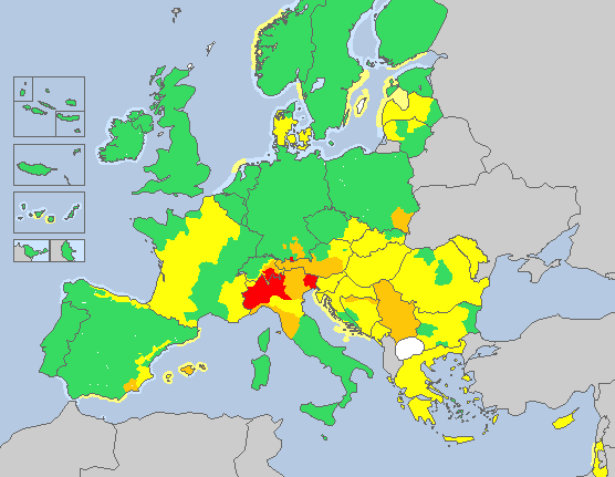
@MeteoalarmEu has numerous red warnings out around the Alpine countries.
More info here with interactive warning map: http://meteoalarm.eu/ ">https://meteoalarm.eu/">...
More info here with interactive warning map: http://meteoalarm.eu/ ">https://meteoalarm.eu/">...

 Read on Twitter


