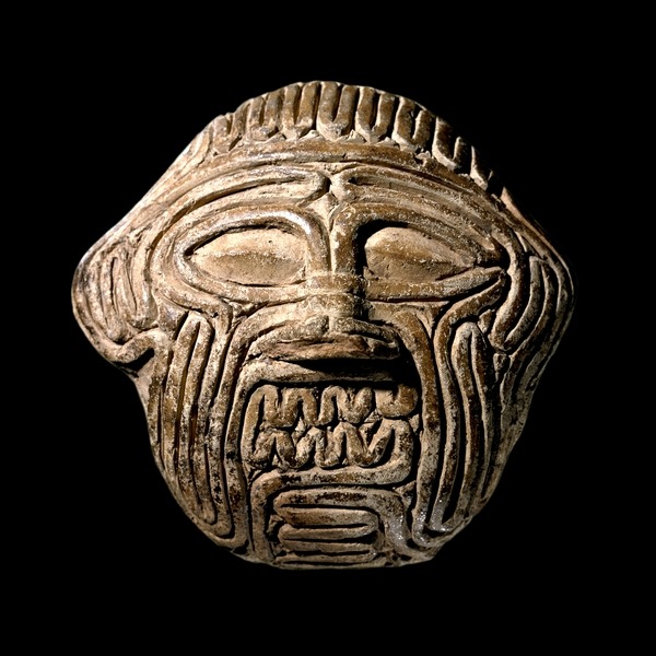
Thread: This mask currently held in the British museum depicts the grim face of Humbaba (Huwawa), legendary guardian of the Cedar Forest from Sumerian mythology. It is rendered in clay as if made of coils of a sheep’s intestines. The reason why is explained on the back:
"If the coils of the colon resemble the head of Huwawa, [this is] an omen of Sargon who ruled the land. If ...., the house of a man will expand. [Written by] the hand of Warad-Marduk, diviner, son of Kubburum, diviner"
Warad-Marduk lived in the city of Sippar (southern Iraq), around 1800–1600 BC. As a professional diviner, his job was to predict the future. The most common method for doing that in ancient Iraq was to study the shape and colour of the internal organs of a sacrificed sheep...
Each feature of the organs was thought to have meaning, a message from the gods. Health, size, colour and position of each organ was examined and the observed features and their meanings were compiled in long scholarly reference works...
And believe or not, a guy named Robert K. G. Temple actually went and checked these ancient descriptions of the sheep intestines and published his findings in https://www.jstor.org/stable/1359990 ">https://www.jstor.org/stable/13... Here is the pic of the intestines of a sick lamb from his book. Quite cool. Another spiral :)
So Warad-Marduk, the diviner from Sippar, saw Humbaba& #39;s face in the intestines...Which makes me ask this question: If you could see Humbaba& #39;s face in intestines, was Hunbaba& #39;s face imagined as stripy? This is kind of an important question...And you& #39;ll see why soon...
Huwawa features as a guardian of the ancient Cedar forest, in the & #39;Epic of Gilgamesh& #39;, where he was killed by Gilgamesh and Enkidu after which the ancient cedar forest was cut by their men....This story was told widely across the Middle East. So it must have been important...
Believe or not, we don& #39;t know for sure neither who or what Humbaba was, nor where the ancient Cedar forest was, nor if it was a forest of cedar trees at all...What we do know is that Sumerians cut the forest to get building material...And that they soon realised their mistake...
After they have killed Humbaba and have cut all the trees down:
302 [Enkidu] opened his mouth to speak, saying to Gilgameš:
303 “[My friend,] we have reduced the forest [to] a wasteland,
304 [how] shall we answer [God] Enlil in Nippur?
http://www.thehistoryblog.com/wp-content/uploads/2015/09/jcunestud.66.0069_w-footer.pdf">https://www.thehistoryblog.com/wp-conten...
The other day I came across this article https://www.jstor.org/stable/4200022 ">https://www.jstor.org/stable/42... by J. Hansman. In the article, the author tries to determine the location of the "Land of the Erin tree" which is what the Humbaba& #39;s forest was called in original manuscripts...And to identify the "Erin tree" itself
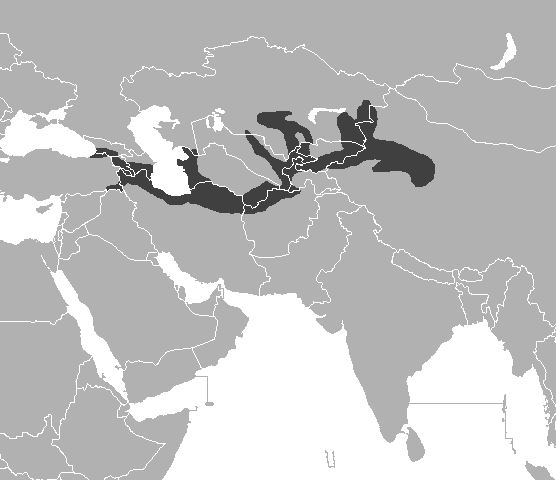
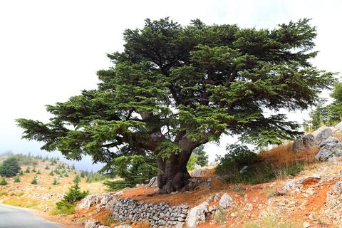
Most people identify Erin tree with Lebanese cedar https://en.wikipedia.org/wiki/Cedrus_libani">https://en.wikipedia.org/wiki/Cedr... And because of its historical distribution, they identify the Land of the Erin Trees as Mountains of Lebanon...Although as we can see the Distribution area also covers the whole of Southern Anatolia too...
But, Lebanon is in the west of Sumer. And the earliest mentions of the Erin forest place it in the east of Sumer. An old Sumerian text says "...When Utu (Sun) comes forth from the mountains perfumed by Erin trees"...
The Cedar Forest is the glorious realm of the gods of Mesopotamian mythology. And the mountains in the east, the same ones perfumed by the Erin trees, are called "Utu& #39;s living quarters" from which he emerges radiant and bright in the morning...
And before their departure for the Land of the Erin trees, Enkidu urges Gilgamesh to inform Utu of their intensions, as that land is his domain...After which Gilgamesh asks Utu to be his ally while he is in the land of the Erin trees...
And then, treacherously, Gilgamesh goes and kills Humbaba, whom Utu himself placed in his forest of Erin trees, to be its guardian...And after killing Humbaba, Gilgamesh cuts Utu& #39;s forest of Erin trees...So no more perfumed sunrises...When will gods learn not to trust humans???
So originally the Land of the Erin trees was located east of Sumer, in Zagros mountains of Western Iran. The problem here is that Lebanese cedar never grew in this part of the world. So originally Erin tree was not Lebanese cedar, and Erin forest was not a Cedar forest...
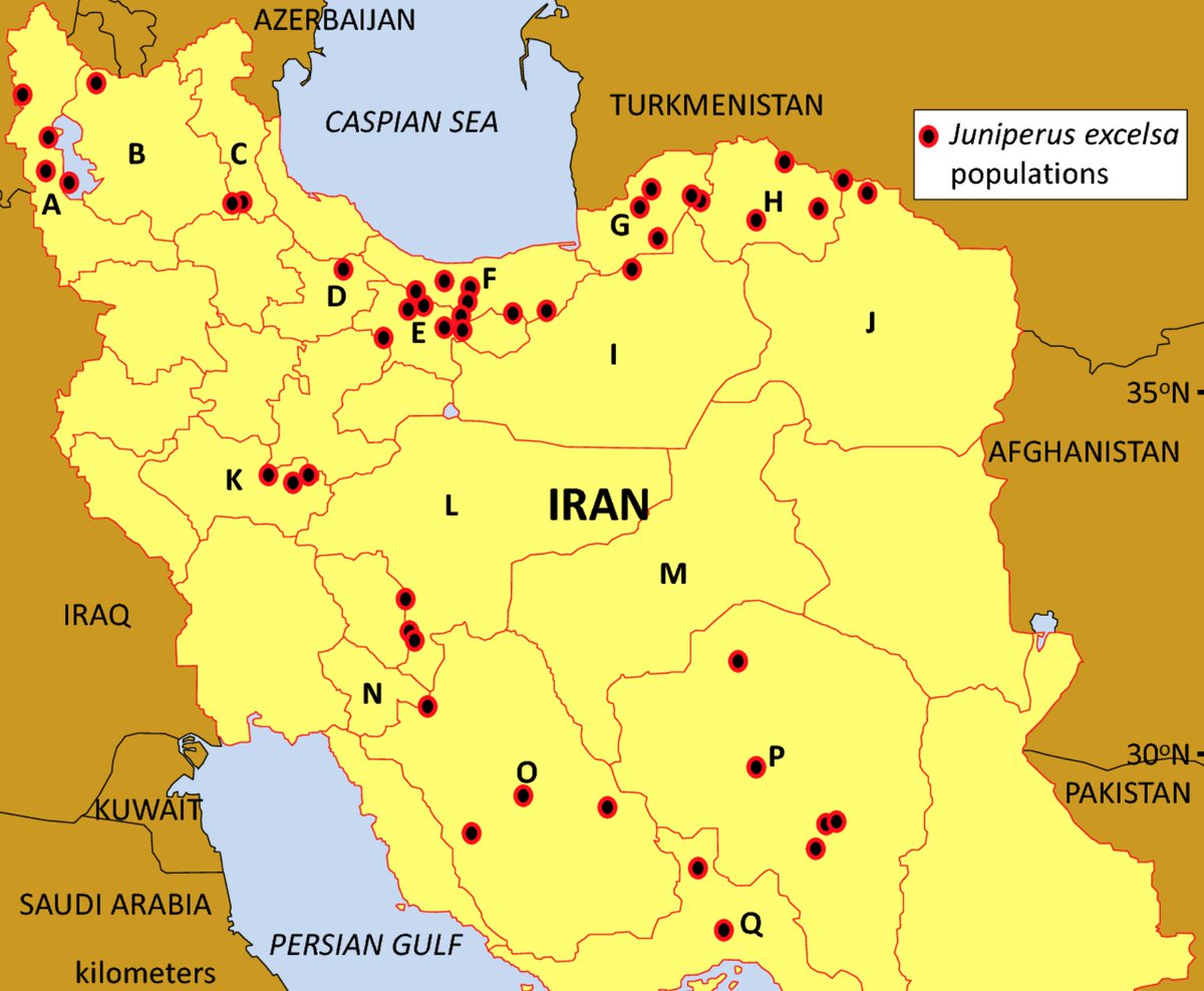
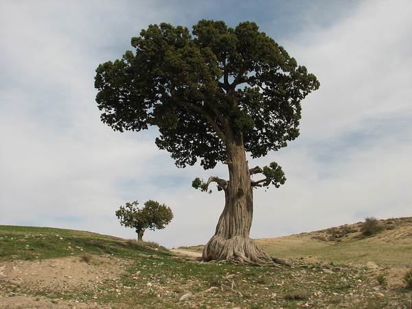
So what was Erin tree then? The author of the "Gilgamesh, Humbaba and the Land of the Erin-Trees" proposes that Erin tree was Juniperus excelsa, Greek or Persian juniper, which grows in Iran, Caucasus, Turkey, Syria and Lebanon...All around Iraq... https://en.wikipedia.org/wiki/Juniperus_excelsa">https://en.wikipedia.org/wiki/Juni...
Greek or Persian juniper wood is very fragrant and when burned gives off only minimal visible smoke, but this smoke is highly aromatic...And in the heat of the sun, these trees would indeed perfume the Utu& #39;s mountain...
Greek or Persian Juniper wood is also pale and the Sumerian texts describe the wood of the Erin trees as "white" or "of light colour"...So it all fits...Right? Well...
J. Hansman identifies Erin as Juniper because he identifies The Land of the Erin trees as Elam, and Greek or Persian juniper is "the only economically viable large conifer native to the mountains of the South-Western Iran...So...
But I have my doubts about this identification...
311 Gilgameš was cutting down the tree,
312 Enkidu was seeking out the best timber.
313 Enkidu opened his mouth to speak, saying to Gilgameš:
314 “My friend, we have cut down a lofty cedar,
315 whose top abutted the heavens...
311 Gilgameš was cutting down the tree,
312 Enkidu was seeking out the best timber.
313 Enkidu opened his mouth to speak, saying to Gilgameš:
314 “My friend, we have cut down a lofty cedar,
315 whose top abutted the heavens...
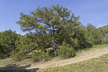
Juniperus excelsa is a "large shrub or tree" reaching 6–20 metres...Look at the shape of the tree canopy and the trunk. Very unlikely to be described as "tree whose top touches the heavens" or as a tree "of best building timber"...
Also, after they have cut the Erin trees down, Gilgamesh and Enkidu and their men lashed the trees together into rafts
320 . . . . . . branches […] cypress together with [… ,]
321 they lashed together a raft, they laid […]
Rafts? Well... https://en.wikipedia.org/wiki/Log_driving">https://en.wikipedia.org/wiki/Log_...
320 . . . . . . branches […] cypress together with [… ,]
321 they lashed together a raft, they laid […]
Rafts? Well... https://en.wikipedia.org/wiki/Log_driving">https://en.wikipedia.org/wiki/Log_...
Log driving was once the way to transport logs from the mountains where they were cut to the place where they were used...And there are several rivers flowing down from the Southern Zagros mountain westward...So Gilgamesh and Enkidu could have driven their logs down the river
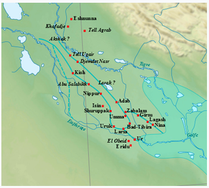
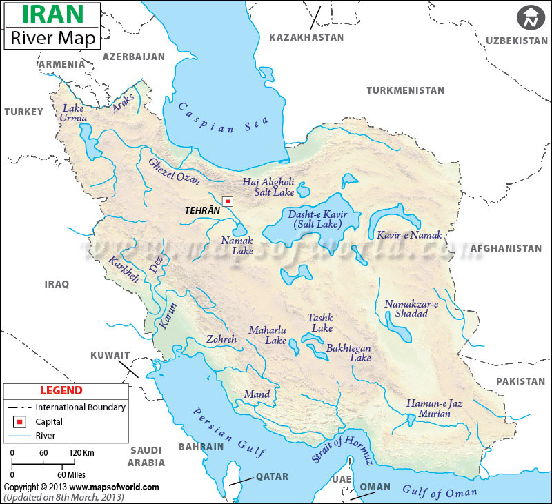
But there is one problem. Enkidu actually names the river which they used to transport the Erin tree logs from the Land of the Erin trees...And it& #39;s not any of the rivers flowing from the Southern Zagros mountains. And no, it& #39;s not any of the rivers flowing from Mt Lebanon either
318 Let the river Euphrates carry (it) to [Enlil in] Nippur,
319 [let Nippur’s] sanctuary [rejoice over it!]”
Wow! How did hunters for the location of the Land of the Erin trees miss this?
So...Where was the Land of the Erin trees, and what was Erin tree then?
319 [let Nippur’s] sanctuary [rejoice over it!]”
Wow! How did hunters for the location of the Land of the Erin trees miss this?
So...Where was the Land of the Erin trees, and what was Erin tree then?
Enters Inana: "My brother (Utu), awe-inspiring...lord of heaven...let me ride with you to the mountains; to the mountains of herbs, to the mountains of cedars, to the mountains; the mountains of cypresses...So far so good... http://etcsl.orinst.ox.ac.uk/cgi-bin/etcsl.cgi?text=t.4.32.f">https://etcsl.orinst.ox.ac.uk/cgi-bin/e...
And then it goes down hill for Elam and Lebanon: "...to the mountains of silver, the mountains of lapis lazuli...to the distant source of the rolling rivers, to the mountains"
Are these rolling rivers Tigris and Euphrates? I would say so, cause if the rivers were not named in Mesopotamia, then they are The Rivers: Tigris and Euphrates...It fits with what Enkidu said certainly, that the river they used to transport logs from Utu& #39;s mountain was Euphrates
Silver (found in Eastern Anatolia)? Lapis Lazuli (found in Afghanistan)? Who was supplying Sumer with these precious materials? Were they transported down Tigris and Euphrates? We know copper was, as Sumerian name for Euphrates means "copper river": https://oldeuropeanculture.blogspot.com/2016/12/ore.html">https://oldeuropeanculture.blogspot.com/2016/12/o...
This mention of Lapis being found in Utu& #39;s mountains is very interesting indeed. Cause apparently in Erin forest:
24 [Monkey mothers] sing aloud, a youngster monkey shrieks:
25 [like a band] of musicians and drummers,
26 daily they bash out a rhythm in the presence of Ḫ umbaba.
24 [Monkey mothers] sing aloud, a youngster monkey shrieks:
25 [like a band] of musicians and drummers,
26 daily they bash out a rhythm in the presence of Ḫ umbaba.
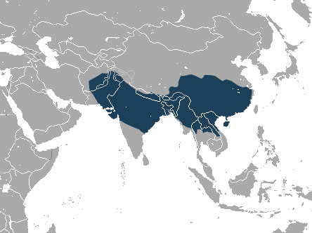
Meet Rhesus macaque. https://en.wikipedia.org/wiki/Rhesus_macaque">https://en.wikipedia.org/wiki/Rhes... It is native to among other places India, Bangladesh, Pakistan, Afghanistan...Afghanistan, the land of Lapis Lazuli...And just East of Afghanistan is Indus river valley...Hmmm...Is this a poetic freedom...
Well I would get back to that later. First...Is it possible that the Land of the Erin trees once in Eastern Anatolia? Around the source of Euphrates. Possibly. Apparently, during Bronze Age this land was covered in huge forests... https://www.jstor.org/stable/3642603 ">https://www.jstor.org/stable/36...
Sorry guys, have to go to make dinner. Hungry family...Will get back to this later...It& #39;s fun, isn& #39;t it?  https://abs.twimg.com/emoji/v2/... draggable="false" alt="🙂" title="Leicht lächelndes Gesicht" aria-label="Emoji: Leicht lächelndes Gesicht">
Ok food& #39;s cooking. Few short sneak tweets. So...Is it possible that the Land of the Erin trees was once in Eastern Anatolia? Around the source of Euphrates. Or East of it? It is. During Chalcolithic this land was covered in huge forests... https://www.jstor.org/stable/3642603 ">https://www.jstor.org/stable/36...
Well how old is the epic of Gilgamesh? Sumerian civilisation https://en.wikipedia.org/wiki/Sumer ">https://en.wikipedia.org/wiki/Sume... was preceded by Ubaid culture https://en.wikipedia.org/wiki/Ubaid_period">https://en.wikipedia.org/wiki/Ubai... which was preceded by Halaf culture https://en.wikipedia.org/wiki/Halaf_culture">https://en.wikipedia.org/wiki/Hala... And guess where Halaf culture was located? Wait. That& #39;s 6100 BC and 5100 BC!!!
How old are our epics? How long do they get transmitted orally before they are recorded for the first time? By the time writing was invented in Mesopotamia, people moved down south...And "East" and "Mountain of Utu" acquired different meaning...Back soon. Food...
Ok grilled sausages, tomato salad with oregano and feta cheese, French baguette and beer, done. Well beer still going, so excuse me if I say something stupid...
This is the area of the fertile crescent, c. 7500 BCE, with main Pre-Pottery Neolithic https://en.wikipedia.org/wiki/Pre-Pottery_Neolithic_B">https://en.wikipedia.org/wiki/Pre-... sites. The area of Mesopotamia proper was not yet settled by humans...
This is the same area, with relief. Look at the mountain that is east of this area. It& #39;s mount Ararat...Euphrates flows directly from it westward...Towards the centre of the populated area which lies between Taurus mountains and Kurdistan highlands...
What lies east from the area where we find the Pre-Pottery Neolithic B sites is very very interesting. It& #39;s the area full of mountainous forests, made of tall oaks and pines, and the eastern most known habitat of Caspian tigers. https://en.wikipedia.org/wiki/Caspian_tiger">https://en.wikipedia.org/wiki/Casp...
Well, based on 1900 records. Who wants to bet that around 6000 BC they lived further west and south? In the area of the upper Euphrates? Now remember my question about Humbaba& #39;s stripy face?
"His face is that of a lion. When he looks at someone, it is the look of death. Humbaba& #39;s roar is a flood, his mouth is death and his breath is fire! He can hear a hundred leagues away any [rustling?] in his forest! Who would go down into his forest!"
Now imagine going into the forests of the upper Euphrates to cut wood...Armed with stone axes...The forests of tall, straight https://en.wikipedia.org/wiki/Pinus_nigra,">https://en.wikipedia.org/wiki/Pinu... https://en.wikipedia.org/wiki/Pinus_brutia">https://en.wikipedia.org/wiki/Pinu... and Oaks, perfect for timber...But also forest full of tigers...
That would create some legends, right? Oh, by the way, the Greek/Persian Juniper also grows in this area...
By the time the legends were first recorded, the Sumerians were far away from the land of tigers...And so the true identity of Humbaba, the guardian of the Erin forest, was forgotten. Except for a bit about a stripy lion like head, roaring and all the other tiger like things...
But wait, does it mean that all these historians who say that Erin forest was located in Lebanon are talking crap? No. It doesn& #39;t. They are just quoting late Mesopotamian sources...The earliest identification of Lebanon as the source of Erin was from the 11th century BC...
To get timber to Euphrates from Lebanon, you have to transport them overland for 430km...Before that, since 2200BC, Mesopotamian record call Amanus Mountain in south eastern Turkey, the Erin mountain. From it you need to transport logs "only" 70 km overland to reach Euphrates...
Before that Zagros mountains were the Erin mountains...And before that, Armenian highlands were the Erin mountains...This is a tragic tale of human destruction of the environment...As more trees are cut down, people have to go further and further to find them and cut them...
And in doing so, they are destroying their environment more and more, turning once lush Erin forests into wastelands...Eventually only desert is left. Humbaba is gone, Erin trees are gone...

 Read on Twitter





![Also, after they have cut the Erin trees down, Gilgamesh and Enkidu and their men lashed the trees together into rafts320 . . . . . . branches […] cypress together with [… ,]321 they lashed together a raft, they laid […]Rafts? Well... https://en.wikipedia.org/wiki/Log_... Also, after they have cut the Erin trees down, Gilgamesh and Enkidu and their men lashed the trees together into rafts320 . . . . . . branches […] cypress together with [… ,]321 they lashed together a raft, they laid […]Rafts? Well... https://en.wikipedia.org/wiki/Log_...](https://pbs.twimg.com/media/EgCTOpjXYAIMhYr.jpg)
![318 Let the river Euphrates carry (it) to [Enlil in] Nippur,319 [let Nippur’s] sanctuary [rejoice over it!]”Wow! How did hunters for the location of the Land of the Erin trees miss this?So...Where was the Land of the Erin trees, and what was Erin tree then? 318 Let the river Euphrates carry (it) to [Enlil in] Nippur,319 [let Nippur’s] sanctuary [rejoice over it!]”Wow! How did hunters for the location of the Land of the Erin trees miss this?So...Where was the Land of the Erin trees, and what was Erin tree then?](https://pbs.twimg.com/media/EgCWL7gWoAAIjU7.jpg)

