
 Read on Twitter
Here’s the glorious multivallate Iron Age hillfort (and Roman fort) atop #HodHill #Dorset @nationaltrust  https://abs.twimg.com/emoji/v2/... draggable="false" alt="😍" title="Lächelndes Gesicht mit herzförmigen Augen" aria-label="Emoji: Lächelndes Gesicht mit herzförmigen Augen">looking east in this aerial photo from 2016 © Jo and Sue Crane
A thread to celebrate #HillfortsWednesday
A thread to celebrate #HillfortsWednesday
 looking east in this aerial photo from 2016 © Jo and Sue CraneA thread to celebrate #HillfortsWednesday" title="Here’s the glorious multivallate Iron Age hillfort (and Roman fort) atop #HodHill #Dorset @nationaltrust https://abs.twimg.com/emoji/v2/... draggable="false" alt="😍" title="Lächelndes Gesicht mit herzförmigen Augen" aria-label="Emoji: Lächelndes Gesicht mit herzförmigen Augen">looking east in this aerial photo from 2016 © Jo and Sue CraneA thread to celebrate #HillfortsWednesday" class="img-responsive" style="max-width:100%;"/>
Double ramparts define the 22ha hillfort of Hod Hill #Dorset except on the W with a single bank. Quarry pits form a line behind the ramparts. A Roman fort occupies the NW
Digital terrain model planlauf/TERRAIN from @HenryRothwell http://www.digitaldigging.net/hod-hill-dorset/
https://www.digitaldigging.net/hod-hill-... href="https://twtext.com//hashtag/HillfortsWednesday"> #HillfortsWednesday
Digital terrain model planlauf/TERRAIN from @HenryRothwell http://www.digitaldigging.net/hod-hill-dorset/
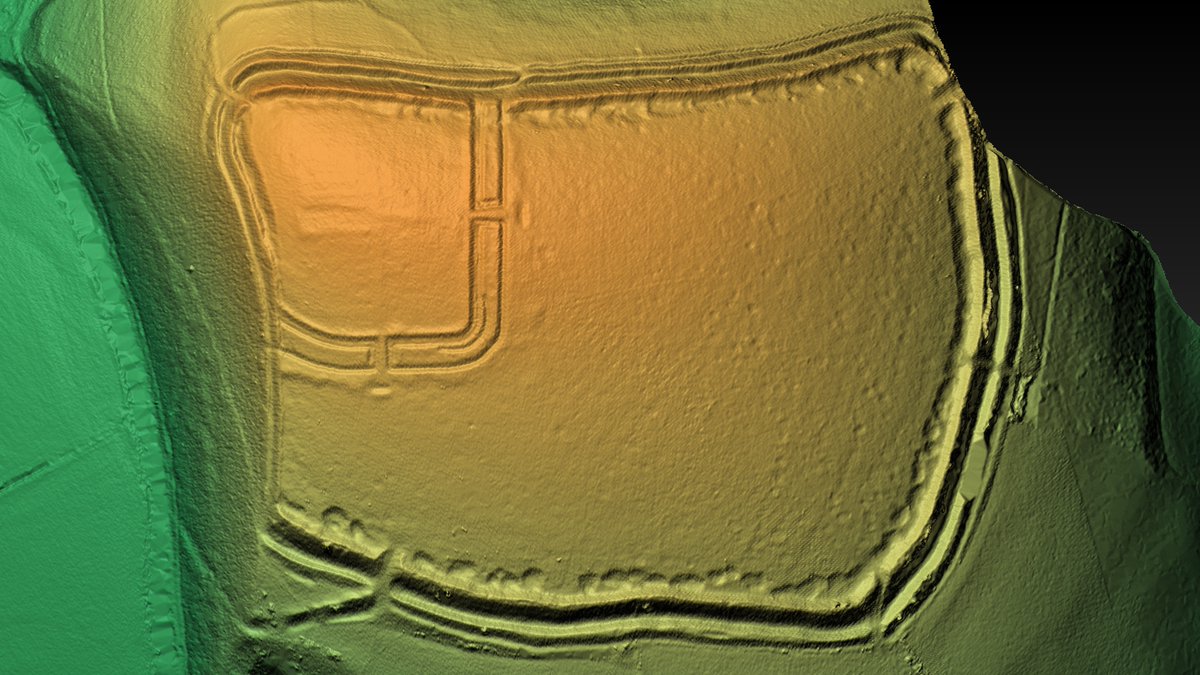 #HillfortsWednesday" title="Double ramparts define the 22ha hillfort of Hod Hill #Dorset except on the W with a single bank. Quarry pits form a line behind the ramparts. A Roman fort occupies the NWDigital terrain model planlauf/TERRAIN from @HenryRothwell https://www.digitaldigging.net/hod-hill-... href="https://twtext.com//hashtag/HillfortsWednesday"> #HillfortsWednesday" class="img-responsive" style="max-width:100%;"/>
The 2.6ha Roman fort at Hod Hill dates to c AD 44-52. It reused the N and W ramparts of the hillfort and was defended on its S and E sides by a rampart and 3 ditches
Excavations in 1951-8 revealed much of the internal structure
#HillfortsWednesday


Excavations in 1951-8 revealed much of the internal structure
#HillfortsWednesday
It was thought the Roman army built a fort on Hod Hill after laying siege to the Iron Age hillfort (as shown in this excellent reconstruction painting © Nick Skelton @nationaltrust)
Now it seems the hillfort was abandoned a good century before the Romans
#HillfortsWednesday
Now it seems the hillfort was abandoned a good century before the Romans #HillfortsWednesday")
Now it seems the hillfort was abandoned a good century before the Romans
#HillfortsWednesday
Excavations at Hod Hill found iron projectiles from a Roman ballista. Ian Richmond thought these had been fired into the hillfort during a siege. It seems more likely they were fired from the Roman fort during catapult practice
Ballistae © Mariusz Kozik
#HillfortsWednesday

Ballistae © Mariusz Kozik
#HillfortsWednesday
Most discussion of Hod Hill #Dorset @nationaltrust centres on the death of the Iron Age hillfort. We wanted to focus on its life, therefore conducted a geophysical survey of the interior
Here it ishttps://abs.twimg.com/emoji/v2/... draggable="false" alt="🤩" title="Vom Star geblendet" aria-label="Emoji: Vom Star geblendet">
© Dave Stewart and Bournemouth University #HillfortsWednesday #LoveGeofiz
Here it is
© Dave Stewart and Bournemouth University #HillfortsWednesday #LoveGeofiz
 © Dave Stewart and Bournemouth University #HillfortsWednesday #LoveGeofiz" title="Most discussion of Hod Hill #Dorset @nationaltrust centres on the death of the Iron Age hillfort. We wanted to focus on its life, therefore conducted a geophysical survey of the interiorHere it is https://abs.twimg.com/emoji/v2/... draggable="false" alt="🤩" title="Vom Star geblendet" aria-label="Emoji: Vom Star geblendet">© Dave Stewart and Bournemouth University #HillfortsWednesday #LoveGeofiz" class="img-responsive" style="max-width:100%;"/>
The most striking features on our geofiz of Hod Hill are the 10-15m diameter Iron Age roundhouses which are so densely packed that they often overlap
Some are set within enclosures. All cluster alongside a road system that branches out from the NE gatehttps://abs.twimg.com/emoji/v2/... draggable="false" alt="😍" title="Lächelndes Gesicht mit herzförmigen Augen" aria-label="Emoji: Lächelndes Gesicht mit herzförmigen Augen">
#HillfortsWednesday
Some are set within enclosures. All cluster alongside a road system that branches out from the NE gate
#HillfortsWednesday
 #HillfortsWednesday" title="The most striking features on our geofiz of Hod Hill are the 10-15m diameter Iron Age roundhouses which are so densely packed that they often overlapSome are set within enclosures. All cluster alongside a road system that branches out from the NE gate https://abs.twimg.com/emoji/v2/... draggable="false" alt="😍" title="Lächelndes Gesicht mit herzförmigen Augen" aria-label="Emoji: Lächelndes Gesicht mit herzförmigen Augen"> #HillfortsWednesday" class="img-responsive" style="max-width:100%;"/>
The so-called chieftain’s hut at Hod Hill #Dorset which was thought had been the target of a Roman artillery attack, was not the largest enclosed house built inside the hillfort as the geophysical survey shows
Sometimes we spend hours looking at this plothttps://abs.twimg.com/emoji/v2/... draggable="false" alt="😊" title="Lächelndes Gesicht mit lächelnden Augen" aria-label="Emoji: Lächelndes Gesicht mit lächelnden Augen">
#HillfortsWednesday
Sometimes we spend hours looking at this plot
#HillfortsWednesday
 #HillfortsWednesday" title="The so-called chieftain’s hut at Hod Hill #Dorset which was thought had been the target of a Roman artillery attack, was not the largest enclosed house built inside the hillfort as the geophysical survey showsSometimes we spend hours looking at this plot https://abs.twimg.com/emoji/v2/... draggable="false" alt="😊" title="Lächelndes Gesicht mit lächelnden Augen" aria-label="Emoji: Lächelndes Gesicht mit lächelnden Augen"> #HillfortsWednesday">
 #HillfortsWednesday" title="The so-called chieftain’s hut at Hod Hill #Dorset which was thought had been the target of a Roman artillery attack, was not the largest enclosed house built inside the hillfort as the geophysical survey showsSometimes we spend hours looking at this plot https://abs.twimg.com/emoji/v2/... draggable="false" alt="😊" title="Lächelndes Gesicht mit lächelnden Augen" aria-label="Emoji: Lächelndes Gesicht mit lächelnden Augen"> #HillfortsWednesday">
 #HillfortsWednesday" title="The so-called chieftain’s hut at Hod Hill #Dorset which was thought had been the target of a Roman artillery attack, was not the largest enclosed house built inside the hillfort as the geophysical survey showsSometimes we spend hours looking at this plot https://abs.twimg.com/emoji/v2/... draggable="false" alt="😊" title="Lächelndes Gesicht mit lächelnden Augen" aria-label="Emoji: Lächelndes Gesicht mit lächelnden Augen"> #HillfortsWednesday">
Tantalising close ups of our geophysical survey inside Hod Hill
An Iron Age roundhouse with gulley, internal post ring, storage pits, hearth and SE facing entrance
A section of road bordered by rows of 4 post structures - (possibly granaries)
#HillfortsWednesday #LoveGeofiz
 #HillfortsWednesday #LoveGeofiz")
 #HillfortsWednesday #LoveGeofiz")
An Iron Age roundhouse with gulley, internal post ring, storage pits, hearth and SE facing entrance
A section of road bordered by rows of 4 post structures - (possibly granaries)
#HillfortsWednesday #LoveGeofiz
Hod Hill #Dorset for #HillfortsWednesday:
The view to the North of the Iron Age ramparts to the Iwerne Valley and the view NW to the River Stour
Proper lovelyhttps://abs.twimg.com/emoji/v2/... draggable="false" alt="😍" title="Lächelndes Gesicht mit herzförmigen Augen" aria-label="Emoji: Lächelndes Gesicht mit herzförmigen Augen">https://abs.twimg.com/emoji/v2/... draggable="false" alt="😍" title="Lächelndes Gesicht mit herzförmigen Augen" aria-label="Emoji: Lächelndes Gesicht mit herzförmigen Augen">
The view to the North of the Iron Age ramparts to the Iwerne Valley and the view NW to the River Stour
Proper lovely
 https://abs.twimg.com/emoji/v2/... draggable="false" alt="😍" title="Lächelndes Gesicht mit herzförmigen Augen" aria-label="Emoji: Lächelndes Gesicht mit herzförmigen Augen">" title="Hod Hill #Dorset for #HillfortsWednesday:The view to the North of the Iron Age ramparts to the Iwerne Valley and the view NW to the River StourProper lovely https://abs.twimg.com/emoji/v2/... draggable="false" alt="😍" title="Lächelndes Gesicht mit herzförmigen Augen" aria-label="Emoji: Lächelndes Gesicht mit herzförmigen Augen">https://abs.twimg.com/emoji/v2/... draggable="false" alt="😍" title="Lächelndes Gesicht mit herzförmigen Augen" aria-label="Emoji: Lächelndes Gesicht mit herzförmigen Augen">">
 https://abs.twimg.com/emoji/v2/... draggable="false" alt="😍" title="Lächelndes Gesicht mit herzförmigen Augen" aria-label="Emoji: Lächelndes Gesicht mit herzförmigen Augen">" title="Hod Hill #Dorset for #HillfortsWednesday:The view to the North of the Iron Age ramparts to the Iwerne Valley and the view NW to the River StourProper lovely https://abs.twimg.com/emoji/v2/... draggable="false" alt="😍" title="Lächelndes Gesicht mit herzförmigen Augen" aria-label="Emoji: Lächelndes Gesicht mit herzförmigen Augen">https://abs.twimg.com/emoji/v2/... draggable="false" alt="😍" title="Lächelndes Gesicht mit herzförmigen Augen" aria-label="Emoji: Lächelndes Gesicht mit herzförmigen Augen">">
More of Hod Hill #Dorset for #HillfortsWednesday https://abs.twimg.com/emoji/v2/... draggable="false" alt="🤩" title="Vom Star geblendet" aria-label="Emoji: Vom Star geblendet">:
the northern bivallate ramparts of the hillfort looking East;
the Eastern circuit of the Roman fort where it intersects with the Iron Age earthworks;
the Southern inner scarp with quarry pits
the northern bivallate ramparts of the hillfort looking East;
the Eastern circuit of the Roman fort where it intersects with the Iron Age earthworks;
the Southern inner scarp with quarry pits
 : the northern bivallate ramparts of the hillfort looking East;the Eastern circuit of the Roman fort where it intersects with the Iron Age earthworks;the Southern inner scarp with quarry pits" title="More of Hod Hill #Dorset for #HillfortsWednesday https://abs.twimg.com/emoji/v2/... draggable="false" alt="🤩" title="Vom Star geblendet" aria-label="Emoji: Vom Star geblendet">: the northern bivallate ramparts of the hillfort looking East;the Eastern circuit of the Roman fort where it intersects with the Iron Age earthworks;the Southern inner scarp with quarry pits">
 : the northern bivallate ramparts of the hillfort looking East;the Eastern circuit of the Roman fort where it intersects with the Iron Age earthworks;the Southern inner scarp with quarry pits" title="More of Hod Hill #Dorset for #HillfortsWednesday https://abs.twimg.com/emoji/v2/... draggable="false" alt="🤩" title="Vom Star geblendet" aria-label="Emoji: Vom Star geblendet">: the northern bivallate ramparts of the hillfort looking East;the Eastern circuit of the Roman fort where it intersects with the Iron Age earthworks;the Southern inner scarp with quarry pits">
 : the northern bivallate ramparts of the hillfort looking East;the Eastern circuit of the Roman fort where it intersects with the Iron Age earthworks;the Southern inner scarp with quarry pits" title="More of Hod Hill #Dorset for #HillfortsWednesday https://abs.twimg.com/emoji/v2/... draggable="false" alt="🤩" title="Vom Star geblendet" aria-label="Emoji: Vom Star geblendet">: the northern bivallate ramparts of the hillfort looking East;the Eastern circuit of the Roman fort where it intersects with the Iron Age earthworks;the Southern inner scarp with quarry pits">
Gates that pierce the circuit of Iron Age ramparts on Hod Hill in #Dorset:
the Steepleton Gate (Iron Age) in the NE;
the Water Gate (Roman) in the NW;
the Home Gate (medieval) in the SE
Happy #HillfortsWednesday everyone !
 in the NE; the Water Gate (Roman) in the NW; the Home Gate (medieval) in the SEHappy #HillfortsWednesday everyone !")
 in the NE; the Water Gate (Roman) in the NW; the Home Gate (medieval) in the SEHappy #HillfortsWednesday everyone !")
 in the NE; the Water Gate (Roman) in the NW; the Home Gate (medieval) in the SEHappy #HillfortsWednesday everyone !")
the Steepleton Gate (Iron Age) in the NE;
the Water Gate (Roman) in the NW;
the Home Gate (medieval) in the SE
Happy #HillfortsWednesday everyone !


