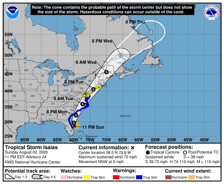
Here’s my first call #TropicalStormIsaias impact thoughts. Based off of latest guidance and NHC forecast track. Remember, I cover a large area not just your house. So I will be posting general impacts that we will feel from Coastal CT to NW New Jersey and areas in between...
Sustained Winds: 30-50MPH Gusts 60+
Coastal Flooding: Minor impact
Rainfall: 2-4” with locally higher amounts of 5-6” in spots
Tornado/Waterspout: Low risk. An isolated tornado or waterspout can’t be ruled out
Inland Flooding: Moderate Risk. For those spots that get in on...
Coastal Flooding: Minor impact
Rainfall: 2-4” with locally higher amounts of 5-6” in spots
Tornado/Waterspout: Low risk. An isolated tornado or waterspout can’t be ruled out
Inland Flooding: Moderate Risk. For those spots that get in on...
some of the heavier bands of rain. Especially if there is any type of training of heavy rain bands. Areas of poor drainage and low lying could be susceptible to flooding even with lower end amounts.
Timing: First rain bands will move in late morning Tuesday the storm...
Timing: First rain bands will move in late morning Tuesday the storm...
should exit the region Midnight-3AM Wednesday. It will be a bit breezy in the wake of this storm on Wednesday.
This thread is more straightforward than previous because we have a good feeling about the track now, and strength. If there is anything I might have missed, please...
This thread is more straightforward than previous because we have a good feeling about the track now, and strength. If there is anything I might have missed, please...
Feel free to ask. I’ll be more than happy to ask. I can’t give you a zip code forecast though. I cover a large area. If you are in my forecast area prepare for the conditions in the above tweets. I’ll have a final impact forecast tomorrow after 5PM advisory. I could tweak a...
few little things based on guidance then. But I don’t anticipate any major shifts in overall idea. What you see is what I believe we’ll get. I would advise bringing in, or tying down, any objects around your house, or apartment that could become a flying projectile from high...
winds. Finally, this is the most important thing, STAY CALM! This is not a Sandy, not even close. This will be very similar to Fay, but not identical. Tropical systems are like snowflakes. No two are identical. So don’t base this one off of any previous storms. I’m sure...
Someone will tweet me Tuesday or Wednesday that they saw something they never saw in a storm before. It’s how these things go. The most important thing is I don’t anticipate any widespread destruction, flooding, or power outages. Again, a few will experience one or more of...
those things. Especially if you have with past storms. But we’ve definitely recently saw nor’easters that packed a bigger punch than #Isais Will locally. But don’t take it lightly either and act like it’s no big deal. Respect the storm, don’t fear it. Especially this one.

 Read on Twitter


