I would not be surprised to see #Isaias regain at least a little strength (vs its realistic intensity now which is likely ~50 kt based on recon) before its arrival in/near central FL, though IMHO max winds likely stay just below hurr intensity and stgest winds remain offshore.
Dry slot (at 700-400 mb) starts filling in tonight into early Sun, but more significantly Sun night into Mon. Because of this improved environ. + #Isaias moving ~parallel to shear vector, I would not be surprised to see it intensify quickly to a cat 1 before landfalling in SC/NC.
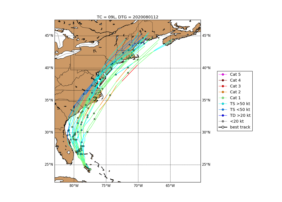
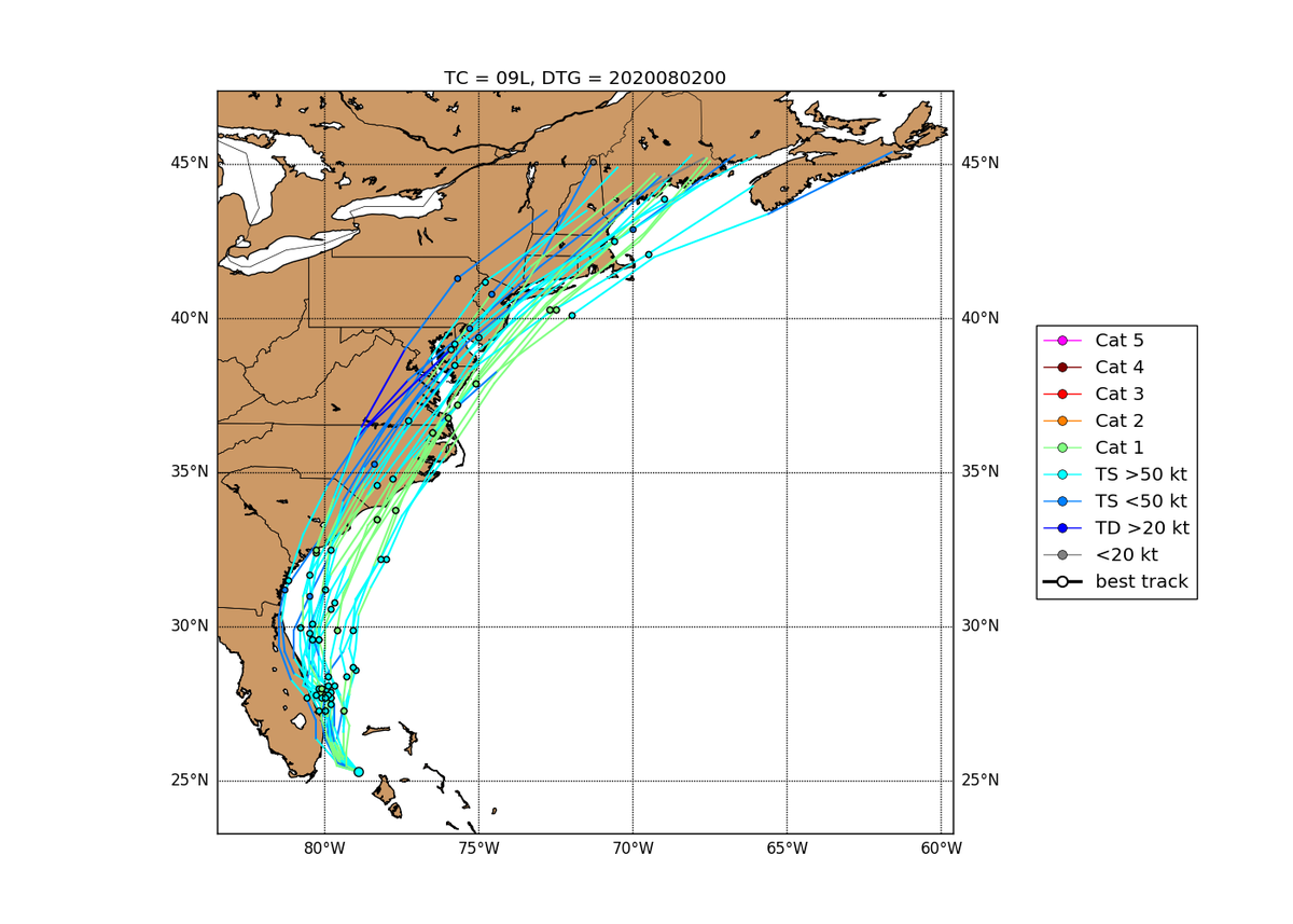
Update from my previous post - #Isaias jogged NNW in past few hours since its convective burst, such that NHC 12z position for #Isaias is about 30 mi ESE of their 12 forecast from last night, and also similarly east of most guidance from 12z Sat. Note short-term E trend from GFS.
If #Isaias can stay east of about 80.3W (i.e. signif. distance off NE FL coast), that increases by 6-12 hours the amt. of time it has to take advantage of moistening profile and very warm water off SE US coast, and https://abs.twimg.com/emoji/v2/... draggable="false" alt="⬆️" title="Pfeil nach oben" aria-label="Emoji: Pfeil nach oben">risk of strengthening prior to NC/SC landfall mentioned before.
Also not counting out potential for signif. wind damage and at least some damage from storm surge/coastal flooding along mid-Atl coast from SE VA all the way up to southern/eastern NJ, Long Island and portions of S. New England. Track just inland from mid-Atl coast is dangerous.
While a hurricane tracking inland for 24 hours would normally weaken, a few factors may help #Isaias maintain a core of damaging winds all the way up to Long Island/New England.
Firstly, #Isaias being in right-rear quadrant of a strengthening and increasingly neg. tilt jet streak from c. Appalachians to SE Canada would promote upward motion and provide baroclinic support to help maintain convection near its center (even if it transitions to non-tropical)
This paper on Hurricane Irene& #39;s intensification just off NE US/SE Canada coast in Oct 1999 details the support provided by proper positioning of jet streaks for a hurricane during extratropical transition: https://journals.ametsoc.org/mwr/article/132/6/1355/67131">https://journals.ametsoc.org/mwr/artic... Anyone know of other good papers on this topic?
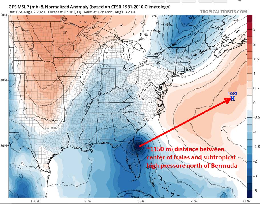
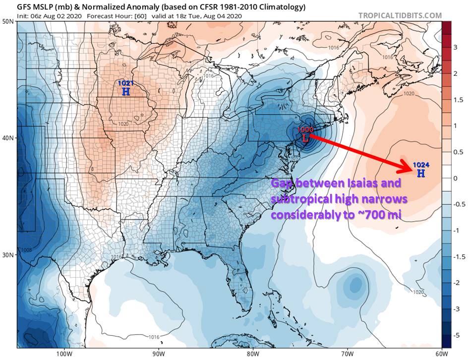
Another factor that could help maintain strong winds well E of Isaias& #39;s track as it reaches the NE US is strengthening pressure gradient between the hurricane and subtropical high N of Bermuda, as Isaias gets increasingly closer to the high (my graphics are simplified, of course)
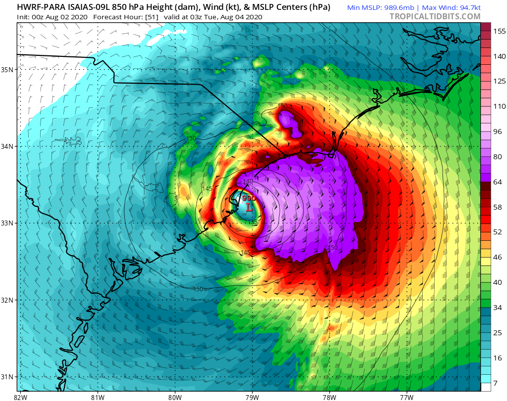
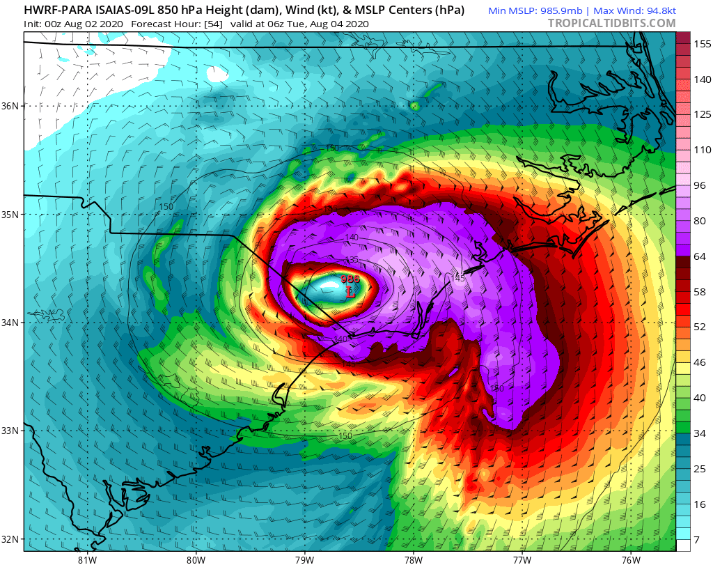
Notice the core winds in the at 850 mb east of #Isaias& #39;s track even increase slightly as it tracks from Carolinas to NJ/NY, and the area of 65+ kt winds (purple colors) expands in area dramatically. The second aspect is typical for an extratropical transitioning hurricane.
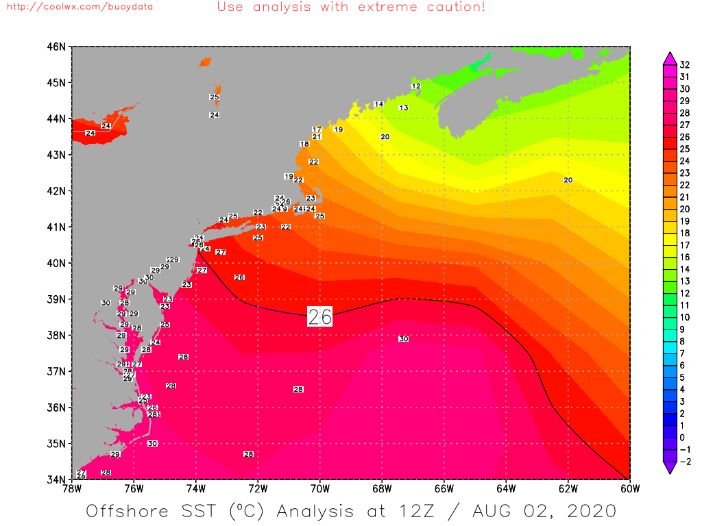
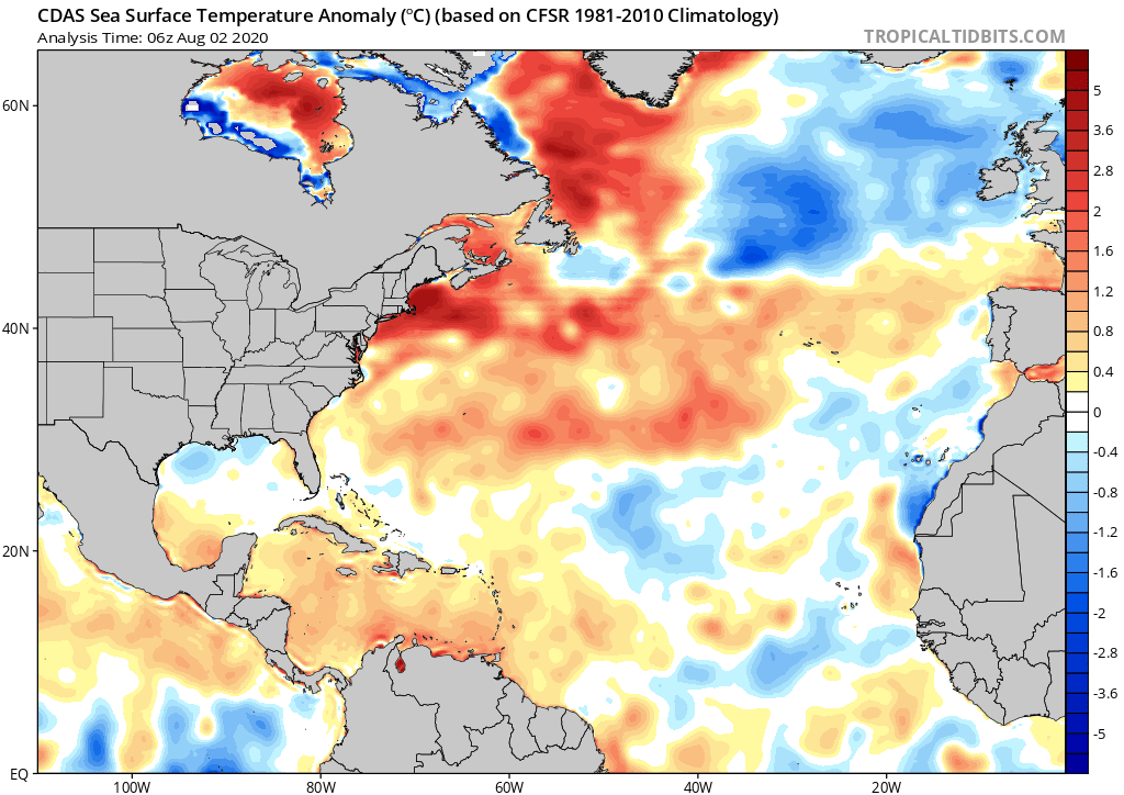
The well above normal SSTs off the NE US coast, particularly in Chesapeake and Delaware Bays and just south of LI, won& #39;t hurt #Isaias& #39;s chances of maintaining organization as it tracks just inland of mid-Atlantic/New England coast.
A final factor to consider is #Isaias& #39;s N-ward acceleration will add power to winds E of its track. This factor played a major role in wind/surge damage from infamous canes in NE US history e.g 1821, 1938, Carol (though I don& #39;t expect Isaias impacts to be anywhere near these).
Isaias& #39;s forward speed is expected to accelerate from 20-25 mph near Carolinas to ~35 mph by the time it reaches the latitude of Long Island/southern New England. Most of the canes that hit LI/New England hardest had forward speeds of at least 40 mph, including 1938 and Carol.

 Read on Twitter
 risk of strengthening prior to NC/SC landfall mentioned before." title="If #Isaias can stay east of about 80.3W (i.e. signif. distance off NE FL coast), that increases by 6-12 hours the amt. of time it has to take advantage of moistening profile and very warm water off SE US coast, andhttps://abs.twimg.com/emoji/v2/... draggable="false" alt="⬆️" title="Pfeil nach oben" aria-label="Emoji: Pfeil nach oben">risk of strengthening prior to NC/SC landfall mentioned before.">
 risk of strengthening prior to NC/SC landfall mentioned before." title="If #Isaias can stay east of about 80.3W (i.e. signif. distance off NE FL coast), that increases by 6-12 hours the amt. of time it has to take advantage of moistening profile and very warm water off SE US coast, andhttps://abs.twimg.com/emoji/v2/... draggable="false" alt="⬆️" title="Pfeil nach oben" aria-label="Emoji: Pfeil nach oben">risk of strengthening prior to NC/SC landfall mentioned before.">
 risk of strengthening prior to NC/SC landfall mentioned before." title="If #Isaias can stay east of about 80.3W (i.e. signif. distance off NE FL coast), that increases by 6-12 hours the amt. of time it has to take advantage of moistening profile and very warm water off SE US coast, andhttps://abs.twimg.com/emoji/v2/... draggable="false" alt="⬆️" title="Pfeil nach oben" aria-label="Emoji: Pfeil nach oben">risk of strengthening prior to NC/SC landfall mentioned before.">
 risk of strengthening prior to NC/SC landfall mentioned before." title="If #Isaias can stay east of about 80.3W (i.e. signif. distance off NE FL coast), that increases by 6-12 hours the amt. of time it has to take advantage of moistening profile and very warm water off SE US coast, andhttps://abs.twimg.com/emoji/v2/... draggable="false" alt="⬆️" title="Pfeil nach oben" aria-label="Emoji: Pfeil nach oben">risk of strengthening prior to NC/SC landfall mentioned before.">
