You’ve probably recently seen a lot of people cycling around on the streets  https://abs.twimg.com/emoji/v2/... draggable="false" alt="🛣" title="Autobahn" aria-label="Emoji: Autobahn">, or on Instagram
  https://abs.twimg.com/emoji/v2/... draggable="false" alt="📸" title="Kamera mit Blitz" aria-label="Emoji: Kamera mit Blitz">. You’ve also seen the obnoxious types who have a Vigo trailing behind them as they cycle
  https://abs.twimg.com/emoji/v2/... draggable="false" alt="🚴🏽" title="Person biking (mittlerer Hautton)" aria-label="Emoji: Person biking (mittlerer Hautton)">
 https://abs.twimg.com/emoji/v2/... draggable="false" alt="🚗" title="Auto" aria-label="Emoji: Auto">. Is this a fad that will disappear? Or is this here to stay in Pakistan?
Luckily for us, most of these outdoor enthusiasts log/record their activities using mobile apps. One of those apps, @Strava, converts last 2 years of data into heat maps, and shares publicly. I dug into the maps for #Karachi to see what it says about this cycling & running trend.
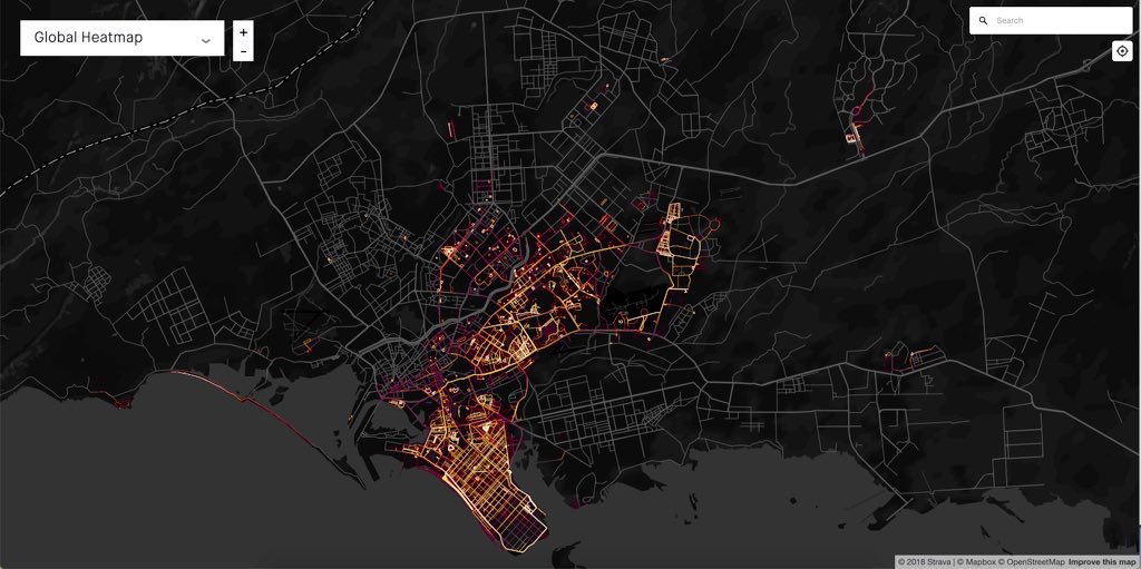
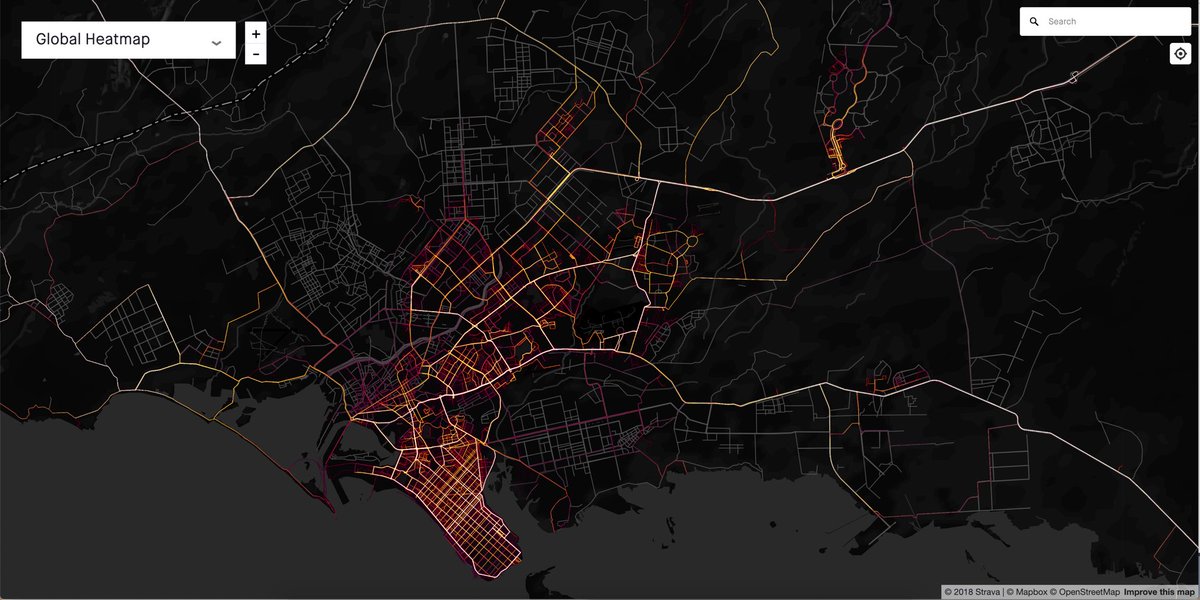
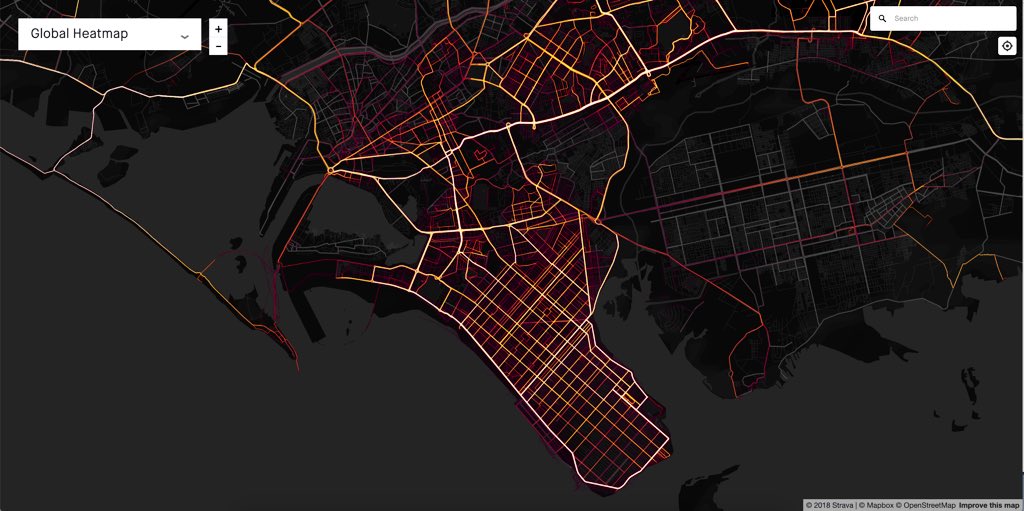
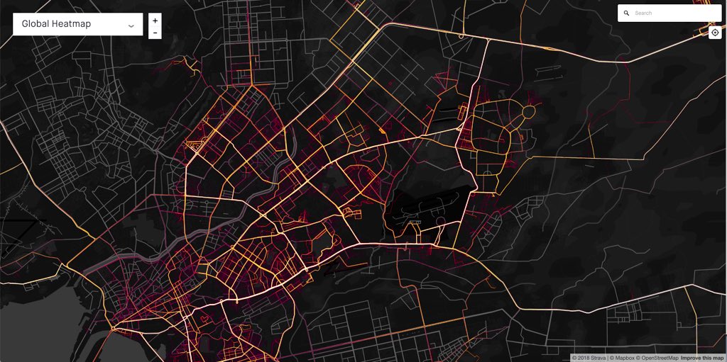
This is Karachi’s cycling heat map. Most of the logged activity is in East and South: Gulshan, Johar, PECHS, Clifton & DHA. Some activity in Malir Cantt and Bahria Town. Except DHA, cycling happening on major roads: SEFaisal, Uni Rd, Karsaz, Mai Kolachi etc.
Ofc: major caveat. This is leisure activity recorded on mobile phones. Therefore this says more about neighbourhoods/areas/roads that are financially well off, and considered “safe” to cycle around by wealthier (almost all) men.
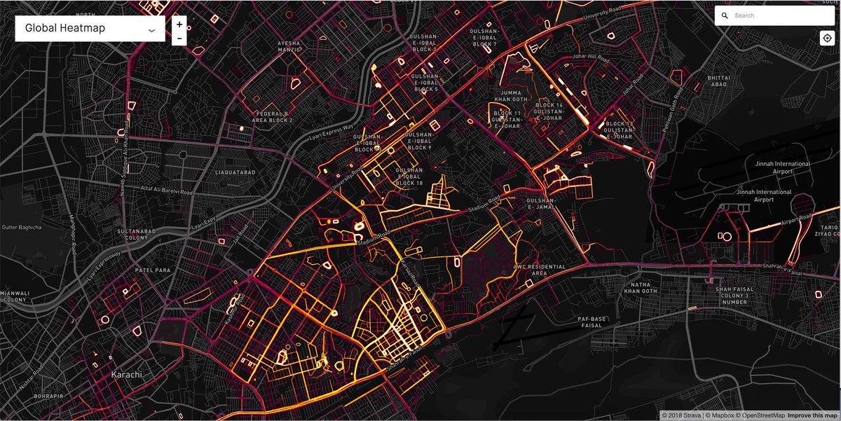
You can zoom in and see the most popular roads: Main Clifton (Metropole to Park Towers), Mai Kolachi to Korangi Rd, Sea View Road, Kh-e-Ittehad etc. No surprises. If you want to start cycling, pick any of these.
But here is the important point. It is equally happening in PECHS, Gulshan, North Nazimabad, Johar & Malir. When the conversation happens around building bicycle infrastructure, let’s not ignore all these areas. For residents here, we have a cycling community too  https://abs.twimg.com/emoji/v2/... draggable="false" alt="🙌🏽" title="Raising hands (mittlerer Hautton)" aria-label="Emoji: Raising hands (mittlerer Hautton)">
Now, running  https://abs.twimg.com/emoji/v2/... draggable="false" alt="🏃🏽" title="Person running (mittlerer Hautton)" aria-label="Emoji: Person running (mittlerer Hautton)">
 https://abs.twimg.com/emoji/v2/... draggable="false" alt="🏃🏽♂️" title="Läufer (mittlerer Hautton)" aria-label="Emoji: Läufer (mittlerer Hautton)">
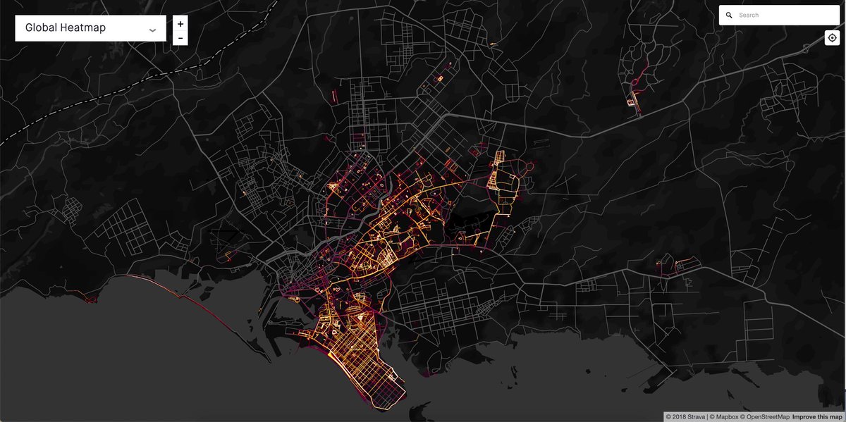
 https://abs.twimg.com/emoji/v2/... draggable="false" alt="🏃🏽♀️" title="Läuferin (mittlerer Hautton)" aria-label="Emoji: Läuferin (mittlerer Hautton)">. When you switch to the running-only heat map, a slightly different city emerges. This one is mostly WITHIN neighbourhoods, as opposed to major roads.
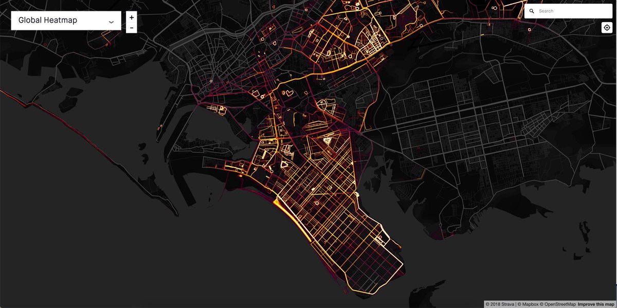
Zoom into south, and people seem to run on the streets in DHA, KDA and some parts of PECHS too. Perceptions of security on the streets, maybe? Sea View is a bright spot, ofc, and the Korangi Creek side road in Phase 8. There’s some real runners in Mohammad Ali too!
Zoom in and you start seeing the popular, well used parks: Nisar Shaheed, Zamzama, Hilal, Amir Khusro, Aunty Park. Lots of running inside Naval colony in Zamzama. The new green belt in Clifton Block 2 seems to be heating up with running activity as well!
Fewer large parks in East & Central, so folks are running mostly in the streets. I can spot Hill Park, Jheel Park, and ofc lots of smaller neighbourhood parks. Need more parks here! Roads around airport are also a popular spot.
Cool maps, no? Not quite. Ultimately, this is also a map of the city’s inequality, set in concrete, & illuminated by trailing sparks of privilege & wealth. Look at all the dark areas. What are they doing for healthy leisure in public spaces?
Sure, they may not be recording their activity on @Strava (and they don’t have to). But we really have to bury our head into the sand to not acknowledge that this is an issue of class and gender inequality. What does your city’s map of inequality look like?  https://abs.twimg.com/emoji/v2/... draggable="false" alt="🗺" title="Weltkarte" aria-label="Emoji: Weltkarte">
I’d love for folks in other cities to share their city’s maps, and their insights on those patterns. Only a grounded local would know how to interpret them. Search for Strava’s Global Heat Maps. It’s public.

 Read on Twitter
 " title="But here is the important point. It is equally happening in PECHS, Gulshan, North Nazimabad, Johar & Malir. When the conversation happens around building bicycle infrastructure, let’s not ignore all these areas. For residents here, we have a cycling community too https://abs.twimg.com/emoji/v2/... draggable="false" alt="🙌🏽" title="Raising hands (mittlerer Hautton)" aria-label="Emoji: Raising hands (mittlerer Hautton)">" class="img-responsive" style="max-width:100%;"/>
 https://abs.twimg.com/emoji/v2/... draggable="false" alt="🏃🏽♂️" title="Läufer (mittlerer Hautton)" aria-label="Emoji: Läufer (mittlerer Hautton)">https://abs.twimg.com/emoji/v2/... draggable="false" alt="🏃🏽♀️" title="Läuferin (mittlerer Hautton)" aria-label="Emoji: Läuferin (mittlerer Hautton)">. When you switch to the running-only heat map, a slightly different city emerges. This one is mostly WITHIN neighbourhoods, as opposed to major roads." title="Now, running https://abs.twimg.com/emoji/v2/... draggable="false" alt="🏃🏽" title="Person running (mittlerer Hautton)" aria-label="Emoji: Person running (mittlerer Hautton)">https://abs.twimg.com/emoji/v2/... draggable="false" alt="🏃🏽♂️" title="Läufer (mittlerer Hautton)" aria-label="Emoji: Läufer (mittlerer Hautton)">https://abs.twimg.com/emoji/v2/... draggable="false" alt="🏃🏽♀️" title="Läuferin (mittlerer Hautton)" aria-label="Emoji: Läuferin (mittlerer Hautton)">. When you switch to the running-only heat map, a slightly different city emerges. This one is mostly WITHIN neighbourhoods, as opposed to major roads." class="img-responsive" style="max-width:100%;"/>
