The most idiotic thing that you& #39;ll come across as India-China square off on LAC and Sikkim is pathetic, defeatist commentary from Indian & #39;think-tanks& #39; and & #39;strategic experts& #39;. They& #39;ll have you believe that China is going to win w/o firing a shot!
From 2008 onward, Chinese started pricking India so much that a even a naturally lethargic Indian establishment reacted by raising new -
1) 3+1 Mountain Divisions
2) 3 x Infantry/Mtn Brigade Groups
3) 2 x Armored Brigades
4) Rejigged one more infantry division for north.
+
1) 3+1 Mountain Divisions
2) 3 x Infantry/Mtn Brigade Groups
3) 2 x Armored Brigades
4) Rejigged one more infantry division for north.
+
+
- If anything, all this posturing by the Chinese will lead to further hardening of stand by India. And pumping of new resources against the Chinese across the board.
- If anything, all this posturing by the Chinese will lead to further hardening of stand by India. And pumping of new resources against the Chinese across the board.
& #39;China is upset& #39;
- That is what news reports and think tank circuit will have us believe.
- Why?
- Because we& #39;ve build new roads.
- Some even want us to suspend building new roads.
- I mean, seriously?
#GalwanValley
- That is what news reports and think tank circuit will have us believe.
- Why?
- Because we& #39;ve build new roads.
- Some even want us to suspend building new roads.
- I mean, seriously?
#GalwanValley
As I said earlier, don& #39;t fall for rumor mongers and those deliberately trying to undermine Indian interests: https://twitter.com/manishindiatv/status/1264464727201050626?s=20">https://twitter.com/manishind...
To those claiming 3,000 or 5,000 Chinese troops have entered Indian areas across LAC - what proof do you have? Who has counted them? And how exactly so many troops squat themselves in areas across LAC at 3-4 sites? Where& #39;s the common sense here?
#GalwanValley #LadakhBorder
#GalwanValley #LadakhBorder
Brilliantly put. This is the bigger problem we& #39;re facing - https://twitter.com/elmihiro/status/1264723984777535488?s=20">https://twitter.com/elmihiro/...
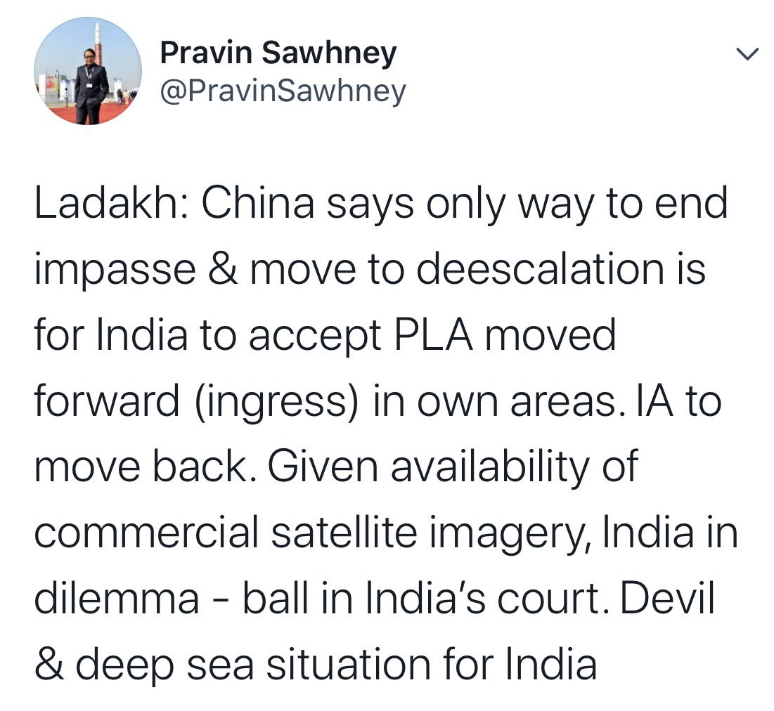
As per The Hindu, China not clarified LAC in Ladakh sector because -
"China has since rejected this exercise, viewing it as adding another complication to the on-going boundary negotiations"
Or may be, just may be, they don& #39;t want to do this because + https://www.thehindu.com/news/national/what-explains-the-india-china-border-flare-up/article31660378.ece">https://www.thehindu.com/news/nati...
+
ambiguity suits them. They can maximize their claim depending on the situation. Claim more tactically superior territory. Or, they can claim what is held by India and then, in negotiations, agree to give it up for tangible gains.
ambiguity suits them. They can maximize their claim depending on the situation. Claim more tactically superior territory. Or, they can claim what is held by India and then, in negotiations, agree to give it up for tangible gains.
- Shows that we& #39;ve an army chief who& #39;s acutely aware of the Chinese shenanigans.
- Having said that, author says that cutting through Galwan-Murgo axis can provide alternate to Karakoram Highway
- How?
- People don& #39;t consult map before writing such stuff? https://m.hindustantimes.com/india-news/army-chief-naravane-s-2012-prophecy-on-chinese-strategy-rings-true-in-ladakh-sector/story-OsfNk1vmIWOQHHNGHGzHcI_amp.html?__twitter_impression=true">https://m.hindustantimes.com/india-new...
Some points -
(1) In my opinion, all the border mgmt related agreements which we& #39;ve sighed over 30+ years with China, are irrelevant.
(2) Let me explain - China is a revisionist and an expansionist power. It is looking for world domination, starting +
#IndiaChinaBorderTension
(1) In my opinion, all the border mgmt related agreements which we& #39;ve sighed over 30+ years with China, are irrelevant.
(2) Let me explain - China is a revisionist and an expansionist power. It is looking for world domination, starting +
#IndiaChinaBorderTension
+
with dominating Asia. India on the other hand is looking for status quo.
(3) For India, these agreements are stepping stone for final border resolution. For China? These are temporary measures to keep things calm in those regions which are not its priority at present
+
with dominating Asia. India on the other hand is looking for status quo.
(3) For India, these agreements are stepping stone for final border resolution. For China? These are temporary measures to keep things calm in those regions which are not its priority at present
+
+
(4) Chinese make very little concession while getting the other side to yield major ground.
(5) Not only that, China throws tantrums from time-to-time to remind the other side that things are not settled or when it wants to send a message.
(6) By signing various border
+
(4) Chinese make very little concession while getting the other side to yield major ground.
(5) Not only that, China throws tantrums from time-to-time to remind the other side that things are not settled or when it wants to send a message.
(6) By signing various border
+
+
management agreements with India, China could focus on its main rival - USA!
(7) Just map the massive naval build-up which the Chinese have done to secure their sea claims. All this was possible only if its borders with its biggest rival in Asia, India, remained calm.
+
management agreements with India, China could focus on its main rival - USA!
(7) Just map the massive naval build-up which the Chinese have done to secure their sea claims. All this was possible only if its borders with its biggest rival in Asia, India, remained calm.
+
+
(8) True, we also needed this quite period to focus on economy but unlike us, Chinese concentrated on building infrastructure for future.
(9) Chinese know they will settle the boundary dispute at their terms. And hence, they put in infra for a conflict which was to happen
+
(8) True, we also needed this quite period to focus on economy but unlike us, Chinese concentrated on building infrastructure for future.
(9) Chinese know they will settle the boundary dispute at their terms. And hence, they put in infra for a conflict which was to happen
+
+
15-20 years in future.
(10) But what did we do? Well, not much. We& #39;ve instances of our Finance Ministry raising question mark on certain acquisitions saying that Chinese are unlikely to be a threat in future!
(11) But Chinese being Chinese, they couldn& #39;t stop themselves from
+
15-20 years in future.
(10) But what did we do? Well, not much. We& #39;ve instances of our Finance Ministry raising question mark on certain acquisitions saying that Chinese are unlikely to be a threat in future!
(11) But Chinese being Chinese, they couldn& #39;t stop themselves from
+
+
trying to show India its place. So, from 2008 onward, they started needling India and we had some major stand-offs in this decade.
(12) So much so that a lethargic institution like GOI, which generally lacks strategic vision, gave permission to Indian Army for a massive
+
trying to show India its place. So, from 2008 onward, they started needling India and we had some major stand-offs in this decade.
(12) So much so that a lethargic institution like GOI, which generally lacks strategic vision, gave permission to Indian Army for a massive
+
+
increment in numbers.
(13) And Indian Army embarked on its biggest expansion after 1985, adding new formations from Daulat Beg Oldi to Arunachal Pradesh.
(14) Even today, as India and China square-off in eastern Ladakh, Chinese are sending three messages.
+
increment in numbers.
(13) And Indian Army embarked on its biggest expansion after 1985, adding new formations from Daulat Beg Oldi to Arunachal Pradesh.
(14) Even today, as India and China square-off in eastern Ladakh, Chinese are sending three messages.
+
(15) Message 01 - that border is not settled and that Chinese can play spoil-sport as they want. I genuinely believe Chinese are not looking for a fight - they& #39;re looking for concessions.
(15.1) I think they will ask India to stop its infra and troop build-up. Why?
+
(15.1) I think they will ask India to stop its infra and troop build-up. Why?
+
(15.2) Simply because even today Chinese are not ready to take-on India. For all their funky weapons and Sun-Tzu inspired fancy quotes, they lack the ratios required to defeat India. Period.
(15.3) With US breathing down their neck, and they now getting push-back in the Pacific
+
(15.3) With US breathing down their neck, and they now getting push-back in the Pacific
+
+
last thing they need is to take-on India.
(15.4) They need another 10 years minimum to take-on India, after having settled their Pacific question.
(15.5) So, they need peace on the Indian border and they need India to remain weak with respect to Infra and troops.
+
last thing they need is to take-on India.
(15.4) They need another 10 years minimum to take-on India, after having settled their Pacific question.
(15.5) So, they need peace on the Indian border and they need India to remain weak with respect to Infra and troops.
+
+
(16) Message 02 - This is quite straight forward - Chinese are facing hostility across the globe for how they& #39;ve conducted themselves with respect to #COVID__19. Plus, they& #39;ve a blow-hot, blow-cold relationship with US. In this situation, they don& #39;t want India to ally
+
(16) Message 02 - This is quite straight forward - Chinese are facing hostility across the globe for how they& #39;ve conducted themselves with respect to #COVID__19. Plus, they& #39;ve a blow-hot, blow-cold relationship with US. In this situation, they don& #39;t want India to ally
+
+
against them.
- Indian Government allowing participation, even though online, of two of its lady parliamentarians, in the swearing-in ceremony of Taiwanese PM, is a big break from the past.
- GOI really really wanted to send across a very strong signal to the Chinese.
+
against them.
- Indian Government allowing participation, even though online, of two of its lady parliamentarians, in the swearing-in ceremony of Taiwanese PM, is a big break from the past.
- GOI really really wanted to send across a very strong signal to the Chinese.
+
+
And the signal is very clear, two can play the game! Anything to do with Taiwan is a big red-line with the Chinese, so this act would& #39;ve been seen a big red-flag by them.
- Rather than talk, the Han is using coercion to get India to fall in line.
- So much for Sun Tzu quotes!
+
And the signal is very clear, two can play the game! Anything to do with Taiwan is a big red-line with the Chinese, so this act would& #39;ve been seen a big red-flag by them.
- Rather than talk, the Han is using coercion to get India to fall in line.
- So much for Sun Tzu quotes!
+
(17) Message 03 - After being surprised in Doklam, Chinese had to send a message that they can get better of India in border dispute.
- This is separate from all out war.
- This is putting the other side in a such a situation where he& #39;s left with little to no maneuvering space
+
- This is separate from all out war.
- This is putting the other side in a such a situation where he& #39;s left with little to no maneuvering space
+
+
and has to agree to a reconciliation at other party& #39;s terms.
- This is what happened to the Chinese in Doklam. Their only option was to escalate full blow conflict or back-down.
- And they did back-down.
- Here again, Chinese would be expecting India to back-down and accept
+
and has to agree to a reconciliation at other party& #39;s terms.
- This is what happened to the Chinese in Doklam. Their only option was to escalate full blow conflict or back-down.
- And they did back-down.
- Here again, Chinese would be expecting India to back-down and accept
+
+
fait-accompli.
- And as mentioned in Message 01, get some concessions also in the bargain.
- Don& #39;t be surprised if Chinese ask for a mechanism to regulate future infra development along the border.
- With themselves having developed their infra, guess who is at disadvantage
+
fait-accompli.
- And as mentioned in Message 01, get some concessions also in the bargain.
- Don& #39;t be surprised if Chinese ask for a mechanism to regulate future infra development along the border.
- With themselves having developed their infra, guess who is at disadvantage
+
+
here?
- Yup! India.
- They can always play tantrum and raise objections at any of our project, claiming it violates the & #39;spirit& #39; of some XYZ agreement.
------------------------
All said and done, we& #39;ve in for a long haul here.
here?
- Yup! India.
- They can always play tantrum and raise objections at any of our project, claiming it violates the & #39;spirit& #39; of some XYZ agreement.
------------------------
All said and done, we& #39;ve in for a long haul here.
And one final, but very critical point:
- Chinese looses face if is not seen to have explicitly won here while India wins by simply standing its ground.
- If India is willing to go the whole hog here, Chinese are going to have a very nasty surprise.
- Simply because while the
+
- Chinese looses face if is not seen to have explicitly won here while India wins by simply standing its ground.
- If India is willing to go the whole hog here, Chinese are going to have a very nasty surprise.
- Simply because while the
+
+
Chinese have mobilized troops to match our immediate strength, but these are not sufficient for a shooting match.
- For that, Chinese need a much much larger mobilization.
- We& #39;re much better placed on this aspect.
- Chinese could get a quick drubbing here.
-----
Wait & Watch!
Chinese have mobilized troops to match our immediate strength, but these are not sufficient for a shooting match.
- For that, Chinese need a much much larger mobilization.
- We& #39;re much better placed on this aspect.
- Chinese could get a quick drubbing here.
-----
Wait & Watch!
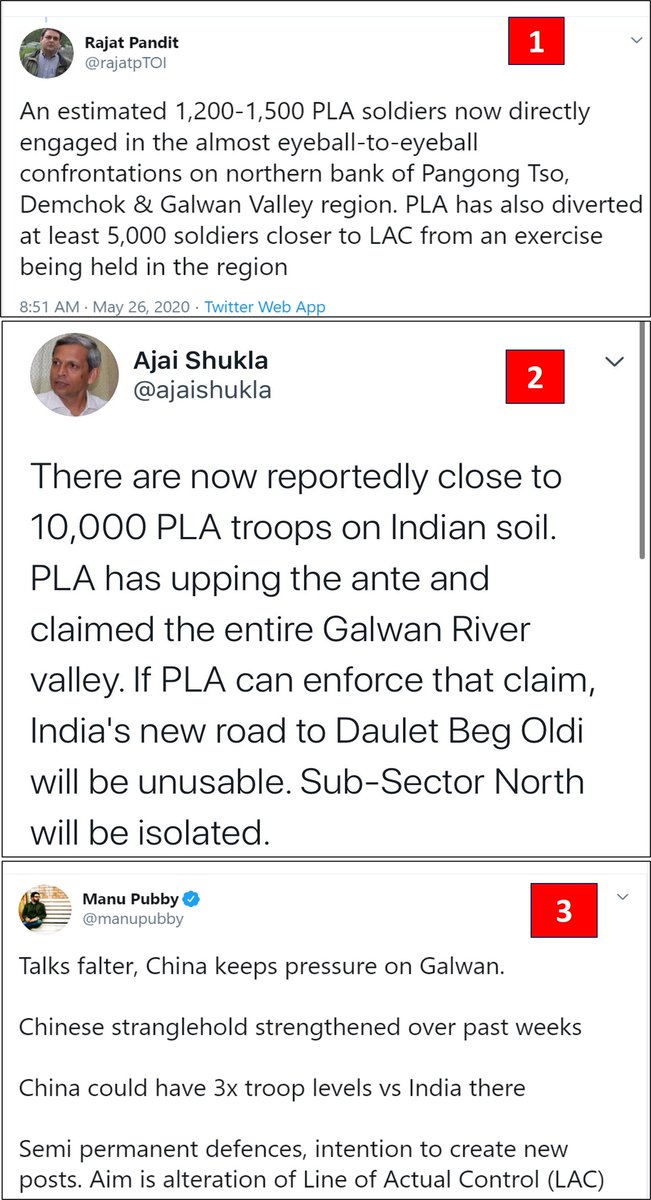
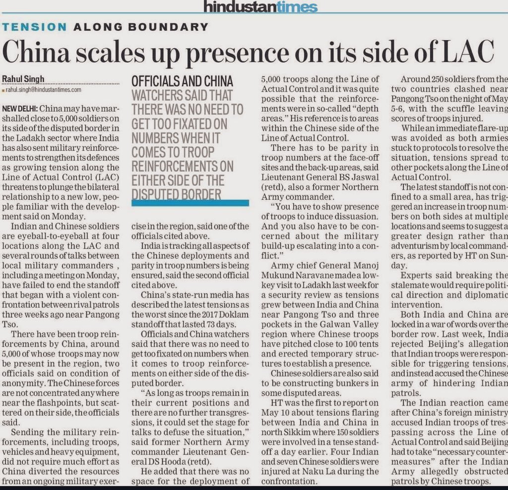
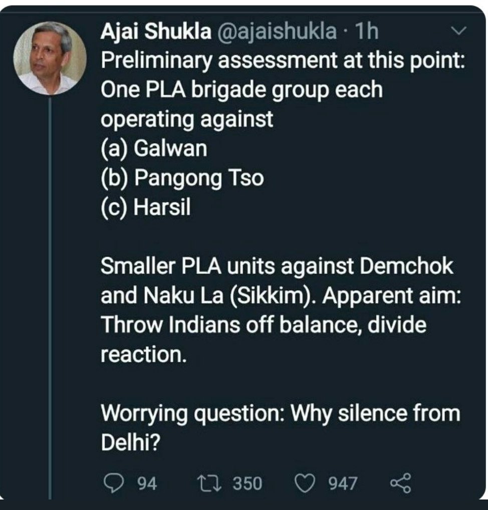
Please look at these 3-data points from three different outlets, all talking about the same incident. Now ask yourself, which is most likely scenario, who& #39;s being alarmist or peddling agenda.
@elmihiro @hukum2082 @Aryanwarlord @YusufDFI @ramana_brf @CestMoiz @desertfox61I
@elmihiro @hukum2082 @Aryanwarlord @YusufDFI @ramana_brf @CestMoiz @desertfox61I
China has marshaled 5,000 troops most of which are on their side
- Finally, some sane commentary.
- Otherwise, some geniuses would have you believe that 10,000 Chinese troops are sitting inside INDIAN territory!
PS: Indian Army has >5 times this number always based in Ladakh.
- Finally, some sane commentary.
- Otherwise, some geniuses would have you believe that 10,000 Chinese troops are sitting inside INDIAN territory!
PS: Indian Army has >5 times this number always based in Ladakh.
A decent article by @jomalhotra on the ongoing India-China stand-off in Eastern Ladakh.
BUT
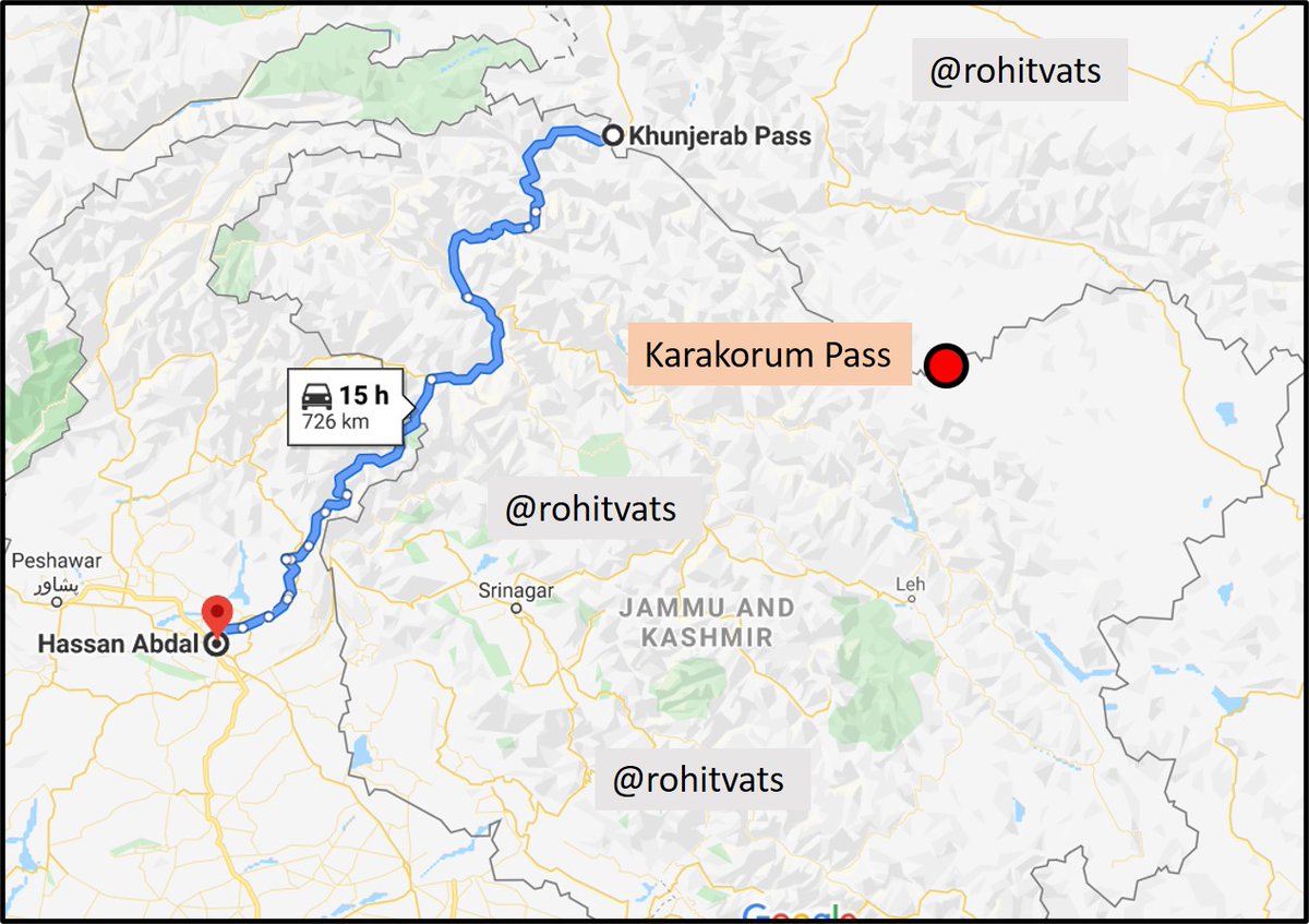
- Please understand, Karakorum Pass on India-China border has NOTHING to do with Karakorum Highway between Pakistan and China.
- See the attached map.
https://theprint.in/opinion/global-print/ladakh-doklam-china-learn-deal-with-assertive-indian-soldier-lac/429349/?utm_source=TPWeb&utm_medium=Telegram&utm_campaign=TappChannel">https://theprint.in/opinion/g...
Karakorum Highway (blue line on the map in previous tweet) is named after the mountain range along with the Kunjerab Pass is located. Karakorum Pass (KK Pass) is also located along the same Karakorum Range but is >250 km east of Kunjerab pass, as the crow flies.
After wild assumptions, some clarity:
- No transgressions in the Galwan Valley
- ~3 km into Indian territory in the larger Hot Spring Area (Patrol Point 14, 15 and Gogra Post) and Fingers Area of Pangong Lake.
- 600-800 Chinese soldiers near each point https://theprint.in/defence/india-wants-lac-status-quo-maintained-china-demands-india-should-stop-construction-activity/429424/">https://theprint.in/defence/i...
And here& #39;s the way immediate way forward. What exactly were the Hans expecting? https://twitter.com/AshutoshGhazal/status/1265213414940516353?s=20">https://twitter.com/AshutoshG...
As the good general sahab says, don& #39;t go by the empty sensational claims of some & #39;journalist& #39; - Do read key points which he mentions: https://twitter.com/ANI/status/1265536541662871553?s=20">https://twitter.com/ANI/statu...
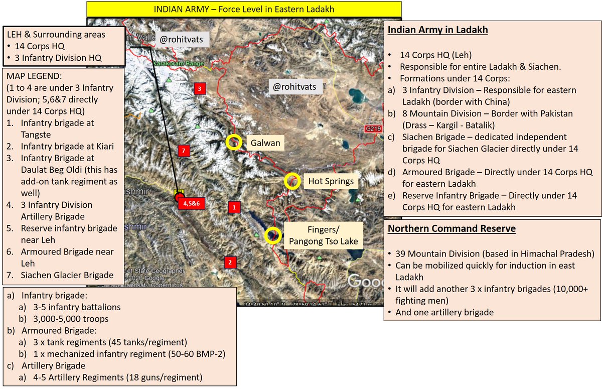
When we have such information being thrown about, its about time to discuss what Indian Army has in the Ladakh theater. Check the next tweet.
-Summary of Indian Army in Eastern Ladakh.
- 150+ tanks, 100+ BMP-2, 20,000+ troops, Artillery guns
- For brigades mentioned on the map, their attendant infantry battalions will be deployed up-front.
- All flash points covered.
- Additional reserves available at short-notice
- 150+ tanks, 100+ BMP-2, 20,000+ troops, Artillery guns
- For brigades mentioned on the map, their attendant infantry battalions will be deployed up-front.
- All flash points covered.
- Additional reserves available at short-notice
"India firm, won’t step back from areas where Chinese troops have intruded"
- India makes its position clear.
- Openly names the Chinese.
- Basically, telling the Chinese that you& #39;ve miscalculated big time.
Read more at: http://timesofindia.indiatimes.com/articleshow/76016584.cms?utm_source=contentofinterest&utm_medium=text&utm_campaign=cppst">https://timesofindia.indiatimes.com/articlesh...
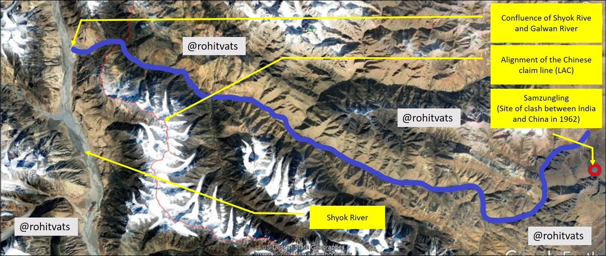
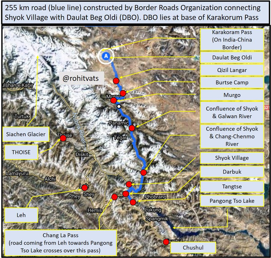
Some relevant maps which I had made earlier, when this stand-off had just been reported:
- Map 1: Important landmarks and area of current face-off (Galwan River)
- Map 2: Galwan River (blue line) along with alignment of Line of Actual Control (as per Google Earth) in the region.
- Map 1: Important landmarks and area of current face-off (Galwan River)
- Map 2: Galwan River (blue line) along with alignment of Line of Actual Control (as per Google Earth) in the region.
- Alignment of Darbuk - Daulat Beg Oldi (DBO) road which is causing pain to the Chinese.
- This 255 km road greatly improves our connectivity with DBO and allows movement of men and material.
- This 255 km road greatly improves our connectivity with DBO and allows movement of men and material.
An example of Chinese Army (People& #39;s Liberation Army-PLA) outpost in the area behind LAC. https://twitter.com/KesariDhwaj/status/1262993830447419393?s=20">https://twitter.com/KesariDhw...
Some third party confirmation of the ground situation along the recent flash-points. But since this does not confirm to & #39;invasion& #39; theory peddled by some, it is likely to be considered as biased. https://twitter.com/Cold_Peace_/status/1266402675807191043?s=20">https://twitter.com/Cold_Peac...
https://twitter.com/Cold_Peace_/status/1266402935342354435?s=20">https://twitter.com/Cold_Peac...
Whats the big deal about PLA deploying artillery guns or tanks or APCs now behind LAC? We& #39;ve had these assets in Ladakh all this while. It only shows that PLA did not initially come prepared and is only now counter-mobilizing after Indian Army moved it assets forward.
NM initially tried to extend olive branch to Pakistanis. And reversed course only after repeated terrorist attacks by it. I think we& #39;re going to witness same here with China. This is a water-shed event. Expect a more hard-line stand against China.
#LadakhBorder #LadakhTension
#LadakhBorder #LadakhTension
Recent video of Indian Army (+ITBP?) soldiers giving some tough love to the Chinese has busted the myth and narrative of meek Indian soldiers & response to aggresive tactics of the Chinese.
We not only have to deal with the Chinese and their belligerent press but our own self proclaimed strategic experts as well.
(pic courtesy: @elmihiro )
(pic courtesy: @elmihiro )
[Galwan River Valley]
- Series of videos courtesy @scorp18th which shows Indian-Chinese patrol engaging each other.
- This appears like the Galwan river valley; Chinese are coming from east, we& #39;re moving from west to east.
- Please focus on the terrain. https://twitter.com/i/status/1267124768639197185">https://twitter.com/i/status/...
[Galwan River Valley]
(1) Look how steep the mountains are on each side, these are near vertical cliffs.
(2) There valley is very narrow; with water flowing in the middle, there is hardly any space on either side for troop movement. https://twitter.com/i/status/1267124895449784321">https://twitter.com/i/status/...
(1) Look how steep the mountains are on each side, these are near vertical cliffs.
(2) There valley is very narrow; with water flowing in the middle, there is hardly any space on either side for troop movement. https://twitter.com/i/status/1267124895449784321">https://twitter.com/i/status/...
(3) Notice the terrain. Loose large stones & gravel.
(4) Please ask yourself this - how could have 000& #39;s of Chinese troops come down this route, as some journalist want you to believe?
(5) And mind you, this part of Galwan River (see map in next tweet) https://twitter.com/i/status/1267124991239340034">https://twitter.com/i/status/...
(4) Please ask yourself this - how could have 000& #39;s of Chinese troops come down this route, as some journalist want you to believe?
(5) And mind you, this part of Galwan River (see map in next tweet) https://twitter.com/i/status/1267124991239340034">https://twitter.com/i/status/...
(6) is actually the widest.
(7) MAP -
- Galwan River valley is very narrow on the Chinese side. And it is like this for entire 40 km length through which Chinese have to come to reach this point.
- Can 000s of troops come down, and be sustained through this route?
(7) MAP -
- Galwan River valley is very narrow on the Chinese side. And it is like this for entire 40 km length through which Chinese have to come to reach this point.
- Can 000s of troops come down, and be sustained through this route?
An important observation - this is plausible because while moving up the Galwan river valley, Chinese troops would& #39;ve had to cross the narrow stream to go from one bank to another searching for a suitable route. Again - 000s of troops through this route? https://twitter.com/30de2e4d6c4f416/status/1267178316827635713?s=20">https://twitter.com/30de2e4d6...
It seems with each passing day, Shook-Law is becoming more desperate. When no one bought his bogus story of 10,000 PLA soldiers having intruded inside India, he& #39;s back with mini-Kargil conspiracy theory. I will present counter-points to sensational claims raised by him.
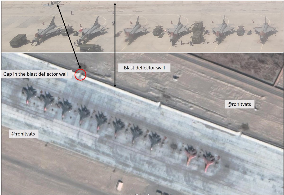
- Images show PLA Air Force concentration in some air base under Western Theater Command.
- Looking at the second pic with 6 J-8 and comparing it with satellite images, my opinion is that this is Hotan Air Base, ~380 km NE from Leh.
https://twitter.com/RupprechtDeino/status/1267788987198058499?s=20">https://twitter.com/Rupprecht...
- Looking at the second pic with 6 J-8 and comparing it with satellite images, my opinion is that this is Hotan Air Base, ~380 km NE from Leh.
https://twitter.com/RupprechtDeino/status/1267788987198058499?s=20">https://twitter.com/Rupprecht...
- Indian Army has moved in troops worth two divisions into eastern Ladakh sector.
- I have said this before, we have more than enough resources to outmatch the Chinese.
- And if Chumar 2014 incident is any template, we aim to dominate in 2:1/3:1 ratio. https://theprint.in/defence/northern-commander-in-ladakh-army-moves-more-troops-amid-standoff-with-china/433774/">https://theprint.in/defence/n...
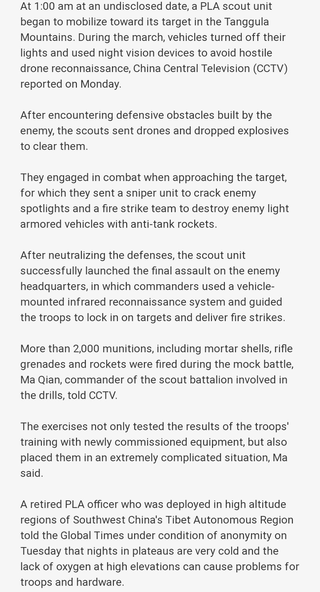
Came across this funny scenario courtesy @VinodDX9 . Lets look at the absurdities here -
(1) Turned off vehicle lights to prevent detection by hostile drones - OK. This has to be the most funniest bit. Lights were switched-off but engines were running! Those vehicles would +
(1) Turned off vehicle lights to prevent detection by hostile drones - OK. This has to be the most funniest bit. Lights were switched-off but engines were running! Those vehicles would +
+
light-up like a Christmas tree on Infra-Red camera of an UAV like in the image below.
- So, surprise is lost!
- & #39;Enemy& #39; will be firing at it even before it can reach anywhere near them.
(2) Using drones to drop explosives to tackle enemy defensive obstacles - Provided this +
light-up like a Christmas tree on Infra-Red camera of an UAV like in the image below.
- So, surprise is lost!
- & #39;Enemy& #39; will be firing at it even before it can reach anywhere near them.
(2) Using drones to drop explosives to tackle enemy defensive obstacles - Provided this +
+
genius PLA scouts unit is not obliterated before hand and some do reach perimeter of & #39;enemy& #39; defensive position, how many drones can you launch and exactly what kind of defensive obstacles can they neutralize?
- Never mind that you& #39;ve already given away surprise and & #39;enemy& #39; +
+ is waiting for you.
- (3) Sniper/enemy search-light? - An enemy who potentially has UAV to search the area, will use search-light to illuminate its defenses? It won& #39;t have IR sensors or battlefield surveillance radars?
- this whole exercise is like a bad Hollywood movie!
- (3) Sniper/enemy search-light? - An enemy who potentially has UAV to search the area, will use search-light to illuminate its defenses? It won& #39;t have IR sensors or battlefield surveillance radars?
- this whole exercise is like a bad Hollywood movie!
Offered without comment - https://twitter.com/PIBFactCheck/status/1267866492298645505?s=20">https://twitter.com/PIBFactCh...
What RM said (from: @DevirupaM )
- & #39;...seema par iss samay Cheen ke log bhi hai& #39;..
[There are Chinese soldiers AT the border. Not WITHIN Indian borders or claim line]
-& #39;..aur acchi khasi sankhya mein Cheen ke log bhi aa gaye hain& #39;.
[There are considerable no of Chinese troops]
- & #39;...seema par iss samay Cheen ke log bhi hai& #39;..
[There are Chinese soldiers AT the border. Not WITHIN Indian borders or claim line]
-& #39;..aur acchi khasi sankhya mein Cheen ke log bhi aa gaye hain& #39;.
[There are considerable no of Chinese troops]
Everything you wanted to know about the Pangong Tso/Fingers Area. @nitingokhale in conversation with @sdinny14 (Colonel S Dinny - he commanded an infantry battalion in this very area). This conversation will clear all your doubts. Do watch and share. https://twitter.com/StratNewsGlobal/status/1267826251298828297?s=20">https://twitter.com/StratNews...
[1962 War History and Current Situation]
- Historical context to alignment of Chinese claim line in Pangong Tso region. And why Indian LAC claim in Fingers Area is different.
- Key is Sirijap Complex: Chinese advanced till Sirijap and captured Indian positions there in 1962
+
- Historical context to alignment of Chinese claim line in Pangong Tso region. And why Indian LAC claim in Fingers Area is different.
- Key is Sirijap Complex: Chinese advanced till Sirijap and captured Indian positions there in 1962
+
+
- Therefore, it is logical to assume that LAC should run along Finger 8 because Chinese forces stood to its east in 1962.
- By advancing LAC till F4, Chinese want to give more depth to their position in Sirijap complex.
- Alignment of Chinese claim line from Rejang La to
+
- Therefore, it is logical to assume that LAC should run along Finger 8 because Chinese forces stood to its east in 1962.
- By advancing LAC till F4, Chinese want to give more depth to their position in Sirijap complex.
- Alignment of Chinese claim line from Rejang La to
+
+
Ane La is in such a fashion that Chinese control all the mountain passes and mountain ridges to ensure India cannot (or, it is very difficult to) attack from west to east.
- (Fingers have been numbered as per map shared by @sdinny14 during his conversation with @nitingokhale.
Ane La is in such a fashion that Chinese control all the mountain passes and mountain ridges to ensure India cannot (or, it is very difficult to) attack from west to east.
- (Fingers have been numbered as per map shared by @sdinny14 during his conversation with @nitingokhale.
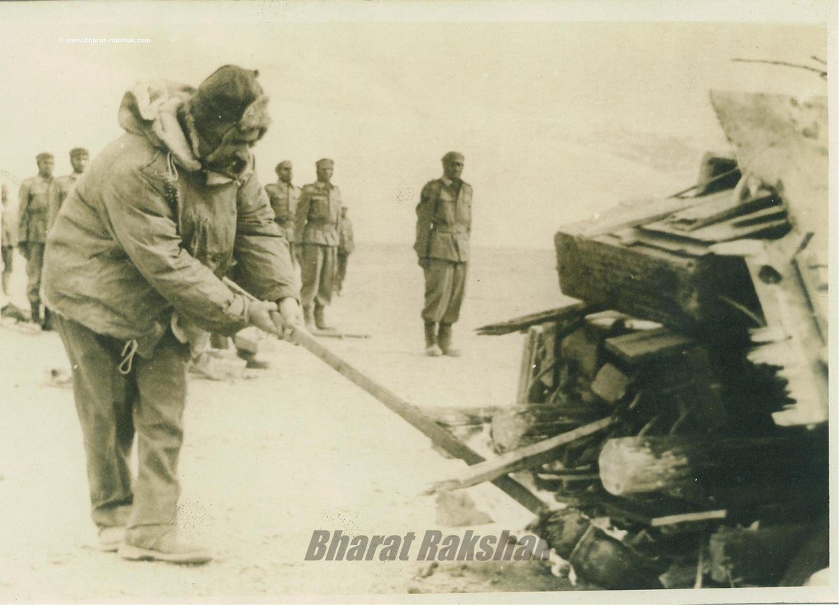
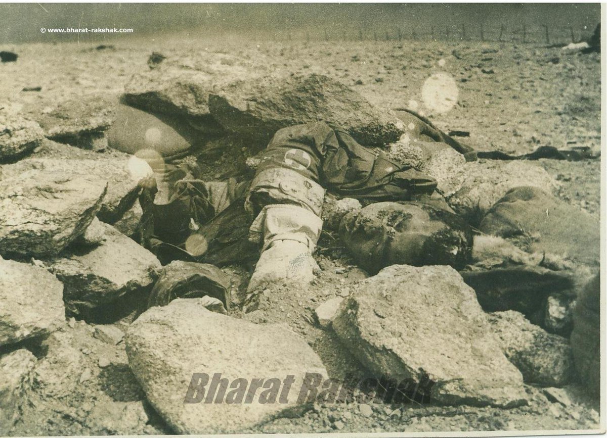
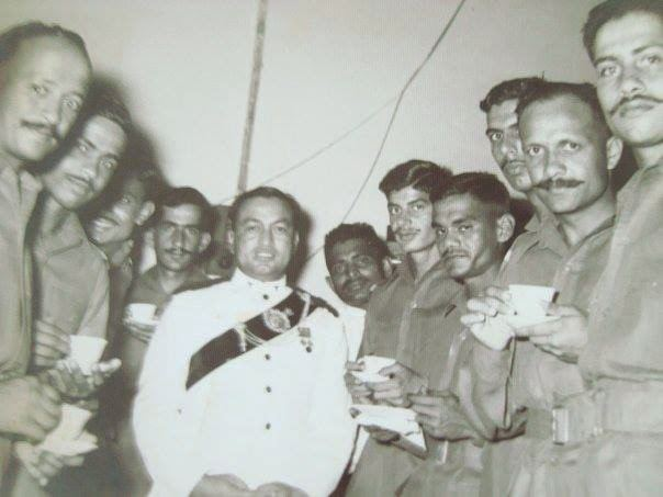
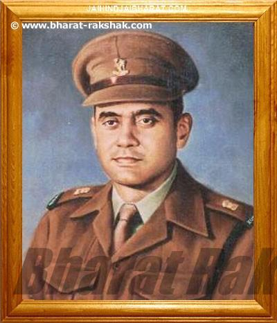
Historical images -
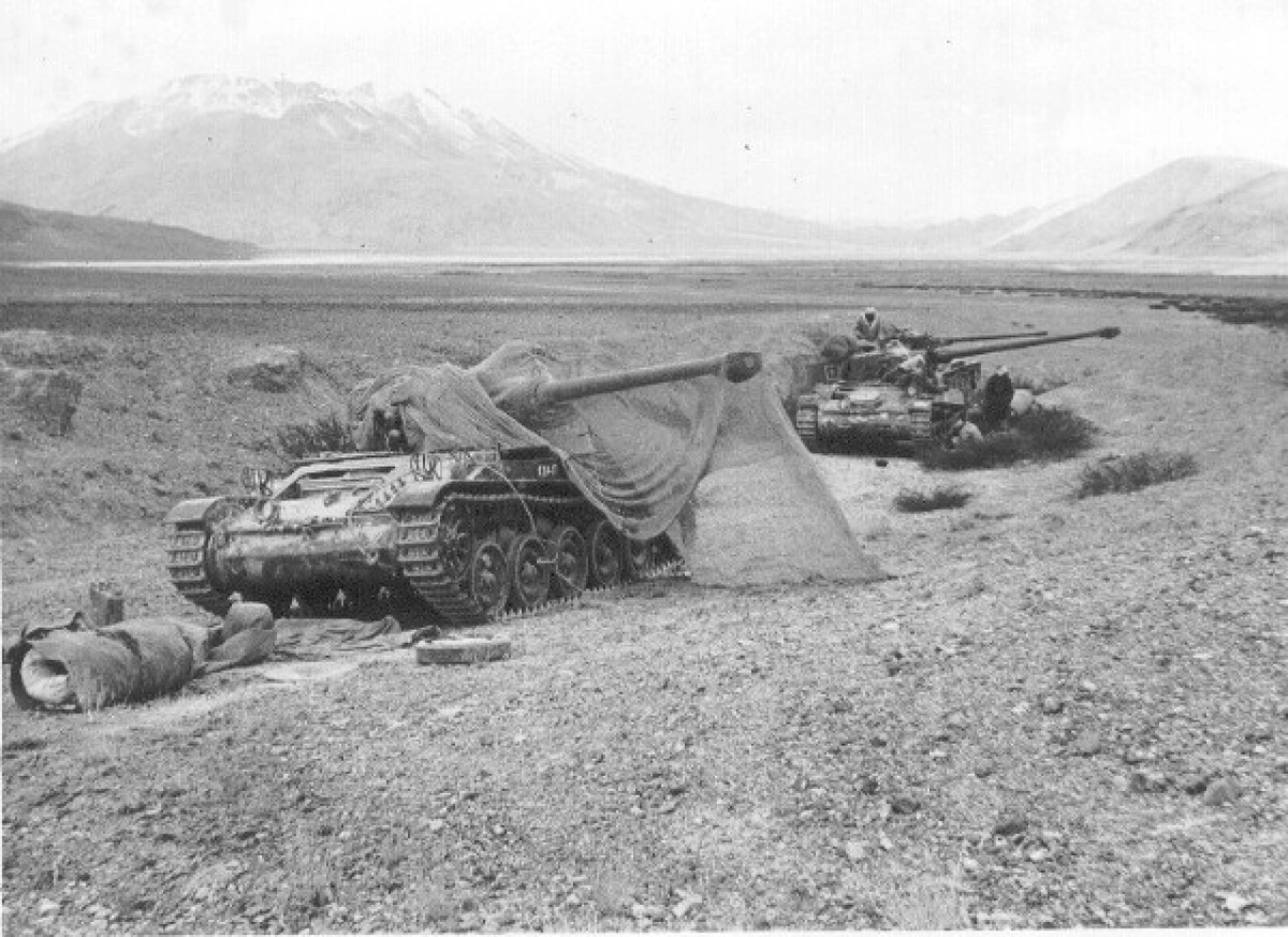
1) AMX-13 tanks, 20 Lancers, defense of Spanngur Gap.
2) Brig TN Raina, MVC, Commander 114 Infantry Brigade lighting the mass funeral pyre
3) Maj Dhan Singh Thapa, PVC
4) Body of Nursing Assistant Dharam Pal Singh Dhaiya who died nursing wounded at Rezang La
1) AMX-13 tanks, 20 Lancers, defense of Spanngur Gap.
2) Brig TN Raina, MVC, Commander 114 Infantry Brigade lighting the mass funeral pyre
3) Maj Dhan Singh Thapa, PVC
4) Body of Nursing Assistant Dharam Pal Singh Dhaiya who died nursing wounded at Rezang La
1) Two Jawans who fought side by side and died side by side at Rezang La
2) Funeral pyre of the jawans from battle of Rezang La
3) Maj Shaitan Singh, PVC (posthumous)
4) Rezang La battle memorial
2) Funeral pyre of the jawans from battle of Rezang La
3) Maj Shaitan Singh, PVC (posthumous)
4) Rezang La battle memorial
Update on the recent developments and status along Pangong Tso and Galwan flash-points. Please read the whole thread. https://twitter.com/nitingokhale/status/1268173251009789954?s=20">https://twitter.com/nitingokh...
Interview of General VP Malik @Vedmalik1 on the India China stand-off in Eastern Ladakh. Do read. https://twitter.com/reportersujan/status/1268743707844423681?s=20">https://twitter.com/reporters...
Detailed discussion on the Galwan River Valley flash-point by @nitingokhale . Please do watch - https://www.youtube.com/watch?v=QNQwqMjHeRA">https://www.youtube.com/watch...
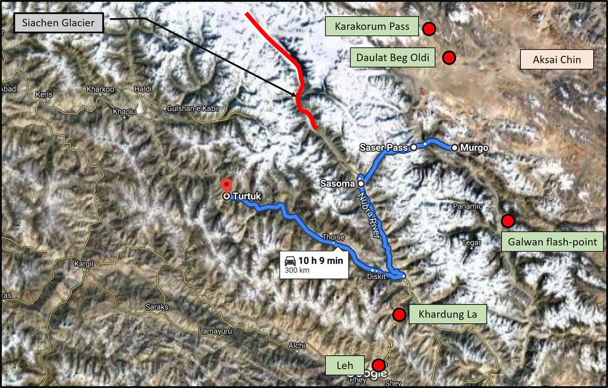
"If the Chinese are able to cut us off at Daulat Beg Oldie, they can put pressure through axis Murgo-Saser La-Sansoma".
-That& #39;s an idiotic statement!
-Check the map for alignment being talked about.
-I explain in follow-on tweets why this is nonsense
+
https://www.hindustantimes.com/india-news/ahead-of-talks-with-china-over-ladakh-standoff-india-signals-a-realistic-approach/story-yhfSaZk0vucG6f1vPKZHrK.html">https://www.hindustantimes.com/india-new...
+
- For China to connect with Pakistan through this axis would mean going west from Murgo, crossing Shyok River, crossing the 17,752 feet high Saser La pass, and then going down towards Sasoma (which is ~50 Km from Siachen Base Camp)
- Then it has to reach Diskit near confluence+
- For China to connect with Pakistan through this axis would mean going west from Murgo, crossing Shyok River, crossing the 17,752 feet high Saser La pass, and then going down towards Sasoma (which is ~50 Km from Siachen Base Camp)
- Then it has to reach Diskit near confluence+
+
of Nubra and Shyok River.
- From there, it goes west to THOISE and then along the Shyok River, reaches Turtuk (last point in India along LOC in this sector).
- If anything like this were to happen, it would mean we& #39;ve lost Siachen Glacier and the entire Nubra and Shyok Valley
+
of Nubra and Shyok River.
- From there, it goes west to THOISE and then along the Shyok River, reaches Turtuk (last point in India along LOC in this sector).
- If anything like this were to happen, it would mean we& #39;ve lost Siachen Glacier and the entire Nubra and Shyok Valley
+
+
including THOISE and all villages along the river as it flows into Pakistan.
- If it ever comes to this situation, it would mean India has been defeated at such a scale that 1962 will appear benign!
- Oh! and BTW, Border Road Organization (BRO) is actually working on creating
+
including THOISE and all villages along the river as it flows into Pakistan.
- If it ever comes to this situation, it would mean India has been defeated at such a scale that 1962 will appear benign!
- Oh! and BTW, Border Road Organization (BRO) is actually working on creating
+
+
- a road going from Sasoma towards Saser La Pass and thence, going down the other side of the mountain, reaching Shyok River, crossing from west to east bank and then, reaching Murgo.
-From Murgo, route goes to DBO and Karakorum Pass.
- As of 2016-17, BRO had constructed
+
- a road going from Sasoma towards Saser La Pass and thence, going down the other side of the mountain, reaching Shyok River, crossing from west to east bank and then, reaching Murgo.
-From Murgo, route goes to DBO and Karakorum Pass.
- As of 2016-17, BRO had constructed
+
+
a 52 km road from Sasoma to Saser La road.
- Road from the pass towards Murgo is WIP.
- When this road is ready, India will have an alternate route to new Shyok-DBO Road.
- Always good to have alternates in a shooting match!
- Here is some bit of history for you -
+
a 52 km road from Sasoma to Saser La road.
- Road from the pass towards Murgo is WIP.
- When this road is ready, India will have an alternate route to new Shyok-DBO Road.
- Always good to have alternates in a shooting match!
- Here is some bit of history for you -
+
+
-- Summer route for caravans traveling from Leh to Yarkand in Xinjiang was Leh->Khardung La Pass ->Sasoma->Saser La->Murgo->DBO-> Karakorum Pass.
-- Winter Route: Leh -> Chang La pass - > Shyok Village->move on/along frozen Shyok River-Murgo->DBO->Karakorum Pass.
-- Summer route for caravans traveling from Leh to Yarkand in Xinjiang was Leh->Khardung La Pass ->Sasoma->Saser La->Murgo->DBO-> Karakorum Pass.
-- Winter Route: Leh -> Chang La pass - > Shyok Village->move on/along frozen Shyok River-Murgo->DBO->Karakorum Pass.
[Bursting Chinese Propaganda]
- Typical Chinese propaganda of super efficient Chinese soldiers and PLA!
- Tragedy is, many buy into such propaganda as well.
- Time to burst this bubble:
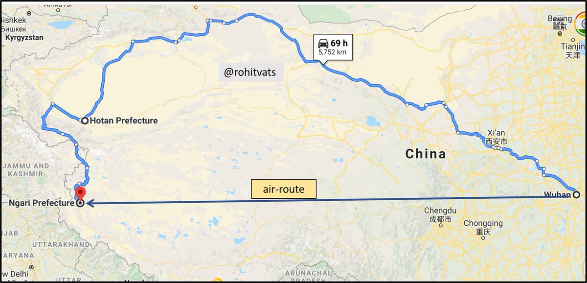
(1) Chinese 15 Airborne Corps is based in northern part of their+ https://twitter.com/globaltimesnews/status/1269567756287897601?s=20">https://twitter.com/globaltim...
+
Hubei province whose capital is Wuhan!
(2) From Hubei, troops and mechanized assets have to move to an area opposite Aksai China.
(3) Air distance - ~3,200 km (Ngari Airport) / Road & distance - ~5,800 km (assuming road & rail distance is same)
- Please see the map below.
Hubei province whose capital is Wuhan!
(2) From Hubei, troops and mechanized assets have to move to an area opposite Aksai China.
(3) Air distance - ~3,200 km (Ngari Airport) / Road & distance - ~5,800 km (assuming road & rail distance is same)
- Please see the map below.
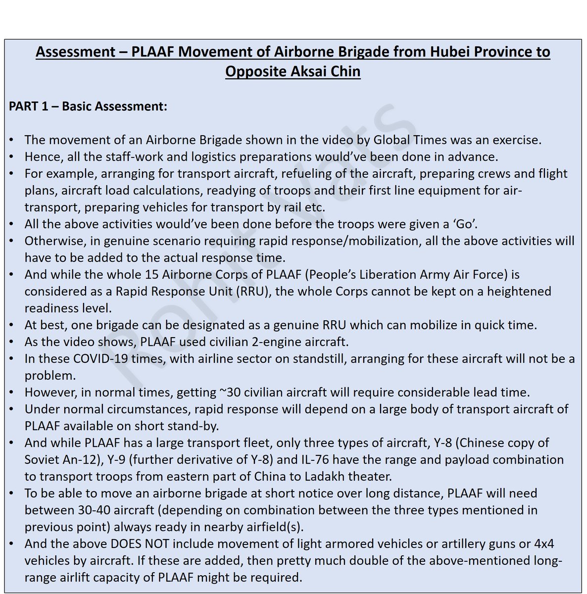
PART 1 - Basic Assessment.
(1) Chinese are passing off a normal military exercise, planned in advance, involving one of their airborne brigade(s), as some sort of rapid response to current stand-off.
- See Part-1 of detailed assessment below:
(1) Chinese are passing off a normal military exercise, planned in advance, involving one of their airborne brigade(s), as some sort of rapid response to current stand-off.
- See Part-1 of detailed assessment below:
Part 2 - Assumptions taken for analysis.
- Basic assumptions taken to analyse the troop movement as mentioned in Global Times.
- But does China have airport capacity near Ladakh to handle these troops? Please check follow-on tweet(s).
+
- Basic assumptions taken to analyse the troop movement as mentioned in Global Times.
- But does China have airport capacity near Ladakh to handle these troops? Please check follow-on tweet(s).
+
Part 3+4: Travel time required by air, rail and road.
- By air: 11-12 hrs to reach Ngari airport (70% troops)
- Rail (Wuhan to Hotan) - 4 days [30% troops plus IFV, light tanks & vehicles]
- Road (Hotan to Ngari): 2.5 days. [ Hotan is last railway node] [ Total: 6.5 days]
- By air: 11-12 hrs to reach Ngari airport (70% troops)
- Rail (Wuhan to Hotan) - 4 days [30% troops plus IFV, light tanks & vehicles]
- Road (Hotan to Ngari): 2.5 days. [ Hotan is last railway node] [ Total: 6.5 days]
Part 5 - Ngari Airport - Bottleneck!
- It has ONE runway of 10,000+ feet length.
- Entrance to parking area is in middle of the runway length.
- On landing, a transport a/c will have to travel till opposite end, turn around, travel back half distance and then, enter parking area.
- It has ONE runway of 10,000+ feet length.
- Entrance to parking area is in middle of the runway length.
- On landing, a transport a/c will have to travel till opposite end, turn around, travel back half distance and then, enter parking area.
Parking Space:
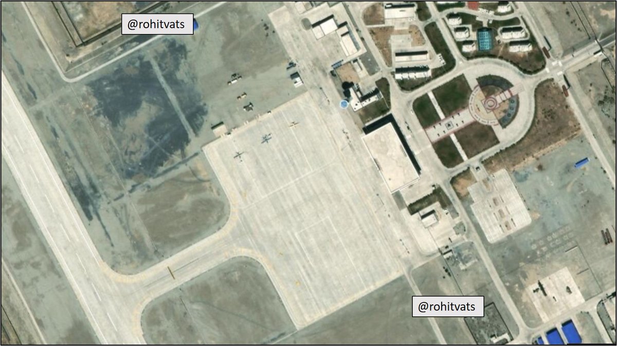
- Satellite image (Sep 2019) below shows 3 x UAV parked on northern side of the apron.
- This side can at best accommodate 4 x A-320 size a/c.
- Similarly, assume 4 a/c on opposite side.
- Prima facie, the airport can at a time hold at max 8 A-320 sized passenger
+
- Satellite image (Sep 2019) below shows 3 x UAV parked on northern side of the apron.
- This side can at best accommodate 4 x A-320 size a/c.
- Similarly, assume 4 a/c on opposite side.
- Prima facie, the airport can at a time hold at max 8 A-320 sized passenger
+
+
aircraft (of the type in which Chinese troops are seen traveling in the Global Times video).
- But as our calculation shows, PLAAF will need about 20 a/c minimum to transport 70% of airborne brigade troops by air.
- Coupled with additional time required for an a/c to enter +
aircraft (of the type in which Chinese troops are seen traveling in the Global Times video).
- But as our calculation shows, PLAAF will need about 20 a/c minimum to transport 70% of airborne brigade troops by air.
- Coupled with additional time required for an a/c to enter +
+
parking space/apron (because of single runway as explained earlier) and limited parking space within apron itself, the balance 12 a/c will have to spend considerable time in the air till first wave of 8 a/c are able to off-load their troops+cargo, turn-around, go to start of
+
parking space/apron (because of single runway as explained earlier) and limited parking space within apron itself, the balance 12 a/c will have to spend considerable time in the air till first wave of 8 a/c are able to off-load their troops+cargo, turn-around, go to start of
+
+
runway and then take-off.
- This will have to be a sequential process as there is only one runway with added handicap of apron entrance being in the middle.
- All this will add time to transport the airborne brigade.
- To the 11-12 hours required from & #39;GO& #39; to reach airspace
+
runway and then take-off.
- This will have to be a sequential process as there is only one runway with added handicap of apron entrance being in the middle.
- All this will add time to transport the airborne brigade.
- To the 11-12 hours required from & #39;GO& #39; to reach airspace
+
+
above this airport, you can easily add couple of more hours.
- Other options is for the airborne troops to land at Hotan airport. It has the required infra to host 20 a/c transporting the airborne brigade.
- BUT - if troops land at this airport, they will need ~ 2 days
+
above this airport, you can easily add couple of more hours.
- Other options is for the airborne troops to land at Hotan airport. It has the required infra to host 20 a/c transporting the airborne brigade.
- BUT - if troops land at this airport, they will need ~ 2 days
+
+
to reach operational area opposite Aksai Chin.
- Long story short, there is NO way in which the Chinese/PLAAF can transport a full airborne brigade, with its compliments of infantry fighting vehicles, light tanks and other assets in a & #39;matter of hour& #39; opposite Aksai Chin.
END
to reach operational area opposite Aksai Chin.
- Long story short, there is NO way in which the Chinese/PLAAF can transport a full airborne brigade, with its compliments of infantry fighting vehicles, light tanks and other assets in a & #39;matter of hour& #39; opposite Aksai Chin.
END
Just to add one critical point to the above analysis-
(1) Elevation above sea level (Wuhan area) - ~100 feet
(2) Avg Ladakh elevation - 14,000 feet.
- Time required for acclimatization to effectively work and operate and fight at this altitude - 3 WEEKS!
(1) Elevation above sea level (Wuhan area) - ~100 feet
(2) Avg Ladakh elevation - 14,000 feet.
- Time required for acclimatization to effectively work and operate and fight at this altitude - 3 WEEKS!
Very interesting observation - Chinese soldiers traveling by chair car on a 4+ days of train journey  https://abs.twimg.com/emoji/v2/... draggable="false" alt="😆" title="Lächelndes Gesicht mit geöffnetem Mund und fest verschlossenen Augen" aria-label="Emoji: Lächelndes Gesicht mit geöffnetem Mund und fest verschlossenen Augen">....this whole propaganda is going from bad to worse. https://twitter.com/a_sandhan/status/1269861912637960194?s=20">https://twitter.com/a_sandhan...
Shots fired... Government making its intentions known to the general public. Not to mention the Chinese will take notice. I guess the same message, given in a more softer manner by Rajnath Singh has not been registered. https://twitter.com/PTI_News/status/1269960181061804032?s=20">https://twitter.com/PTI_News/...
Indian Para Special Forces under-taking free-fall jump from a C-130 Hercules aircraft, somewhere over Ladakh. https://twitter.com/delhidefence/status/1270215696195244032?s=20">https://twitter.com/delhidefe...

 Read on Twitter



![What RM said (from: @DevirupaM )- & #39;...seema par iss samay Cheen ke log bhi hai& #39;..[There are Chinese soldiers AT the border. Not WITHIN Indian borders or claim line]-& #39;..aur acchi khasi sankhya mein Cheen ke log bhi aa gaye hain& #39;.[There are considerable no of Chinese troops] What RM said (from: @DevirupaM )- & #39;...seema par iss samay Cheen ke log bhi hai& #39;..[There are Chinese soldiers AT the border. Not WITHIN Indian borders or claim line]-& #39;..aur acchi khasi sankhya mein Cheen ke log bhi aa gaye hain& #39;.[There are considerable no of Chinese troops]](https://pbs.twimg.com/media/EZkihLnVAAAWrFs.png)
![[1962 War History and Current Situation]- Historical context to alignment of Chinese claim line in Pangong Tso region. And why Indian LAC claim in Fingers Area is different.- Key is Sirijap Complex: Chinese advanced till Sirijap and captured Indian positions there in 1962+ [1962 War History and Current Situation]- Historical context to alignment of Chinese claim line in Pangong Tso region. And why Indian LAC claim in Fingers Area is different.- Key is Sirijap Complex: Chinese advanced till Sirijap and captured Indian positions there in 1962+](https://pbs.twimg.com/media/EZqCVuLVAAEujOy.jpg)
![[1962 War History and Current Situation]- Historical context to alignment of Chinese claim line in Pangong Tso region. And why Indian LAC claim in Fingers Area is different.- Key is Sirijap Complex: Chinese advanced till Sirijap and captured Indian positions there in 1962+ [1962 War History and Current Situation]- Historical context to alignment of Chinese claim line in Pangong Tso region. And why Indian LAC claim in Fingers Area is different.- Key is Sirijap Complex: Chinese advanced till Sirijap and captured Indian positions there in 1962+](https://pbs.twimg.com/media/EZqCVunU4AAqwgF.jpg)




![Part 3+4: Travel time required by air, rail and road.- By air: 11-12 hrs to reach Ngari airport (70% troops)- Rail (Wuhan to Hotan) - 4 days [30% troops plus IFV, light tanks & vehicles] - Road (Hotan to Ngari): 2.5 days. [ Hotan is last railway node] [ Total: 6.5 days] Part 3+4: Travel time required by air, rail and road.- By air: 11-12 hrs to reach Ngari airport (70% troops)- Rail (Wuhan to Hotan) - 4 days [30% troops plus IFV, light tanks & vehicles] - Road (Hotan to Ngari): 2.5 days. [ Hotan is last railway node] [ Total: 6.5 days]](https://pbs.twimg.com/media/EZ7g-5MUwAEyUZU.jpg)
![Part 3+4: Travel time required by air, rail and road.- By air: 11-12 hrs to reach Ngari airport (70% troops)- Rail (Wuhan to Hotan) - 4 days [30% troops plus IFV, light tanks & vehicles] - Road (Hotan to Ngari): 2.5 days. [ Hotan is last railway node] [ Total: 6.5 days] Part 3+4: Travel time required by air, rail and road.- By air: 11-12 hrs to reach Ngari airport (70% troops)- Rail (Wuhan to Hotan) - 4 days [30% troops plus IFV, light tanks & vehicles] - Road (Hotan to Ngari): 2.5 days. [ Hotan is last railway node] [ Total: 6.5 days]](https://pbs.twimg.com/media/EZ7hA66UwAEHKCf.jpg)
![Part 3+4: Travel time required by air, rail and road.- By air: 11-12 hrs to reach Ngari airport (70% troops)- Rail (Wuhan to Hotan) - 4 days [30% troops plus IFV, light tanks & vehicles] - Road (Hotan to Ngari): 2.5 days. [ Hotan is last railway node] [ Total: 6.5 days] Part 3+4: Travel time required by air, rail and road.- By air: 11-12 hrs to reach Ngari airport (70% troops)- Rail (Wuhan to Hotan) - 4 days [30% troops plus IFV, light tanks & vehicles] - Road (Hotan to Ngari): 2.5 days. [ Hotan is last railway node] [ Total: 6.5 days]](https://pbs.twimg.com/media/EZ7hCWDUMAAYQfw.jpg)

