How hilly is Cork City?
The topography of Cork City was mentioned as a reason why it is difficult to improve the cycling infrastructure in the city: https://www.echolive.ie/corknews/Whingers-make-me-sick-Former-Lord-Mayor-hits-out-at-City-Hall-critics-09d807d4-3a36-482b-af78-90da52eb3b8a-ds#.XrwkZqIg6mI.twitter
So,">https://www.echolive.ie/corknews/... I did some spatial analysis to find out how hilly Cork actually is.
THREAD https://abs.twimg.com/emoji/v2/... draggable="false" alt="👇" title="Down pointing backhand index" aria-label="Emoji: Down pointing backhand index">
1/13
#cycling #cork
The topography of Cork City was mentioned as a reason why it is difficult to improve the cycling infrastructure in the city: https://www.echolive.ie/corknews/Whingers-make-me-sick-Former-Lord-Mayor-hits-out-at-City-Hall-critics-09d807d4-3a36-482b-af78-90da52eb3b8a-ds#.XrwkZqIg6mI.twitter
So,">https://www.echolive.ie/corknews/... I did some spatial analysis to find out how hilly Cork actually is.
THREAD
1/13
#cycling #cork
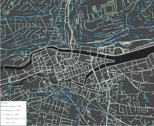
The map below shows the gradient of the roads in Cork City.
There are some steep roads (dark blue) north of the Lee, and south of the N40, however, the central east-west corridor is quite flat (light green).
You can see a live version of the map at http://www.cyclingreporter.org/hills
2/13">https://www.cyclingreporter.org/hills&quo...
There are some steep roads (dark blue) north of the Lee, and south of the N40, however, the central east-west corridor is quite flat (light green).
You can see a live version of the map at http://www.cyclingreporter.org/hills
2/13">https://www.cyclingreporter.org/hills&quo...
Not really an unexpected result so far.
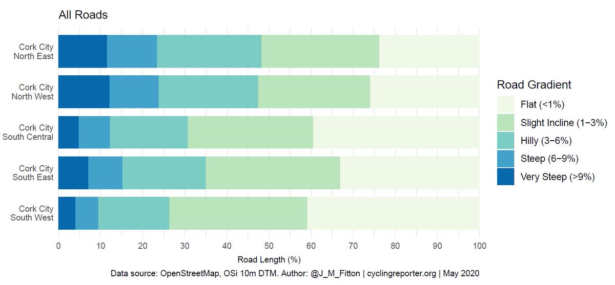
However, if you calculate the statistics for each LEA, they show that for ALL roads in Cork City, the majority are classified as either Flat (< 1% gradient) or a Slight Incline (1-3% slope) across all LEAs.
3/13
However, if you calculate the statistics for each LEA, they show that for ALL roads in Cork City, the majority are classified as either Flat (< 1% gradient) or a Slight Incline (1-3% slope) across all LEAs.
3/13
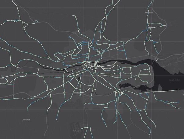
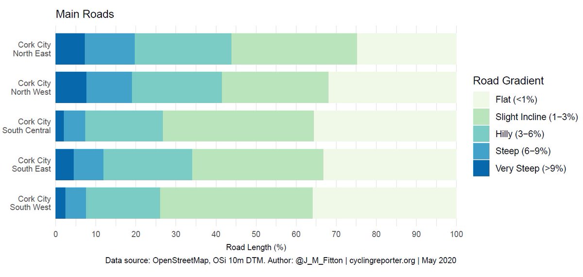
If we limit the analysis to just the MAIN roads (primary, secondary, or, tertiary in the OpenStreetMap dataset), again, the majority of the roads in Cork City are classed as either Flat (< 1% gradient) or a Slight Incline (1-3% slope) across all LEAs.
4/13
4/13
To put the gradients into context, these are the average gradients of some selected hills:
Falcon Hill: 17.5%
Mahony& #39;s Avenue: 17%
St. Patrick& #39;s Hill: 14%
Matthew Hill: 7%
Barrack Street: 6%
Summer Hill North: 6%
Maryborough Hill: 5%
5/13
Falcon Hill: 17.5%
Mahony& #39;s Avenue: 17%
St. Patrick& #39;s Hill: 14%
Matthew Hill: 7%
Barrack Street: 6%
Summer Hill North: 6%
Maryborough Hill: 5%
5/13
For further context, this article describes the cycling effort required for different hill gradients:
https://tickettoridegroup.com/blog/laymans-guide-cycling-gradients/?q=laymans-guide-cycling-gradients/&q=laymans-guide-cycling-gradients/
6/13">https://tickettoridegroup.com/blog/laym...
https://tickettoridegroup.com/blog/laymans-guide-cycling-gradients/?q=laymans-guide-cycling-gradients/&q=laymans-guide-cycling-gradients/
6/13">https://tickettoridegroup.com/blog/laym...
What does this mean for cycling infrastructure in Cork?
In my opinion, this analysis shows that a lot of roads in Cork are really not that hilly. The city centre itself is basically flat, and many of the main routes into the city are also <3% gradient.
7/13
In my opinion, this analysis shows that a lot of roads in Cork are really not that hilly. The city centre itself is basically flat, and many of the main routes into the city are also <3% gradient.
7/13
There is certainly a concentration of hilly and steep hills in the north of the city. This is also coupled with a lack of cycling lane/tracks in the area.
But if there was cycling infrastructure – would people cycle up (and down) these hills?
8/13
But if there was cycling infrastructure – would people cycle up (and down) these hills?
8/13
Probably.
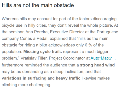
This is article the summaries the issues and solutions in ‘hilly’ cities https://ecf.com/news-and-events/news/cycling-hilly-cities-possible-sure.">https://ecf.com/news-and-...
TL:DR – hills do put some people off, but by far the main issue is a lack of cycling infrastructure.
9/13
This is article the summaries the issues and solutions in ‘hilly’ cities https://ecf.com/news-and-events/news/cycling-hilly-cities-possible-sure.">https://ecf.com/news-and-...
TL:DR – hills do put some people off, but by far the main issue is a lack of cycling infrastructure.
9/13
Furthermore, electric bike sales are expected to rapidly increase globally – 130 million expected to be sold between 2020 and 2023 – which will further reduce the issue of cycling up hills.
10/13
https://www2.deloitte.com/content/dam/insights/us/articles/722835_tmt-predictions-2020/DI_TMT-Prediction-2020.pdf">https://www2.deloitte.com/content/d...
10/13
https://www2.deloitte.com/content/dam/insights/us/articles/722835_tmt-predictions-2020/DI_TMT-Prediction-2020.pdf">https://www2.deloitte.com/content/d...
In conclusion:
This (quick) analysis has shown that the majority of the roads within Cork are easily cyclable. There are some very steep hills north of the city – but well-planned cycling infrastructure (and electric bikes) could encourage people to cycle despite these.
11/13
This (quick) analysis has shown that the majority of the roads within Cork are easily cyclable. There are some very steep hills north of the city – but well-planned cycling infrastructure (and electric bikes) could encourage people to cycle despite these.
11/13
Methods:
The length of road sections was calculated, and the elevation from the start and end of the road section was extracted from a digital elevation model.
The slope is then calculated as (height difference/length) x 100.
Data sources: OpenSteetMap, OSi 10 DEM
12/13
The length of road sections was calculated, and the elevation from the start and end of the road section was extracted from a digital elevation model.
The slope is then calculated as (height difference/length) x 100.
Data sources: OpenSteetMap, OSi 10 DEM
12/13
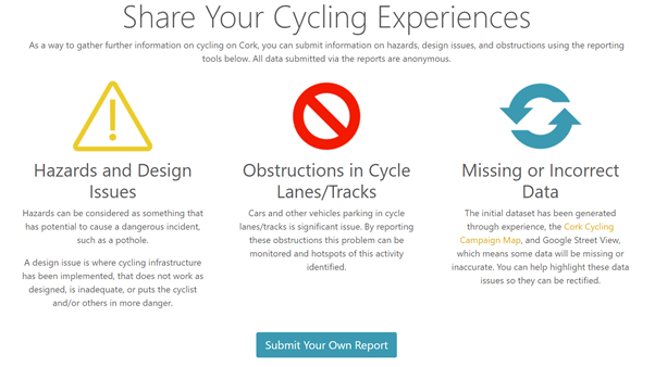
To help improve Cork Cycling Infrastructure, you can contribute to a crowd sourced dataset by reporting hazards and design issues at http://www.cyclingreporter.org"> http://www.cyclingreporter.org #cycling #cork
13/13
13/13
Small Correction:
The comment made about topography was reported in the Irish Examiner article, not the Echo Live. https://www.irishexaminer.com/breakingnews/ireland/fianna-fail-councillor-stop-whinging-over-returning-cork-traffic-999316.html">https://www.irishexaminer.com/breakingn...
The comment made about topography was reported in the Irish Examiner article, not the Echo Live. https://www.irishexaminer.com/breakingnews/ireland/fianna-fail-councillor-stop-whinging-over-returning-cork-traffic-999316.html">https://www.irishexaminer.com/breakingn...

 Read on Twitter