This year, the #LondonMarathon would have been held under clear blue skies. Satellite images show us iconic spots along the route abandoned under #lockdown.
This thread compares Sunday& #39;s cloud-free image with 22 April 2018; the last time the race ran under clear skies [1/5] https://abs.twimg.com/emoji/v2/... draggable="false" alt="🛰️" title="Satellite" aria-label="Emoji: Satellite">
 https://abs.twimg.com/emoji/v2/... draggable="false" alt="🏃" title="Person running" aria-label="Emoji: Person running">
This thread compares Sunday& #39;s cloud-free image with 22 April 2018; the last time the race ran under clear skies [1/5]
The Sentinel-2 satellite @CopernicusEU passes overhead around midday, shortly after the elite runners will have finished  https://abs.twimg.com/emoji/v2/... draggable="false" alt="🛰️" title="Satellite" aria-label="Emoji: Satellite">
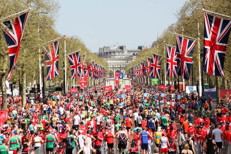
 https://abs.twimg.com/emoji/v2/... draggable="false" alt="🏃" title="Person running" aria-label="Emoji: Person running"> Here we can see the Mall in 2018, bustling with media tents, red banners, a mass of people after the finishing line, and a busy Thames [2/5]
At the time of the  https://abs.twimg.com/emoji/v2/... draggable="false" alt="🛰️" title="Satellite" aria-label="Emoji: Satellite">overpass, many runners will have been crossing Tower Bridge at ~12 miles. Even with this high-resolution imagery (each pixel is 10 m across), it& #39;s not possible to make out individual people. Compared with 2018, you can see the clearer streets yesterday [3/5]
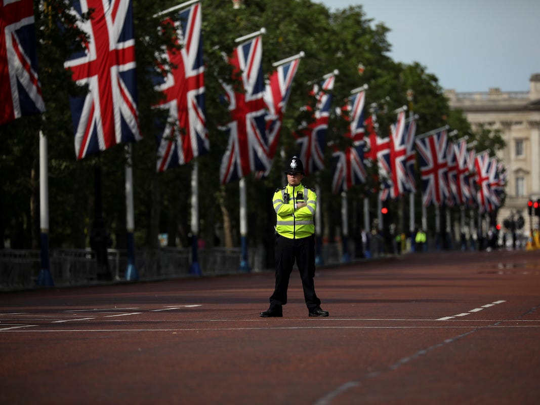
And here are some close-ups of the finishing line on the Mall next to Buckingham Palace, and the Tower of London, where you can clearly see the difference between empty streets yesterday and those filled with runners in 2018. [4/5]
Explore the route for yourself using @sentinel_hub:
22 April 2018 marathon day https://abs.twimg.com/emoji/v2/... draggable="false" alt="🏃" title="Person running" aria-label="Emoji: Person running">
 https://abs.twimg.com/emoji/v2/... draggable="false" alt="🛰️" title="Satellite" aria-label="Emoji: Satellite">: https://apps.sentinel-hub.com/eo-browser/?lat=51.49929&lng=-0.09845&zoom=13&time=2018-04-22&preset=1_TRUE_COLOR&datasource=Sentinel-2%20L2A
26">https://apps.sentinel-hub.com/eo-browse... April 2020 marathon day https://abs.twimg.com/emoji/v2/... draggable="false" alt="🔒" title="Lock" aria-label="Emoji: Lock">
 https://abs.twimg.com/emoji/v2/... draggable="false" alt="🏠" title="House building" aria-label="Emoji: House building">: https://apps.sentinel-hub.com/eo-browser/?lat=51.49929&lng=-0.09845&zoom=13&time=2020-04-26&preset=1_TRUE_COLOR&datasource=Sentinel-2%20L2A
https://apps.sentinel-hub.com/eo-browse... href="https://twtext.com//hashtag/LondonMarathon"> #LondonMarathon #londonlockdown Data from @CopernicusEU @ESA_EO with post-processing by @DrTELS [5/5]
22 April 2018 marathon day
26">https://apps.sentinel-hub.com/eo-browse... April 2020 marathon day
This thread was inspired by @Sentinel_hub& #39;s COVID-19 Custom Script Contest @EuroDataCube. I didn& #39;t develop a script, but it did get me thinking about how you might be able to see the impact of COVID-19 from space. If you& #39;re interested in the contest: https://www.sentinel-hub.com/contest ">https://www.sentinel-hub.com/contest&q...

 Read on Twitter
![Satellite This year, the #LondonMarathon would have been held under clear blue skies. Satellite images show us iconic spots along the route abandoned under #lockdown.This thread compares Sunday& #39;s cloud-free image with 22 April 2018; the last time the race ran under clear skies [1/5] https://abs.twimg.com/emoji/v2/... draggable=](https://pbs.twimg.com/media/EWjyKjzXgAk-Xcp.jpg) https://abs.twimg.com/emoji/v2/... draggable="false" alt="🏃" title="Person running" aria-label="Emoji: Person running">" title="This year, the #LondonMarathon would have been held under clear blue skies. Satellite images show us iconic spots along the route abandoned under #lockdown.This thread compares Sunday& #39;s cloud-free image with 22 April 2018; the last time the race ran under clear skies [1/5] https://abs.twimg.com/emoji/v2/... draggable="false" alt="🛰️" title="Satellite" aria-label="Emoji: Satellite">https://abs.twimg.com/emoji/v2/... draggable="false" alt="🏃" title="Person running" aria-label="Emoji: Person running">">
https://abs.twimg.com/emoji/v2/... draggable="false" alt="🏃" title="Person running" aria-label="Emoji: Person running">" title="This year, the #LondonMarathon would have been held under clear blue skies. Satellite images show us iconic spots along the route abandoned under #lockdown.This thread compares Sunday& #39;s cloud-free image with 22 April 2018; the last time the race ran under clear skies [1/5] https://abs.twimg.com/emoji/v2/... draggable="false" alt="🛰️" title="Satellite" aria-label="Emoji: Satellite">https://abs.twimg.com/emoji/v2/... draggable="false" alt="🏃" title="Person running" aria-label="Emoji: Person running">">
![Satellite This year, the #LondonMarathon would have been held under clear blue skies. Satellite images show us iconic spots along the route abandoned under #lockdown.This thread compares Sunday& #39;s cloud-free image with 22 April 2018; the last time the race ran under clear skies [1/5] https://abs.twimg.com/emoji/v2/... draggable=](https://pbs.twimg.com/media/EWjyM1WXkAcA2eT.jpg) https://abs.twimg.com/emoji/v2/... draggable="false" alt="🏃" title="Person running" aria-label="Emoji: Person running">" title="This year, the #LondonMarathon would have been held under clear blue skies. Satellite images show us iconic spots along the route abandoned under #lockdown.This thread compares Sunday& #39;s cloud-free image with 22 April 2018; the last time the race ran under clear skies [1/5] https://abs.twimg.com/emoji/v2/... draggable="false" alt="🛰️" title="Satellite" aria-label="Emoji: Satellite">https://abs.twimg.com/emoji/v2/... draggable="false" alt="🏃" title="Person running" aria-label="Emoji: Person running">">
https://abs.twimg.com/emoji/v2/... draggable="false" alt="🏃" title="Person running" aria-label="Emoji: Person running">" title="This year, the #LondonMarathon would have been held under clear blue skies. Satellite images show us iconic spots along the route abandoned under #lockdown.This thread compares Sunday& #39;s cloud-free image with 22 April 2018; the last time the race ran under clear skies [1/5] https://abs.twimg.com/emoji/v2/... draggable="false" alt="🛰️" title="Satellite" aria-label="Emoji: Satellite">https://abs.twimg.com/emoji/v2/... draggable="false" alt="🏃" title="Person running" aria-label="Emoji: Person running">">
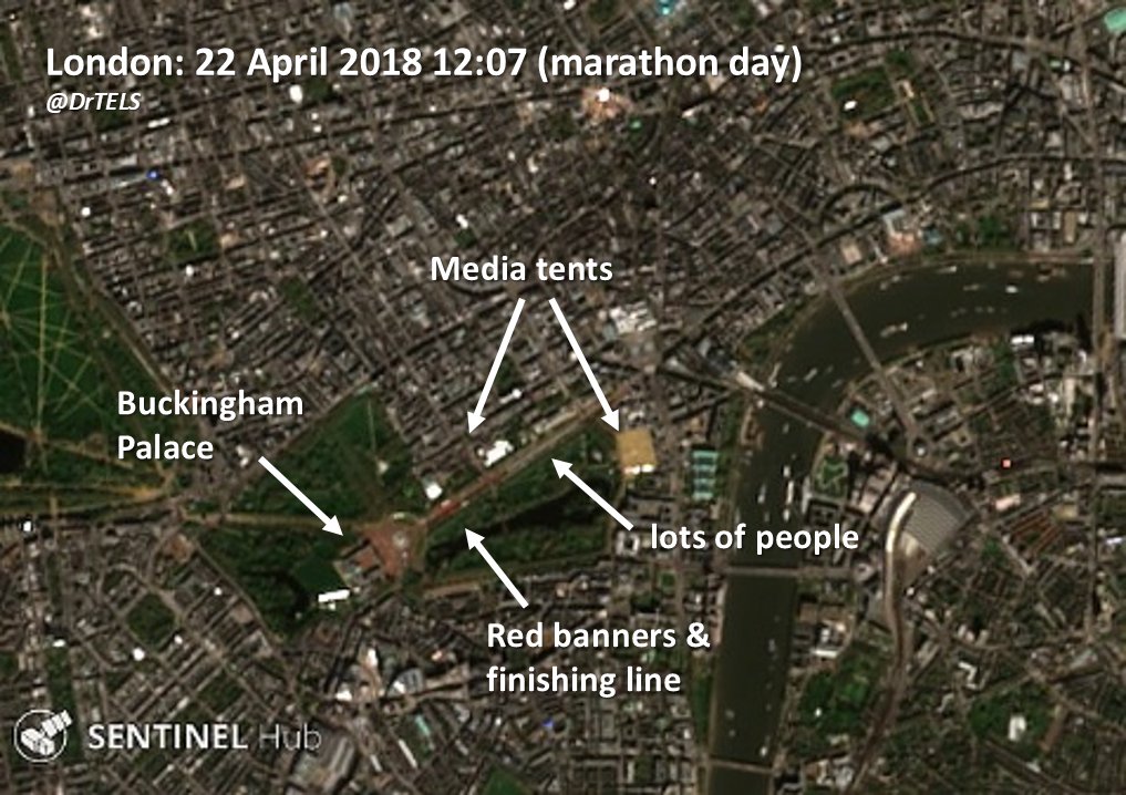 https://abs.twimg.com/emoji/v2/... draggable="false" alt="🏃" title="Person running" aria-label="Emoji: Person running"> Here we can see the Mall in 2018, bustling with media tents, red banners, a mass of people after the finishing line, and a busy Thames [2/5]" title="The Sentinel-2 satellite @CopernicusEU passes overhead around midday, shortly after the elite runners will have finished https://abs.twimg.com/emoji/v2/... draggable="false" alt="🛰️" title="Satellite" aria-label="Emoji: Satellite">https://abs.twimg.com/emoji/v2/... draggable="false" alt="🏃" title="Person running" aria-label="Emoji: Person running"> Here we can see the Mall in 2018, bustling with media tents, red banners, a mass of people after the finishing line, and a busy Thames [2/5]">
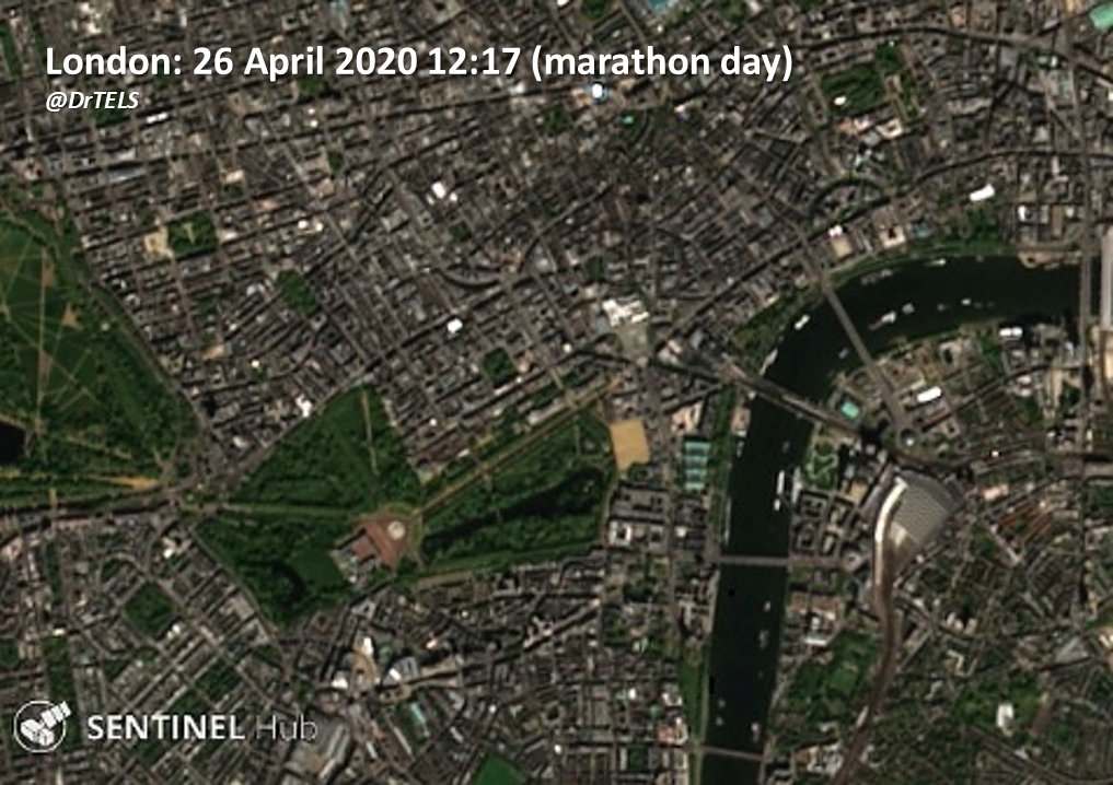 https://abs.twimg.com/emoji/v2/... draggable="false" alt="🏃" title="Person running" aria-label="Emoji: Person running"> Here we can see the Mall in 2018, bustling with media tents, red banners, a mass of people after the finishing line, and a busy Thames [2/5]" title="The Sentinel-2 satellite @CopernicusEU passes overhead around midday, shortly after the elite runners will have finished https://abs.twimg.com/emoji/v2/... draggable="false" alt="🛰️" title="Satellite" aria-label="Emoji: Satellite">https://abs.twimg.com/emoji/v2/... draggable="false" alt="🏃" title="Person running" aria-label="Emoji: Person running"> Here we can see the Mall in 2018, bustling with media tents, red banners, a mass of people after the finishing line, and a busy Thames [2/5]">
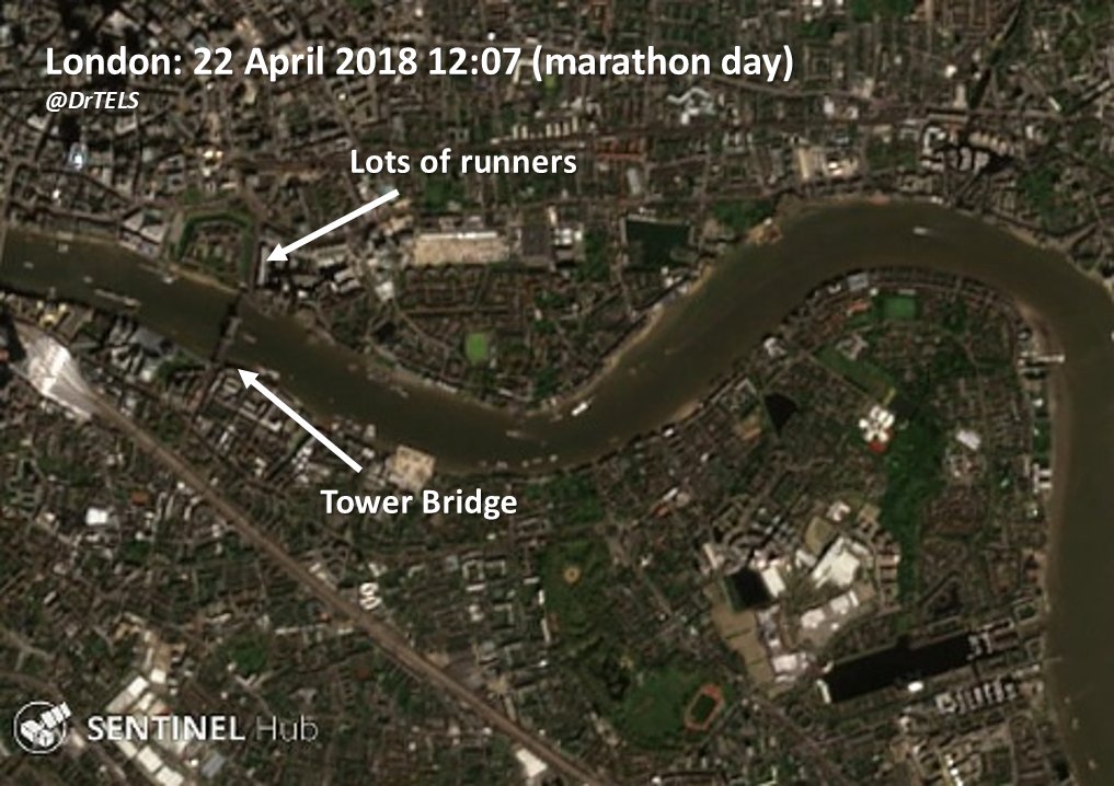 overpass, many runners will have been crossing Tower Bridge at ~12 miles. Even with this high-resolution imagery (each pixel is 10 m across), it& #39;s not possible to make out individual people. Compared with 2018, you can see the clearer streets yesterday [3/5]" title="At the time of the https://abs.twimg.com/emoji/v2/... draggable="false" alt="🛰️" title="Satellite" aria-label="Emoji: Satellite">overpass, many runners will have been crossing Tower Bridge at ~12 miles. Even with this high-resolution imagery (each pixel is 10 m across), it& #39;s not possible to make out individual people. Compared with 2018, you can see the clearer streets yesterday [3/5]">
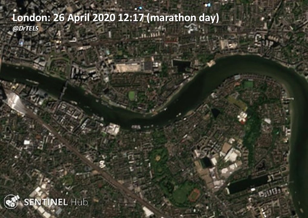 overpass, many runners will have been crossing Tower Bridge at ~12 miles. Even with this high-resolution imagery (each pixel is 10 m across), it& #39;s not possible to make out individual people. Compared with 2018, you can see the clearer streets yesterday [3/5]" title="At the time of the https://abs.twimg.com/emoji/v2/... draggable="false" alt="🛰️" title="Satellite" aria-label="Emoji: Satellite">overpass, many runners will have been crossing Tower Bridge at ~12 miles. Even with this high-resolution imagery (each pixel is 10 m across), it& #39;s not possible to make out individual people. Compared with 2018, you can see the clearer streets yesterday [3/5]">
![And here are some close-ups of the finishing line on the Mall next to Buckingham Palace, and the Tower of London, where you can clearly see the difference between empty streets yesterday and those filled with runners in 2018. [4/5] And here are some close-ups of the finishing line on the Mall next to Buckingham Palace, and the Tower of London, where you can clearly see the difference between empty streets yesterday and those filled with runners in 2018. [4/5]](https://pbs.twimg.com/media/EWjyac4WAAQRviD.jpg)
![And here are some close-ups of the finishing line on the Mall next to Buckingham Palace, and the Tower of London, where you can clearly see the difference between empty streets yesterday and those filled with runners in 2018. [4/5] And here are some close-ups of the finishing line on the Mall next to Buckingham Palace, and the Tower of London, where you can clearly see the difference between empty streets yesterday and those filled with runners in 2018. [4/5]](https://pbs.twimg.com/media/EWjycGVWAAAPtiC.jpg)
![And here are some close-ups of the finishing line on the Mall next to Buckingham Palace, and the Tower of London, where you can clearly see the difference between empty streets yesterday and those filled with runners in 2018. [4/5] And here are some close-ups of the finishing line on the Mall next to Buckingham Palace, and the Tower of London, where you can clearly see the difference between empty streets yesterday and those filled with runners in 2018. [4/5]](https://pbs.twimg.com/media/EWjydkLWAAACfFy.jpg)
![And here are some close-ups of the finishing line on the Mall next to Buckingham Palace, and the Tower of London, where you can clearly see the difference between empty streets yesterday and those filled with runners in 2018. [4/5] And here are some close-ups of the finishing line on the Mall next to Buckingham Palace, and the Tower of London, where you can clearly see the difference between empty streets yesterday and those filled with runners in 2018. [4/5]](https://pbs.twimg.com/media/EWj4ncoWAAIbdvJ.jpg)
 https://abs.twimg.com/emoji/v2/... draggable="false" alt="🛰️" title="Satellite" aria-label="Emoji: Satellite">: https://apps.sentinel-hub.com/eo-browse... April 2020 marathon day https://abs.twimg.com/emoji/v2/... draggable="false" alt="🔒" title="Lock" aria-label="Emoji: Lock">https://abs.twimg.com/emoji/v2/... draggable="false" alt="🏠" title="House building" aria-label="Emoji: House building">: https://apps.sentinel-hub.com/eo-browse... href="https://twtext.com//hashtag/LondonMarathon"> #LondonMarathon #londonlockdown Data from @CopernicusEU @ESA_EO with post-processing by @DrTELS [5/5]" title="Explore the route for yourself using @sentinel_hub:22 April 2018 marathon day https://abs.twimg.com/emoji/v2/... draggable="false" alt="🏃" title="Person running" aria-label="Emoji: Person running">https://abs.twimg.com/emoji/v2/... draggable="false" alt="🛰️" title="Satellite" aria-label="Emoji: Satellite">: https://apps.sentinel-hub.com/eo-browse... April 2020 marathon day https://abs.twimg.com/emoji/v2/... draggable="false" alt="🔒" title="Lock" aria-label="Emoji: Lock">https://abs.twimg.com/emoji/v2/... draggable="false" alt="🏠" title="House building" aria-label="Emoji: House building">: https://apps.sentinel-hub.com/eo-browse... href="https://twtext.com//hashtag/LondonMarathon"> #LondonMarathon #londonlockdown Data from @CopernicusEU @ESA_EO with post-processing by @DrTELS [5/5]">
 https://abs.twimg.com/emoji/v2/... draggable="false" alt="🛰️" title="Satellite" aria-label="Emoji: Satellite">: https://apps.sentinel-hub.com/eo-browse... April 2020 marathon day https://abs.twimg.com/emoji/v2/... draggable="false" alt="🔒" title="Lock" aria-label="Emoji: Lock">https://abs.twimg.com/emoji/v2/... draggable="false" alt="🏠" title="House building" aria-label="Emoji: House building">: https://apps.sentinel-hub.com/eo-browse... href="https://twtext.com//hashtag/LondonMarathon"> #LondonMarathon #londonlockdown Data from @CopernicusEU @ESA_EO with post-processing by @DrTELS [5/5]" title="Explore the route for yourself using @sentinel_hub:22 April 2018 marathon day https://abs.twimg.com/emoji/v2/... draggable="false" alt="🏃" title="Person running" aria-label="Emoji: Person running">https://abs.twimg.com/emoji/v2/... draggable="false" alt="🛰️" title="Satellite" aria-label="Emoji: Satellite">: https://apps.sentinel-hub.com/eo-browse... April 2020 marathon day https://abs.twimg.com/emoji/v2/... draggable="false" alt="🔒" title="Lock" aria-label="Emoji: Lock">https://abs.twimg.com/emoji/v2/... draggable="false" alt="🏠" title="House building" aria-label="Emoji: House building">: https://apps.sentinel-hub.com/eo-browse... href="https://twtext.com//hashtag/LondonMarathon"> #LondonMarathon #londonlockdown Data from @CopernicusEU @ESA_EO with post-processing by @DrTELS [5/5]">


