
 Read on Twitter
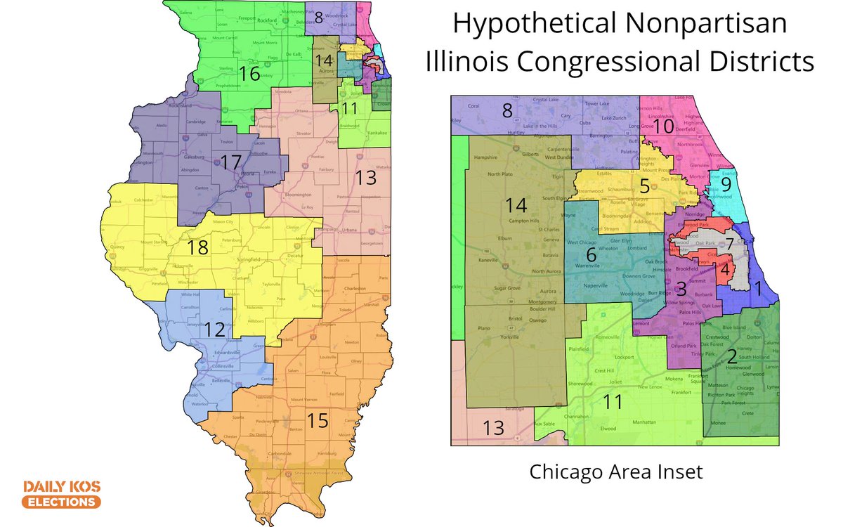
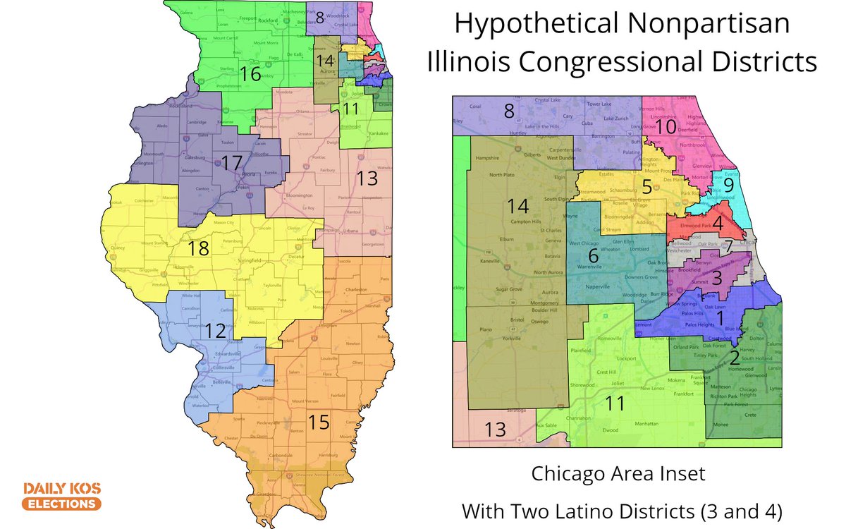
I& #39;ve drawn some new Illinois nonpartisan congressional maps recently & am wondering what folks think, particularly with the Chicago variants I& #39;ll post in this thread. To start, I finished these two maps 3 years ago using 2010 pop. 1st map has one Latino district, 2nd map has two


The new nonpartisan Illinois congressional maps draw downstate differently, making it more compact & easier to keep the 12 Chicago districts entirely within the Chicago metro area (dropping Kankakee). Both maps here have 1 Latino seat #IL04 & differ mainly in how they draw #IL03
. Both maps here have 1 Latino seat #IL04 & differ mainly in how they draw #IL03")
. Both maps here have 1 Latino seat #IL04 & differ mainly in how they draw #IL03")
I prefer 2 Latino districts, & it seems to better reflect communities of interest. But it& #39;s unclear if #IL04 at 47% white, 38% Latino among adult citizens is adequate for Latinos in a Dem primary in a 79-16 Clinton seat. #IL03 is 50% Latino, 35% White in a 74-21 Clinton seat

Here are 3 different versions of #IL04, #IL05, #IL08, & #IL08. It& #39;s unclear where it makes more sense to prioritize keeping townships whole vs. cities, so this was a tricky area. Map 1 is more compact. Map 2 very closely follows socioeconomic lines around #IL10, Map 3 compromises


These maps likely wouldn& #39;t have changed any 2014/2018 election outcomes compared to my original maps. 2016 Dems wouldn& #39;t have won #IL10 under the two maps that don& #39;t split Lake County vertically, but they might& #39;ve won #IL08 in 2012 on those two. All maps likely go 12D-6R in 2018
Here are the Dave& #39;s Redistricting App links to these maps so you can copy them over to your own DRA & redraw them if you have any better suggestions.
1 Latino seat:
https://davesredistricting.org/join/4ea3a9f9-21ab-4805-9ca7-0ef36b2c9f55
https://davesredistricting.org/join/4ea3... href=" https://davesredistricting.org/join/5701202b-6996-439b-949b-6720e9be99bc
2">https://davesredistricting.org/join/5701... Latino seats:
https://davesredistricting.org/join/eb507ec7-354c-4fbf-a764-709641d80c4e">https://davesredistricting.org/join/eb50... https://davesredistricting.org/join/8c473229-6d53-4b80-89b7-0e13e555ed09">https://davesredistricting.org/join/8c47...
1 Latino seat:
https://davesredistricting.org/join/4ea3a9f9-21ab-4805-9ca7-0ef36b2c9f55
2">https://davesredistricting.org/join/5701... Latino seats:
https://davesredistricting.org/join/eb507ec7-354c-4fbf-a764-709641d80c4e">https://davesredistricting.org/join/eb50... https://davesredistricting.org/join/8c473229-6d53-4b80-89b7-0e13e555ed09">https://davesredistricting.org/join/8c47...
Two more hypothetical nonpartisan Illinois congressional maps for this thread. I& #39;m still working on the election result calculations & will post them when done. Dave& #39;s Redistricting App links here (including 2016 pres/Senate):
https://davesredistricting.org/join/eca35bd0-63d8-41ab-9c0c-72f6b7988cca
https://davesredistricting.org/join/eca3... href=" https://davesredistricting.org/join/423d616c-4301-4c0e-a443-f4602f0b3d4b">https://davesredistricting.org/join/423d...
https://davesredistricting.org/join/eca35bd0-63d8-41ab-9c0c-72f6b7988cca
 https://davesredistricting.org/join/423d..." title="Two more hypothetical nonpartisan Illinois congressional maps for this thread. I& #39;m still working on the election result calculations & will post them when done. Dave& #39;s Redistricting App links here (including 2016 pres/Senate): https://davesredistricting.org/join/eca3... href=" https://davesredistricting.org/join/423d616c-4301-4c0e-a443-f4602f0b3d4b">https://davesredistricting.org/join/423d...">
 https://davesredistricting.org/join/423d..." title="Two more hypothetical nonpartisan Illinois congressional maps for this thread. I& #39;m still working on the election result calculations & will post them when done. Dave& #39;s Redistricting App links here (including 2016 pres/Senate): https://davesredistricting.org/join/eca3... href=" https://davesredistricting.org/join/423d616c-4301-4c0e-a443-f4602f0b3d4b">https://davesredistricting.org/join/423d...">


