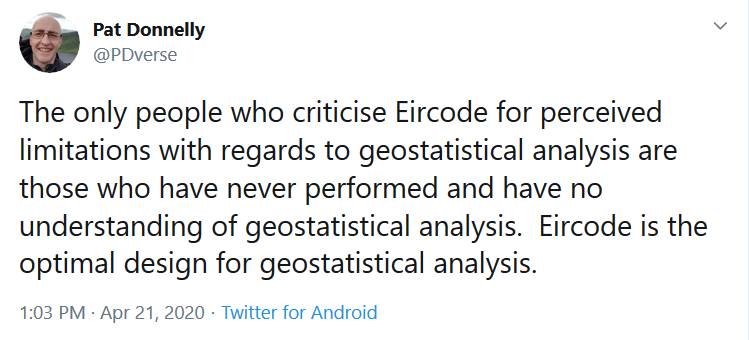
As with all analysis, it is only as good as source data.
As source data, Eircode has a major issue:
It& #39;s primary design purpose is as a postcode for postal delivery & that does not need a high level of geospatial precision as posties deliver by local knowledge & iteration.
As source data, Eircode has a major issue:
It& #39;s primary design purpose is as a postcode for postal delivery & that does not need a high level of geospatial precision as posties deliver by local knowledge & iteration.
of course @pdverse wants to defend the project he was/is involved in but we cannot ignore that as Eircode was designed for POST these data quality issues arise:
1)The attribution of an Eircode to an address & related location has multiple publicly quoted examples of error
2)>
1)The attribution of an Eircode to an address & related location has multiple publicly quoted examples of error
2)>
2)The distribution of Eircode to those addresses has multiple publicly quoted examples of error
3)No QA process has ever been undertaken to assure the quality of attribution and distribution & to quantify or resolve errors systematically & reliably post distribution
4)The random>
3)No QA process has ever been undertaken to assure the quality of attribution and distribution & to quantify or resolve errors systematically & reliably post distribution
4)The random>
4)The random, non hierarchical nature of Eircode does not lend itself to reliable recall, particularly in stressful situations. This nature was specified by An Post as its postal process did not require better.
5)Validation >
5)Validation >
5)Validation of Eircode at a public capture point has several challenges which are routinely avoided, again raising issues about post capture data quality
6)Though the inexperienced may consider Eircode to be the equivalent of x,y or geographic coordinates, it is not for these>
6)Though the inexperienced may consider Eircode to be the equivalent of x,y or geographic coordinates, it is not for these>
these reasons
* the capture of precise geospatial coordinates does not normally require human recall
*Such coordinates are normally captured with devices & process which dictate QA and often by well trained professionals with suitable equipment
*Coordinates can be attributed >
* the capture of precise geospatial coordinates does not normally require human recall
*Such coordinates are normally captured with devices & process which dictate QA and often by well trained professionals with suitable equipment
*Coordinates can be attributed >
to any location even those where previous professional mapping has not taken place. Eircode cannot
*Professionally derived coordinates normally come with a provenance which assures quality for the purpose being used and the precision in which expressed also guides application >
*Professionally derived coordinates normally come with a provenance which assures quality for the purpose being used and the precision in which expressed also guides application >
this is not the case with Eircode.
*Coordinates can themselves be used to define suitable polygons for aggregation & related meaningful analysis - Eircode cannot
7)There are multiple publicly quoted examples of Eircode being used for a purpose not designed and failing
*Coordinates can themselves be used to define suitable polygons for aggregation & related meaningful analysis - Eircode cannot
7)There are multiple publicly quoted examples of Eircode being used for a purpose not designed and failing
8) The use of coordinates does not require a Minister to deem the purpose to which they are applied "appropriate" as is the case with Eircode by Statute
For these reasons, any assertion that Eircode is equivalent in all respects to a precise x,y coordinate & therefore unlimited
For these reasons, any assertion that Eircode is equivalent in all respects to a precise x,y coordinate & therefore unlimited
in capability for geospatial analysis is uninformed opinion.
This twitter treatment is not by any means comprehensive but raises key issues. They& #39;re being raised here by Gary Delaney, CEO of Loc8 Code;- separately a recognised expert in Geospatial forensic analysis @doyleeamonn
This twitter treatment is not by any means comprehensive but raises key issues. They& #39;re being raised here by Gary Delaney, CEO of Loc8 Code;- separately a recognised expert in Geospatial forensic analysis @doyleeamonn

 Read on Twitter


