Model guidance is in good agreement that the 925mb LLJ will exceed 60kts across #MEwx tomorrow morning https://weather.us/model-charts/euro/new-hampshire/wind-925mb/20200413-1500z.html.">https://weather.us/model-cha...
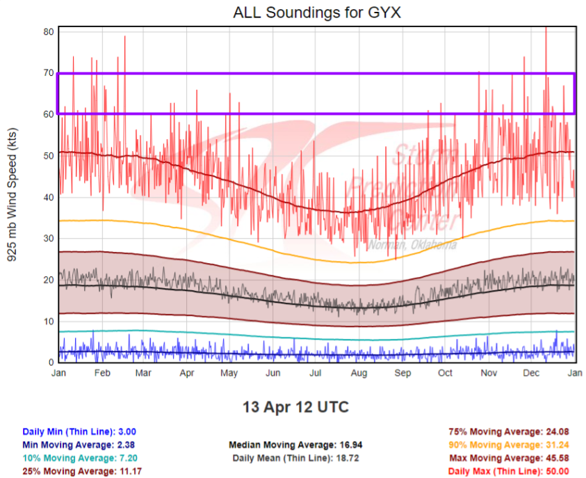
That puts this event in rarified air as far as our climatology goes. Only a handful of @NWSGray soundings have ever exceeded the 60kt threshold!
That puts this event in rarified air as far as our climatology goes. Only a handful of @NWSGray soundings have ever exceeded the 60kt threshold!
Of course the big question is to what extent can these winds mix down to the surface.
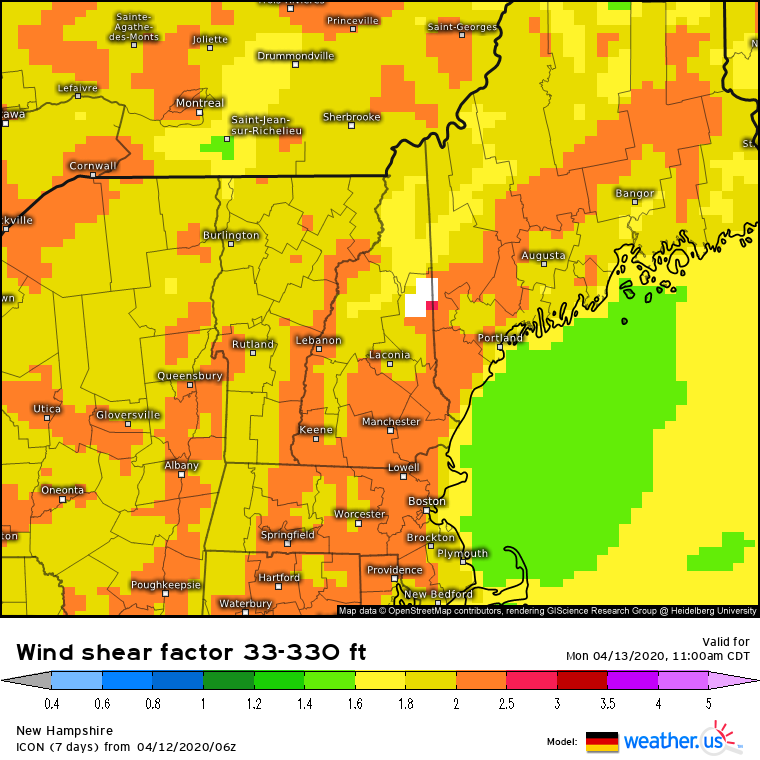
Momentum (wind) wants to mix down the gradient frm high momentum (aloft) to low momentum (at the surface). Remember nature doesn& #39;t like gradients/imbalance!
That gradient will be strong! #MEwx
Momentum (wind) wants to mix down the gradient frm high momentum (aloft) to low momentum (at the surface). Remember nature doesn& #39;t like gradients/imbalance!
That gradient will be strong! #MEwx
Friction acts to inhibit this process by slowing winds at the surface. But near-sfc thermal profiles make a big difference too.
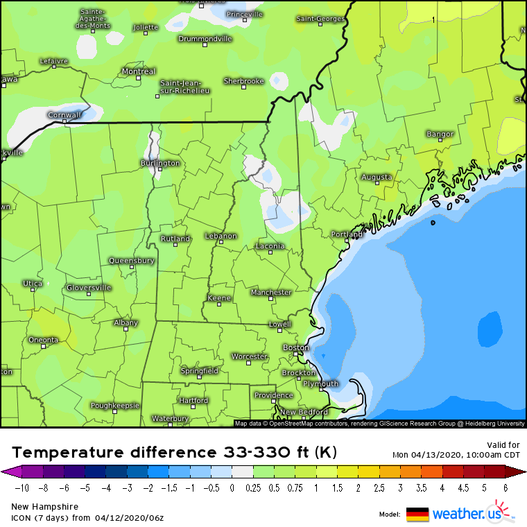
If an inversion is present near the sfc, warm high-momentum air won& #39;t reach the ground (blocked by buoyancy).
We will have an inversion tomorrow #MEwx
If an inversion is present near the sfc, warm high-momentum air won& #39;t reach the ground (blocked by buoyancy).
We will have an inversion tomorrow #MEwx
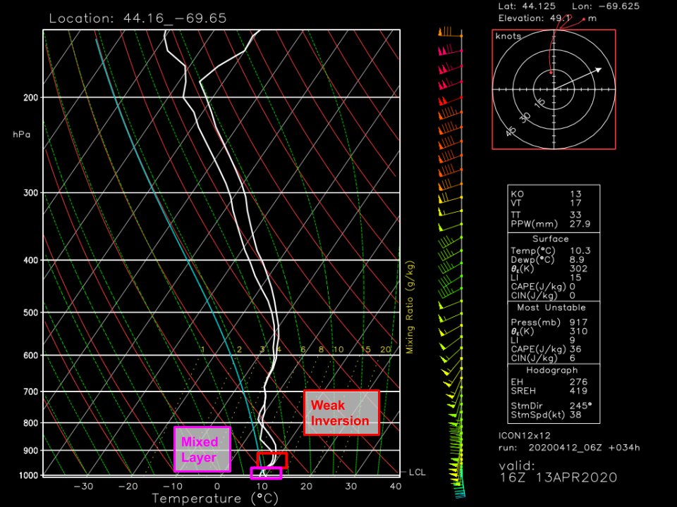
However, this inversion is relatively weak (esp by #MEwx standards) and with such strong winds so close to the surface, it will only be able to keep so much wind aloft.
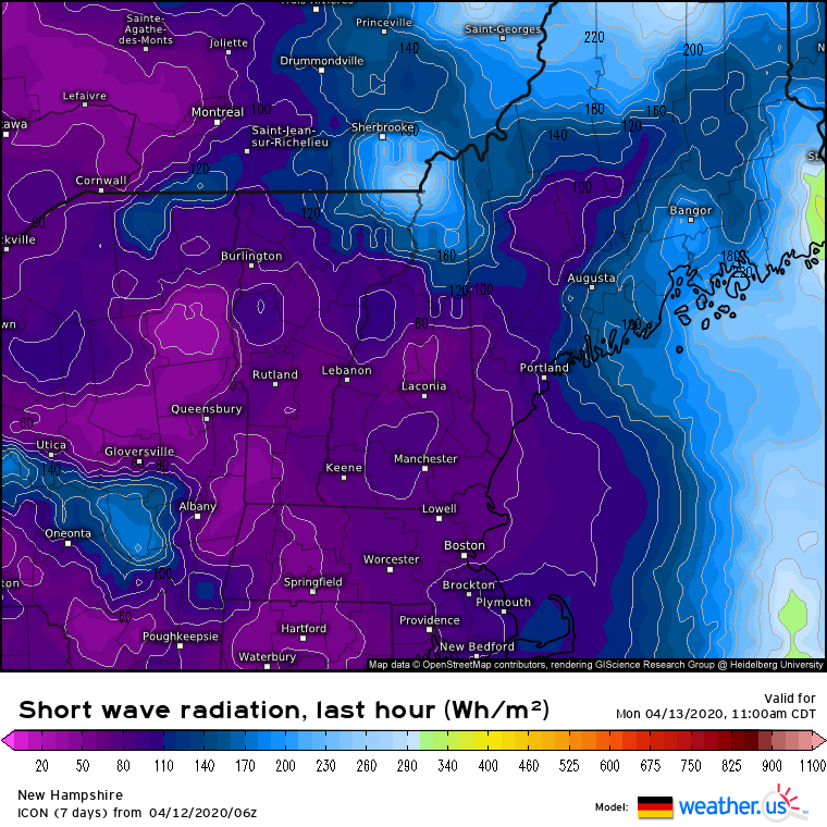
Additionally, the storm is hitting at midday so solar insolation (limited as it may be by clouds) will help weaken the inversion. This is especially the case along the #MEwx "Midcoast" (east of I-95/north of Brunswick) where thicker clouds won& #39;t move in until later in the morning
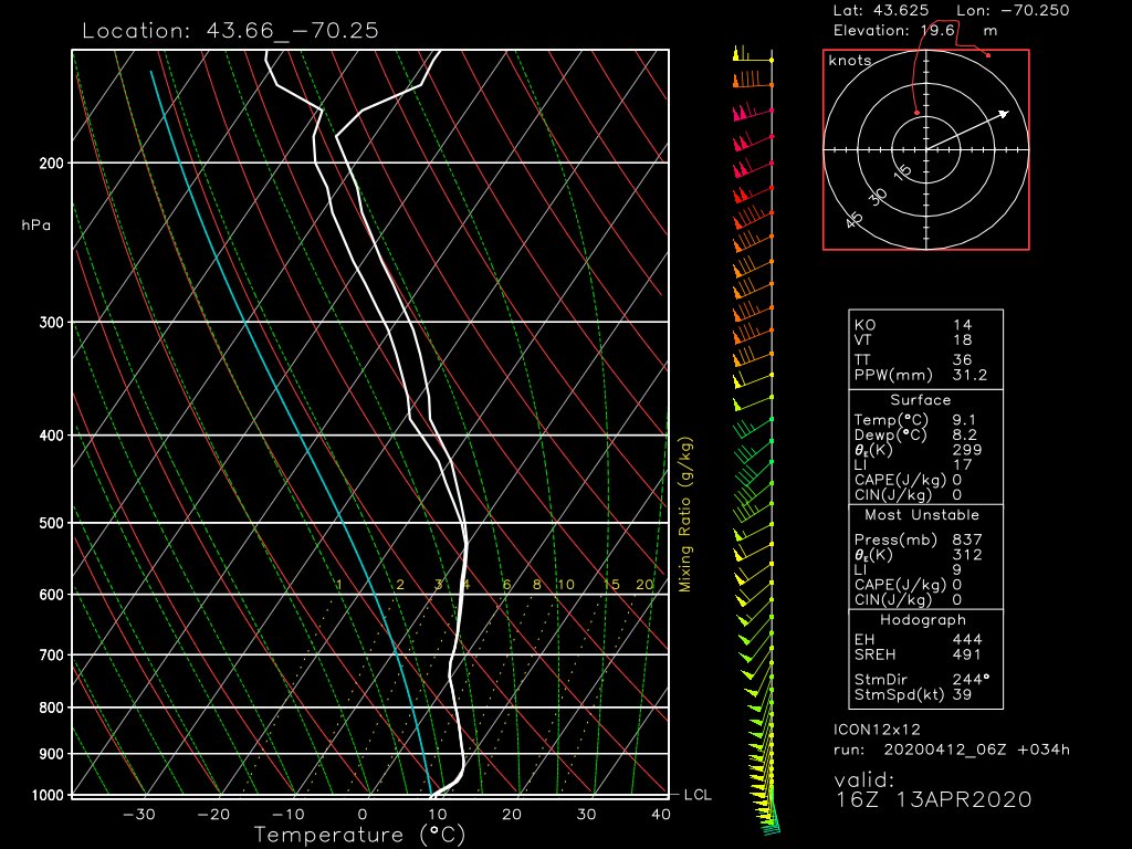
Selecting a forecast sounding in this region, we see a very shallow mixed layer (temps cooling with height) at the surface, below the inversion.
Any winds within this (very shallow) layer can and will make it to the surface as gusts. The deeper the layer, the stronger the winds
Any winds within this (very shallow) layer can and will make it to the surface as gusts. The deeper the layer, the stronger the winds
There& #39;s one more way to get strong winds to the surface, even where an inversion is present: convection.
Convection (even if elevated) can assist in downward momentum transfer by cooling the warm high-momentum air via evaporation, thus reducing the buoyant force keeping it aloft
Convection (even if elevated) can assist in downward momentum transfer by cooling the warm high-momentum air via evaporation, thus reducing the buoyant force keeping it aloft
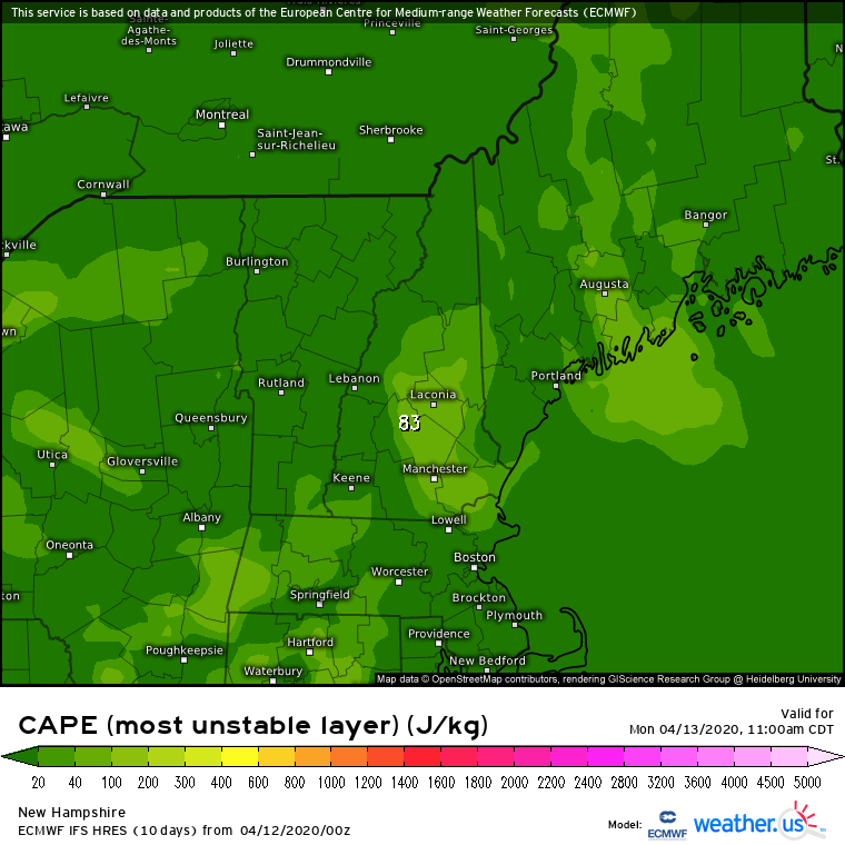
ECMWF (and other) guidance suggests pockets of elevated instability will be present across #MEwx tomorrow as warm/moist air surges north ahead of the approaching cold front.
While this instability isn& #39;t robust enough for severe convection, it won& #39;t take much to mix winds down
While this instability isn& #39;t robust enough for severe convection, it won& #39;t take much to mix winds down
High resolution guidance indicates plenty of convective cells developing especially once mid-level dry air begins moving in from the southwest (enhancing instability).
Any increase in the strength of this convection would be very bad news #MEwx
Any increase in the strength of this convection would be very bad news #MEwx
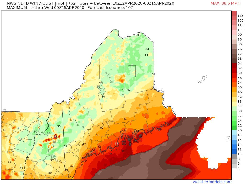
So what& #39;s the bottom line? A substantial high wind event (40-55mph) is likely for the #MEwx coast tomorrow and we& #39;re a couple hours of solar heating, a couple degrees of surface warming, or a couple stronger convective cells away from a memorable damaging wind event (55-65+ mph)
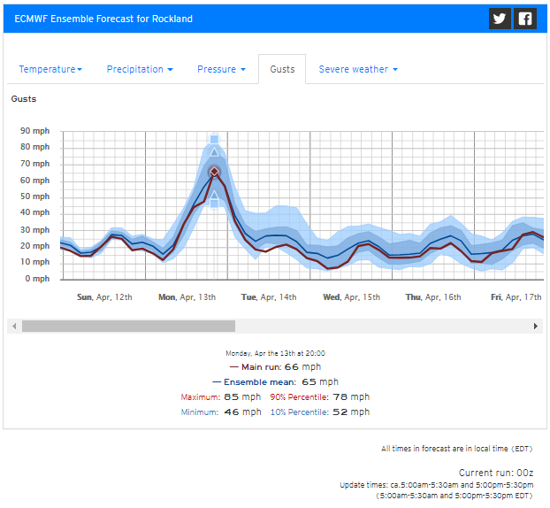
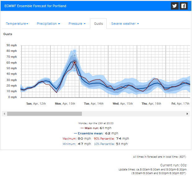
FWIW, EPS guidance seems to represent the range of possible outcomes fairly well (accounting for typical ~10-15% high bias with the gust product).
55mph likely for Rockland, 65-70mph definitely on the table.
Interesting similar numbers for Portland (usually RKD is much windier)
55mph likely for Rockland, 65-70mph definitely on the table.
Interesting similar numbers for Portland (usually RKD is much windier)
That& #39;s the end of the discussion thread. Here are links to the data I used from @WeatherdotUS.
ICON 0-100m shear: https://weather.us/model-charts/german/new-hampshire/wind-shear-factor-10-100/20200413-1600z.html
ICON">https://weather.us/model-cha... 0-100m inversion: https://weather.us/model-charts/german/new-hampshire/temp-diff-10-100/20200413-1600z.html
ICON">https://weather.us/model-cha... solar insolation: https://weather.us/model-charts/german/maine/short-wave-radiation-last-hour/20200413-1600z.html
ECMWF">https://weather.us/model-cha... CAPE: https://weather.us/model-charts/euro/new-hampshire/mu-cape/20200413-1600z.html">https://weather.us/model-cha...
3km NAM radar: https://weather.us/model-charts/conus-hd/new-hampshire/radar-reflectivity/20200413-1500z.html
NWS">https://weather.us/model-cha... max wind gusts: https://lab.weathermodels.com/models/ndfd/nws_max_gusts.php
EPS">https://lab.weathermodels.com/models/nd... city gusts: https://weather.us/forecast/4975802-portland/ensemble/euro/wind-gusts">https://weather.us/forecast/... (PWM) and https://weather.us/forecast/4832458-rockland/ensemble/euro/wind-gusts">https://weather.us/forecast/... (RKD)

 Read on Twitter