
 Read on Twitter
STAY INFORMED: #Easter  https://abs.twimg.com/hashflags... draggable="false" alt=""> Sunday will bring a significant #severewx threat to the #ArLaMsWx. An upper-level disturbance will sweep through the region Sunday AM, bringing the potential for widespread storms. Damaging winds, tornadoes, hail, & pockets of heavy rain are likely. (more)
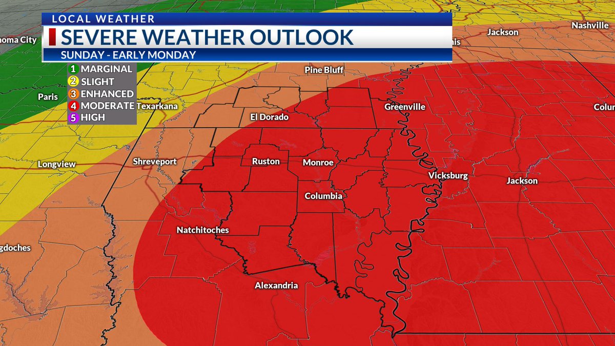 Sunday will bring a significant #severewx threat to the #ArLaMsWx. An upper-level disturbance will sweep through the region Sunday AM, bringing the potential for widespread storms. Damaging winds, tornadoes, hail, & pockets of heavy rain are likely. (more)" title="STAY INFORMED: #Easter https://abs.twimg.com/hashflags... draggable="false" alt=""> Sunday will bring a significant #severewx threat to the #ArLaMsWx. An upper-level disturbance will sweep through the region Sunday AM, bringing the potential for widespread storms. Damaging winds, tornadoes, hail, & pockets of heavy rain are likely. (more)" class="img-responsive" style="max-width:100%;"/>
Again, please keep in mind... despite your categorical outlook designated below, this threat is for the ENTIRE AREA.
We& #39;ve now moved into the Plan/Prepare stages of the forecast. Everyone is encouraged to review their severe weather plan, and be ready to use it on Sunday.


We& #39;ve now moved into the Plan/Prepare stages of the forecast. Everyone is encouraged to review their severe weather plan, and be ready to use it on Sunday.
Easter Services: I highly encourage altering any in-person services that are planned, including & #39;drive-in& #39; services. This would be a great idea on any other Sunday. Online services would be ideal, given the forecast and current social distancing standards.
Time frame: Right now, the timing is becoming slightly clearer. While elevated storms will be possible as early as Saturday night in some locations, the more significant severe threat will wait until around sunrise Sunday morning, and continue through early Sunday afternoon.
Threats: All modes of severe weather will be possible, with an emphasis on damaging wind gusts & tornadoes. Given the highly sheared and unstable environment, a strong tornado or two will be possible. As the forecast continues to become clearer, these threat levels could change.

Altering Your Plan: For those who typically find shelter elsewhere during severe weather, keep in mind the current state of affairs across the country. Social distancing standards may limit your options. Please keep this in mind, and make proper plans to have shelter.
Potential limiting factors: Dry air will move in early Sunday PM from the southwest. If storms are slow to develop, enough dry air (at least, in our area) *could* potentially limit activity. This potential lessens as you move farther east, especially east of the MS River.
Have a plan, stay informed. Our weather center will be fully staffed, as always, to provide you with updates on-air and online as needed through the day on Sunday.
KNOW WHERE YOU ARE: Finally, make sure you know your parish/county on a map. As we provide large amounts of information, this will be critical. Know your surrounding towns, roads, major highways, etc. (end)
")


