FINAL THOUGHTS - The earlier you can get here today/tomorrow morning, the better. Be ready to take it slow and expect delays no matter where you& #39;re coming from. Make sure to give us a follow for the latest info over the next 48 hours. Be safe! - @JackSillin @adm4700
TODAY 11/30/19 there is *no* snow expected. If you are travelling today from anywhere on the East Coast, or can rearrange your plans to travel this afternoon, you will not experience any interruptions as high clouds slowly spill into the northeast.
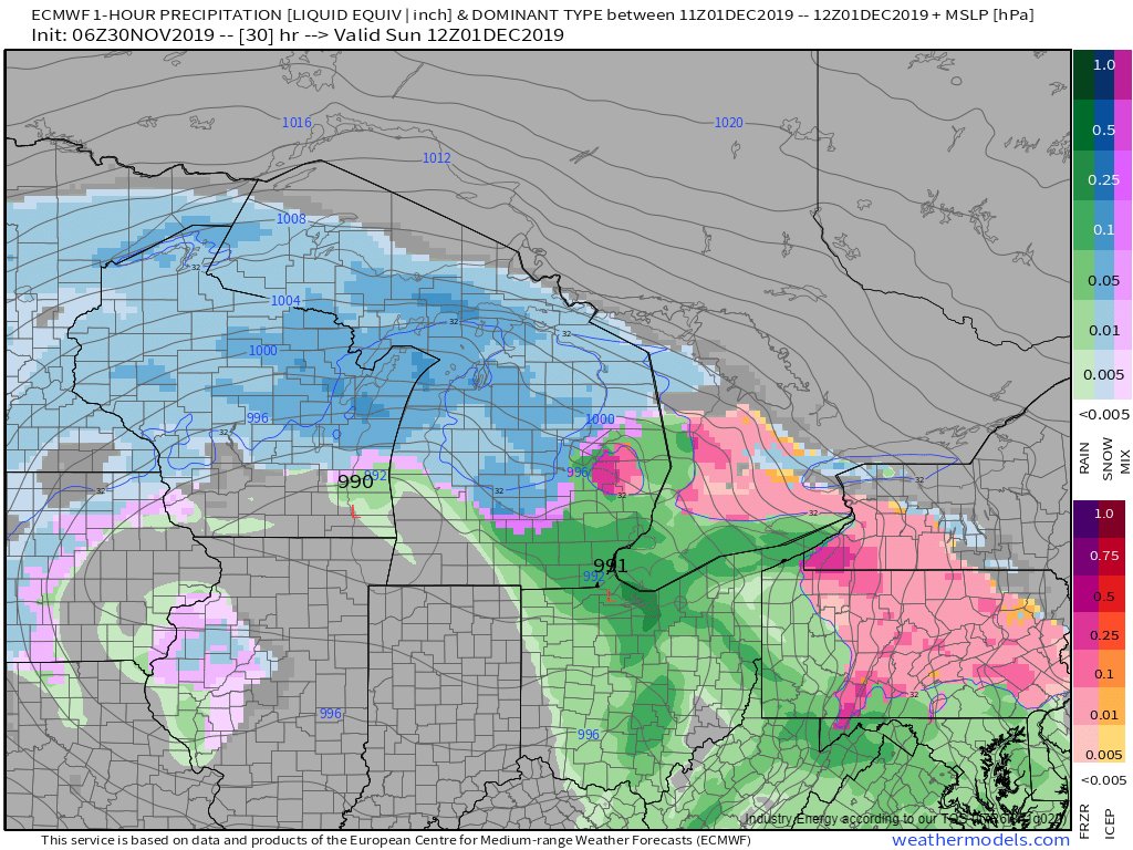
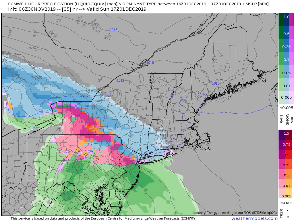
TOMORROW MORNING (6-10 AM 12/1/19) snow will be moving into the area from the southwest. If you have an early flight from Detroit, it may be delayed but SW Michigan is expecting mostly rain, so you should be able to get out. This also applies to early flights from DC
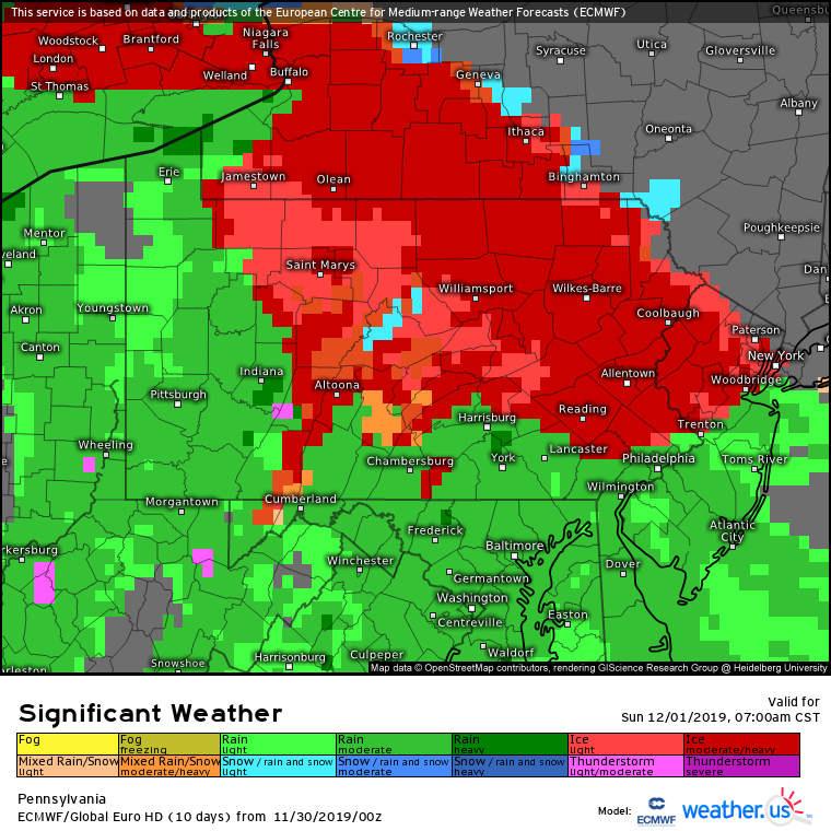
TOMORROW MORNING (6-10 AM) if you& #39;re driving through Pennsylvania, be extremely careful as roads will be covered in ice due to freezing rain. Interstates should be ok as road crews apply salt to keep surfaces wet, but back roads may be very slippery. Allow extra time to get here!
TOMORROW MORNING (6-10 AM) if you& #39;re driving in from the west (Buffalo, Ohio, etc.) expect rain until you get to the PA/NY border, then precipitation will change over to a mix of ice/sleet/snow. Allow plenty of extra time to get here as you& #39;ll need to take it slow
TOMORROW MORNING (6-10 AM) if you& #39;re driving in from the east (NYC, Boston, etc.) expect dry conditions until 8-10 AM when a mix of snow and sleet will begin falling. If you can get to Ithaca by 10 AM, you should avoid substantial delays.
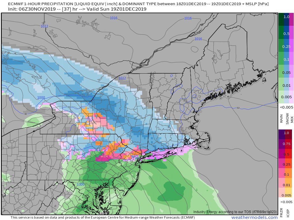
MIDDAY TOMORROW (10 AM-2 PM), we& #39;ll see a burst of heavy snow and sleet here in Ithaca likely between 10 AM and 2 PM. If you& #39;re planning on arriving during this time, expect significant delays as traffic will be moving very slowly across the entire Central NY region
MIDDAY TOMORROW (10 AM-2 PM) if you& #39;re heading through SW NY (Buffalo, Jamestown, etc.) OR north through PA, you& #39;ll be moving quite slowly through heavy freezing rain/sleet. If you& #39;re heading south from ROC/SYR OR east from ALB, you& #39;ll be moving slowly through moderate/heavy snow
MIDDAY TOMORROW (10 AM-2 PM) if you& #39;re flying into ITH/ROC/SYR, delays are likely and cancellations are possible given the onset of moderate/heavy snow and sleet.
TOMORROW AFTERNOON (2 PM-6 PM) snow/mixed precip will be tapering off to the west of Ithaca as drier air moves in aloft. If you& #39;re heading in from Buffalo or Ohio, you won& #39;t encounter much precipitation until you& #39;re into the Finger Lakes, but roads may still be slick
TOMORROW AFTERNOON (2 PM-6PM) heavy snow will be pivoting northeast of Ithaca, making travel very difficult if you& #39;re coming from NYC/CT/ALB/SYR. We strongly advise leaving as early as possible if you& #39;re travelling from these areas!
TOMORROW AFTERNOON (2 PM-6 PM) if you& #39;re flying into ITH/ROC/SYR, expect significant delays and/or cancellations as airport operations become heavily impacted by heavy snow. If you can make arrangements to get on an earlier flight, it would definitely be worth it!
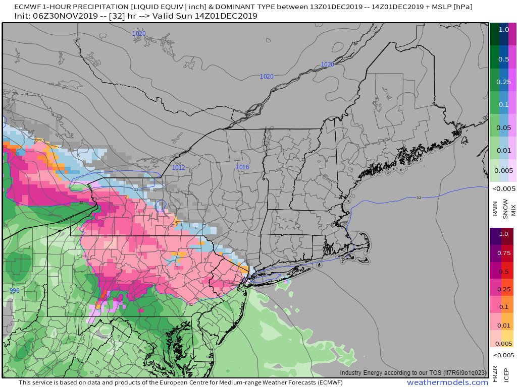
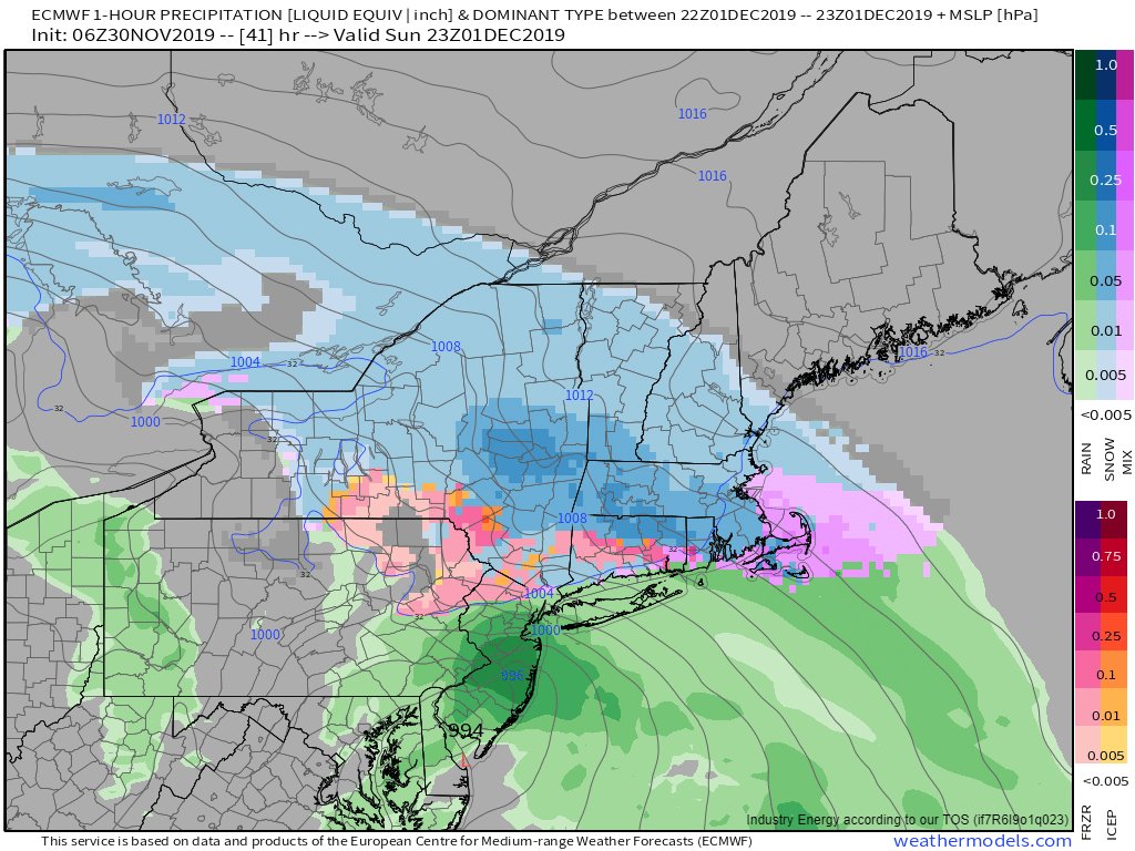
TOMORROW EVENING (6 PM-10 PM) We& #39;ll see a bit of a lull in precipitation during this time as the storm hops over the Appalachian mountains and redevelops in New Jersey. Expect light freezing rain/sleet to switch over to light snow here in Ithaca while heavy snow falls ALB-BOS
TOMORROW EVENING (6 PM-10 PM) If you& #39;re driving in from the west or south (Buffalo/OH/PA/NYC/etc.) you& #39;ll encounter only light precipitation, much of which will be rain or freezing rain until you get close to Ithaca. Roads may still be slick, but overall you should be OK.
TOMORROW EVENING (6 PM-10 PM) If you& #39;re driving in from the north (ROC/SYR) you& #39;ll encounter light to moderate snow which will make roads slick but not impassible. If you& #39;re willing to go slow, you should be fine driving during this time
TOMORROW EVENING (6 PM-10 PM) If you& #39;re driving in from the east (ALB/BOS), you& #39;ll encounter very heavy snow and treacherous road conditions on I-90 and I-88. If it& #39;s at all possible, don& #39;t drive through here during this time! Snowfall rates will be >2" per hour
TOMORROW EVENING (6 PM-10 PM) If you have a flight into ITH/ROC/SYR during this time, you& #39;ll likely encounter some delays, but planes should be able to land after they clear off the snow from earlier in the afternoon.
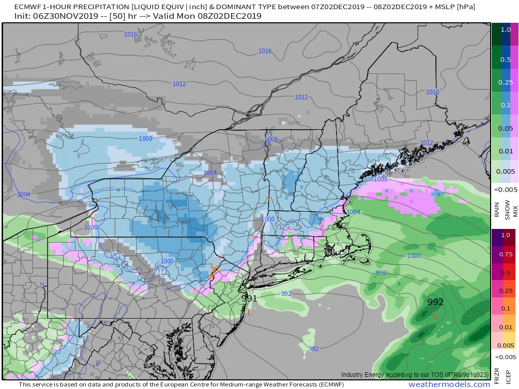
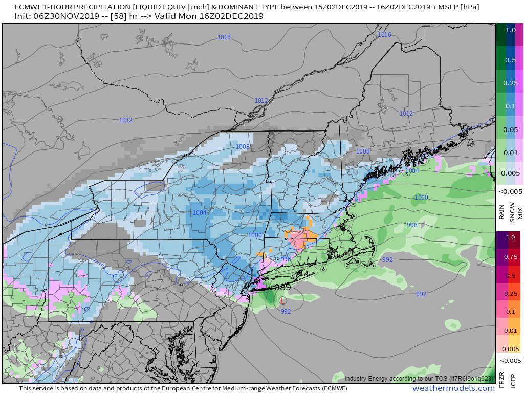
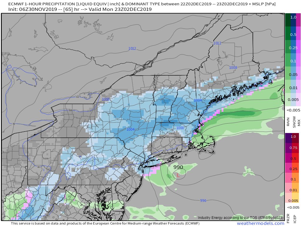
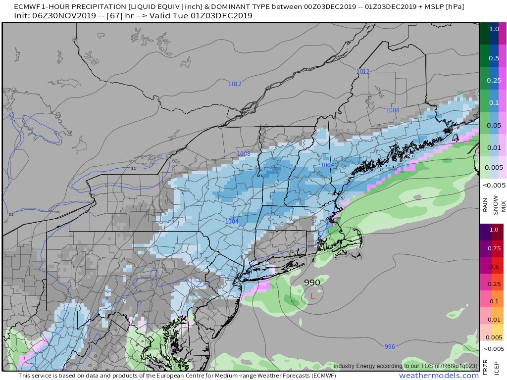
TOMORROW NIGHT (10 PM-4 AM) Bands of heavy snow will develop again over the Ithaca area as the storm strengthens near NYC. If you& #39;re not here by midnight, it& #39;s probably best to wait until later in the day on Monday. Snow could fall at rates of 1-2" per hour
MONDAY MORNING (4 AM-10 AM) bands of moderate to heavy snow will remain over the Ithaca area as the storm remains more or less stationary near Long Island. Travel from the east or southeast (ALB/BOS/NYC/CT) will be extremely difficult while conditions will improve to the west
MONDAY MORNING (4 AM-10 AM) if you& #39;re flying into ITH/ROC/SYR, expect significant delays and/or cancellations as heavy snow will be a challenge for airport crews to keep up with. If you can get on a flight tomorrow AM, that would be ideal but otherwise, your best bet is Tuesday
MONDAY MIDDAY/AFTERNOON (10 AM-6 PM) moderate snow will continue through the day on Monday from Ithaca east into New England. Travel from the west will improve, but roads east of Ithaca will remain treacherous as heavy snow continues to fall in eastern NY/New England
MONDAY EVENING (6 PM-10 PM) snow will taper off as NW winds bring drier air into the region and the storm moves into the Gulf of Maine. Roads will remain hazardous to the east of Ithaca, but you should be ok if you& #39;re heading in from Buffalo or points SW.
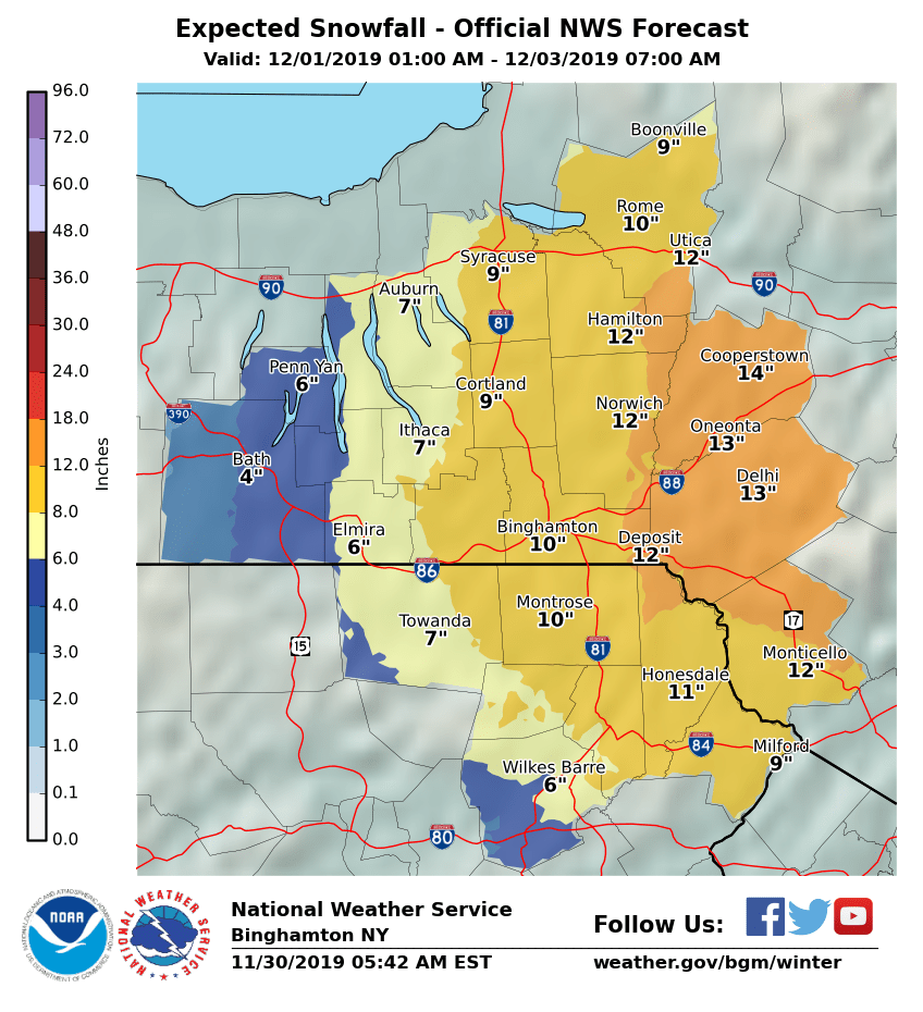
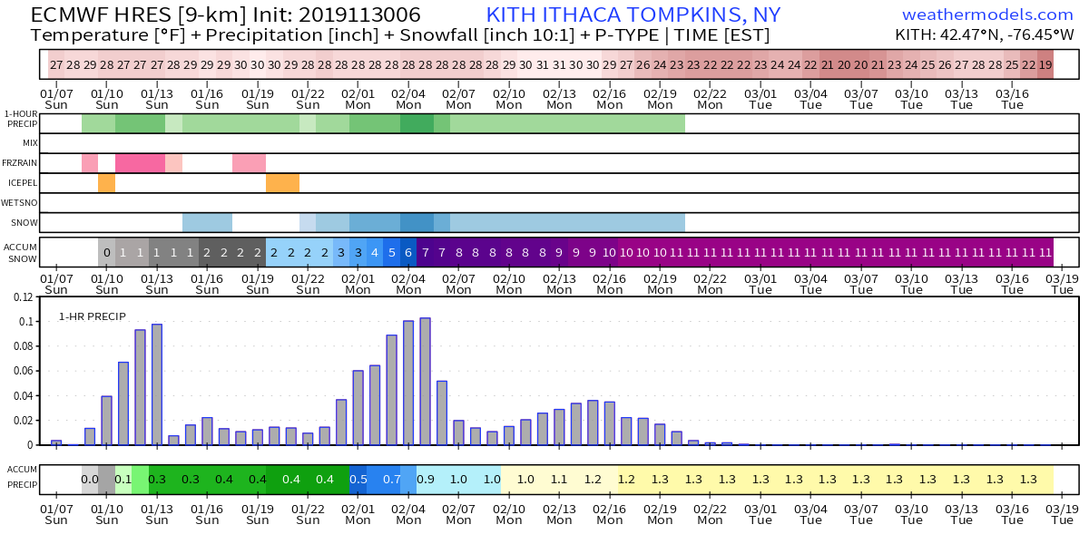
OVERVIEW - Snow will develop tomorrow morning around 9-10 AM in Ithaca (earlier SW, later NE) becoming moderate/heavy at times before mixing with sleet/freezing rain midday tomorrow. A lull is expected mid/late tomorrow afternoon before heavy snow returns tomorrow night
OVERVIEW - Moderate/heavy snow will continue through the day on Monday before tapering off Monday evening. This graph gives a good general idea of what to expect hour-by-hour in Ithaca in terms of precipitation intensity (top precip bar), and type (the next four bars).
FINAL THOUGHTS - The earlier you can get here today/tomorrow morning, the better. Be ready to take it slow and expect delays no matter where you& #39;re coming from. Make sure to give us a follow for the latest info over the next 48 hours. Be safe! - @JackSillin @adm4700

 Read on Twitter