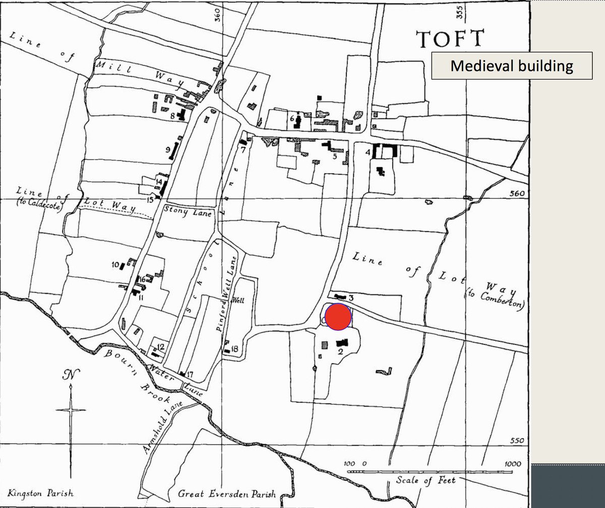
THREAD. Well, here’s a thing. This is Toft in Cambs. - &, as you can see, the church (red dot) is quite a way from the village which lies to the NW, W & SW. Only the rectory & its cottages stand nr the church. Why the distance between church & village? ( https://www.british-history.ac.uk/rchme/cambs/vol1/pp207-210)">https://www.british-history.ac.uk/rchme/cam...
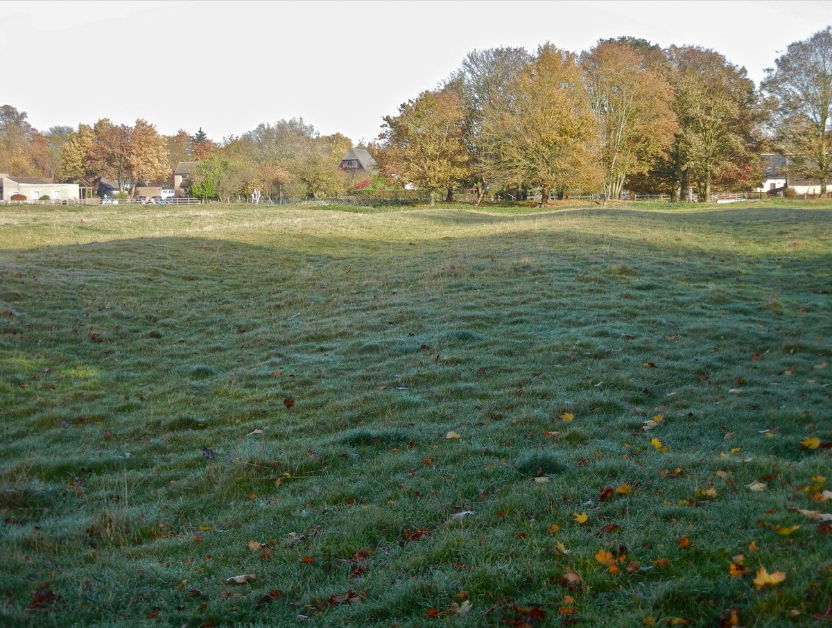
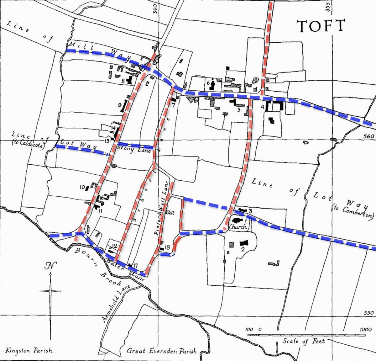
2. A large field with the earthworks of medieval ploughing lies between the church & the village. The RCHM thought that the village had once been planned on a grid, but that over time ...
3. ... the central part of the grid had been abandoned leaving the houses around the edge & separate from the church. & it’s true that the village streets do look a bit gridlike but the W/E lines (blue) don’t really join up - so maybe a decayed grid isn’t such a good explanation?
4. It came to me one day, driving around a roundabout (why?) that the history of the field might help to answer the Q. Could it be possible that the field overlay the abandoned village? How old were the ridges in it?
5. The church is bottom L of centre in the photo which looks mostly W. The field is in the middle of the photo. The slight backward-S curve of the ridges shows that the ridge & furrow is medieval, created by an ox-drawn plough.
6. The lane (on the far side of the field from the church) preserves that lovely backward-S curve. It seems that 1 or 2 ridges were hedged to make the lane.
So, could the field have been ploughed over abandoned properties? And, if so, when was that most likely to have happened?
So, could the field have been ploughed over abandoned properties? And, if so, when was that most likely to have happened?
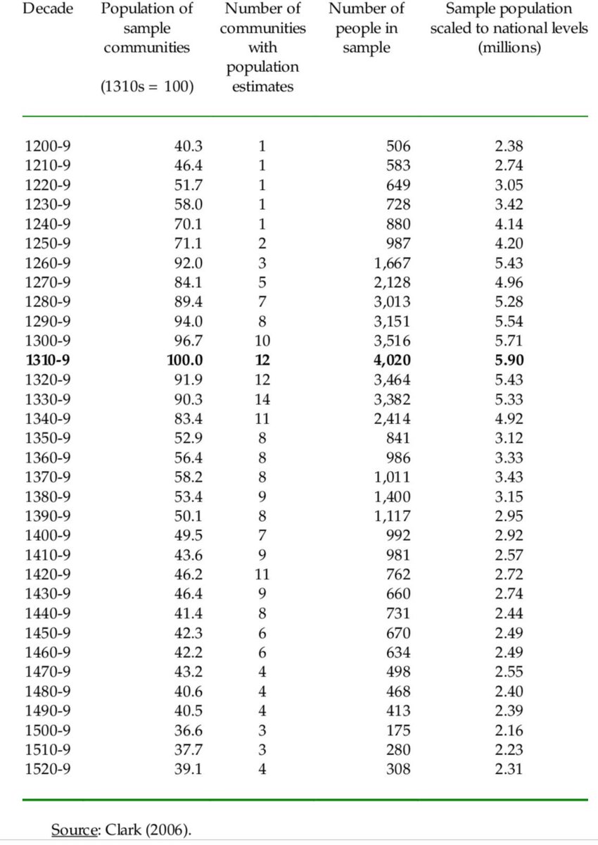
7. The population of England may have doubled in the 13thC, & then fell away after the Black Death of 1348-50. So, if the field replaced the village it would have to have been after 1350-ish. Can we tell when the field was last ploughed? (Source: https://www.researchgate.net/figure/Estimating-Medieval-English-Population_tbl1_228455000)">https://www.researchgate.net/figure/Es...
8. Yes, we can! See those low mounds at the end of each ridge? They’re called ‘heads’. As the plough is taken out of the soil at the end of each plough-run it drops a small amount of earth which gradually builds up to make the head.
9. As you can see, the heads are right next to the hedge (on the LH side of the field in the centre of the photo.) There isn’t enough room between the heads & the hedge to turn a ploughteam of 8 oxen (spanned in pairs) & a plough. So ...
10. .. the field can’t have been ploughed after the hedge was planted. Can we tell how old the hedge is? Well, maybe. Hedgerow dating is a bit controversial these days. But on the other hand (a) it was developed in Cambs by comparing hedges of known date..
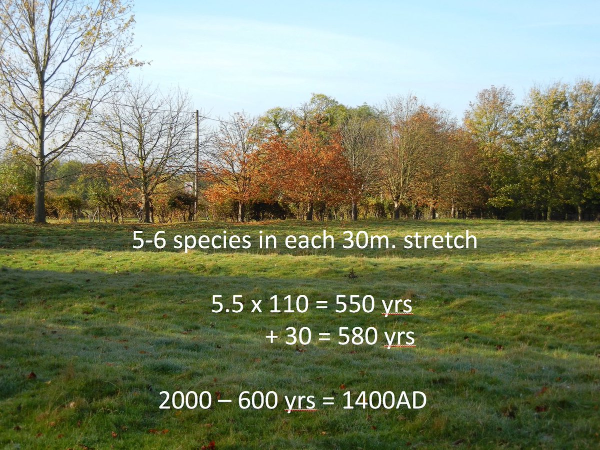
11. And (b) the late great Oliver Rackham believed it worked. So, on that basis, let’s proceed. The theory is that many *planted* medieval hedges were single species, generally hawthorn. & roughly 1 new species was added to the hedge each century. One counts the woody species ..
12. .. - the ones that don’t die back in winter - in as many 30m stretches as possible. Then multiply the average no. of species across the 30m lengths by 110, and then add 30 (don’t ask me why add 30 - this was Rackham’s formula). So counting the species in our hedge in Toft..
13. .. gives this result: a hedge planted around 1400. So the field cannot have been ploughed after the late 14thC. The ridge & furrow must have been created while the population was still growing. So it’s very unlikely that the field lies over an abandoned part of the village.
14. So why is the church at Toft at a distance from the village? Alas, I don’t know. It’s just v unlikely that it’s the result of population decline - it seems always to have been isolated, at least in the medieval period.
15. Which all goes to show that, even if one doesn’t get the answer one was looking for, there’s a vast amount of fun in exploring the history of the landscape - and it’s available to us all  https://abs.twimg.com/emoji/v2/... draggable="false" alt="😝" title="Squinting face with tongue" aria-label="Emoji: Squinting face with tongue"> END

 Read on Twitter





 END" title="15. Which all goes to show that, even if one doesn’t get the answer one was looking for, there’s a vast amount of fun in exploring the history of the landscape - and it’s available to us all https://abs.twimg.com/emoji/v2/... draggable="false" alt="😝" title="Squinting face with tongue" aria-label="Emoji: Squinting face with tongue"> END" class="img-responsive" style="max-width:100%;"/>


